Prosper in a dynamic world
Search

MJO imminent for Australian region


Parts of northern Australia could see a wet end to March as the Madden-Julian Oscillation (MJO) moves through the Australian region. The MJO is a pulse of increased cloudiness and rainfall that travels around the world near the equator every 30-60 days.

The MJO has been weak and indiscernible in recent weeks, meaning it has little influence on the weather. However, it is forecast to strengthen and move into the Australian region over the coming week and possibly linger until mid-April. When the MJO is near Australia, it increases the likelihood of rain, thunderstorms and tropical cyclones in our region.

At this stage, it’s too early to know exactly how this pulse of the MJO will affect Australia, including where and when any tropical cyclones will develop. However, the map below shows the increasing likelihood of rainfall over a large area of northern and eastern Australia during the next fortnight.

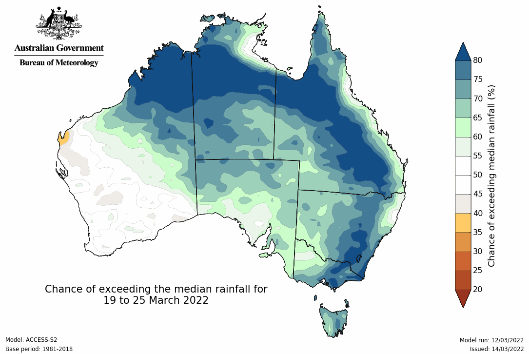
Image: Probability of exceeding the median rainfall during the fortnight ending on March 25, 2022. Source: Bureau of Meteorology.

The strong signal of above-average rainfall in the map above is partially being caused by the impending MJO. It is also being influenced by the ongoing La Niña in the Pacific Ocean, which has regained strength in the last fortnight and is likely to persist until at least late-autumn.

The map above shows the rainfall outlook from the Bureau of Meteorology’s ACCESS-S seasonal forecast model, which is a good guide for general rainfall trends. However, more discreet details about where and when rain will fall will become available over the coming weeks as we move into the range of higher-resolution numerical weather prediction models. For more information, please contact us at apac.sales@dtn.com.

Latest news

Satisfy your weather obsession with these news headlines from around the nation, and the world.

El Niño Is Here: What a Potential Record Event Means for Southeast Asia and Australia

  El Niño was officially declared in June 2026, raising the prospect of widespread impacts across Southeast Asia, from extreme heat and water shortages to higher energy demand and agricultural stress.   The World Meteorological Organization has warned countries to “prepare for it to be severe”, while several global forecast models suggest the event could rank among […]

How El Niño will shape Australian port operations in winter-spring 2026

Australian ports and marine pilots can expect a season of shifting wind and swell patterns through winter and spring 2026, as a developing El Niño brings the likelihood of drier conditions and more variable operating windows across the country’s coastline.  Will El Niño develop in 2026?  There are clear signs that an El Niño pattern is becoming […]

From Kimberley to northern NSW: Bushfire outlook flags risk for resources sector this winter

Bushfire risk doesn’t usually make headlines in June, but AFAC’s winter seasonal outlook is putting mining and resources operators on alert from the Kimberley to the NSW.  Australia’s official seasonal bushfire outlook for winter 2026 was released by AFAC on Thursday, May 28. The outlook predicts increased fire risk across the northern parts of the Great Sandy Desert and surrounds […]

The signal was there weeks earlier: forecasting one of the year’s biggest wind events

In mid-May 2026, DTN APAC meteorologists flagged a strengthening Southern Ocean pattern in model guidance, signalling an extended run of record-challenging wind conditions across the NEM.  Nearly three weeks later, NEM wind generation climbed from around 1.5GW to more than 9GW, supplying roughly one-third of the grid and coming within 1GW of the all-time generation record.  The event highlighted […]