
A prolonged period of wintry weather is set to impact parts of WA during the next five days, bringing relentless rain, thunderstorms, wind and cloud cover to some areas.
This prolonged spell of wet and stormy weather will be produced by a near stationary low-pressure system which is expected to linger off the southwest coast for several days.
The satellite image below shows a thick cloud band streaming across western WA on Thursday morning.

Image: Visible satellite image at 1pm on Thursday, June 9.
The thick cloud band and associated moisture streaming in from the Indian Ocean is producing rain and storms across parts of WA on Thursday morning.
This rain will continue across parts of western and southern WA for several days until the low eventually east away from the state from Monday.
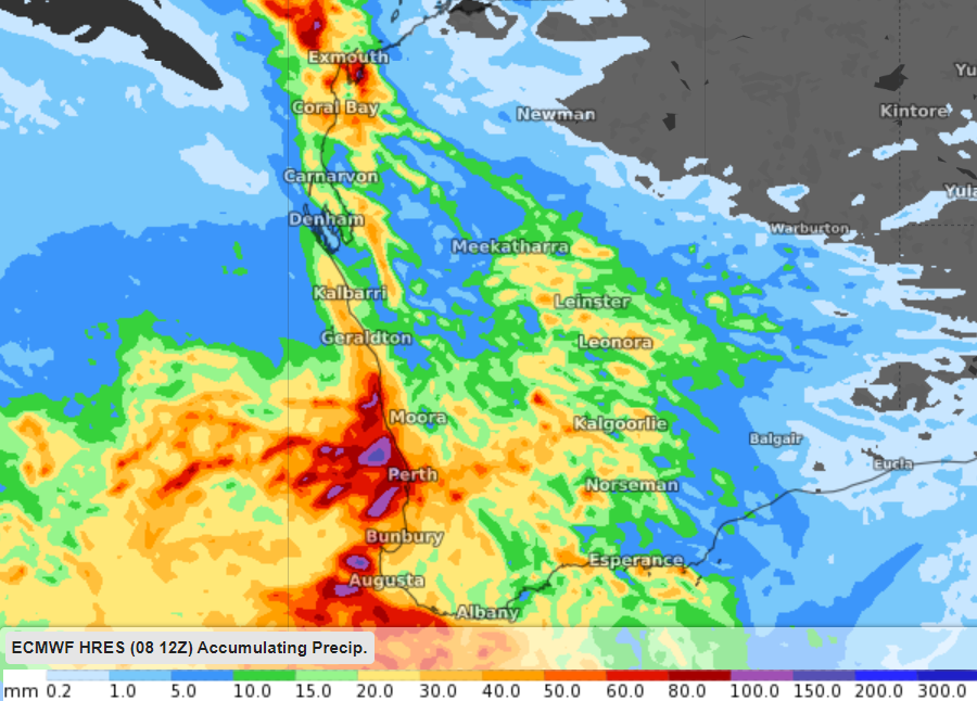
The map below shows one model’s accumulated rain forecast in WA over the next four days, with widespread totals of 30 to 50mm forecast across parts of western and southern WA.

Image: ECMWF accumulated rainfall forecast between Thursday and Monday, June 13.
Exposed coastal areas in the Pilbara and Gascoyne districts and parts of the southwestern districts should accumulate the largest totals, with some areas forecast to pick up 80 to 100 mm.
In addition to the rain, thunderstorms could produce heavy rainfall in the coming days, which may prompt severe thunderstorm warnings to be issued.
These thunderstorms are mostly likely to impact parts of the Pilbara and Gascoyne districts on Friday and early Saturday as the low nears the coast and extends a trough over the region.
The low will also whip up strong winds across western and southern WA, which should elevate wind power for several days. The strongest winds are forecast on the weekend or early next week in the far southwest corner of WA as the low clips the area. A damaging wind warning may be issued as a surge of powerful winds sweep across the region.
The map below shows the instantaneous wind gust forecast on Monday morning, with the strongest winds clipping far southwestern WA.

Image: ECMWF instantaneous wind gust forecast on Monday morning.
This wintry weather should ease on Monday or Tuesday as the low pressure system moves east away from the state. For more information on Weatherzone’s thunderstorm, wind, rain and cloud forecasting, please contact us at apac.sales@dtn.com.




