
A blast of cold air will move over southern Australia this week causing a wintry mix of snow, hail, rain and blustery winds.
A large mass of cold air originating from water near Antarctica is moving towards Australia from the south. The satellite image below shows this polar air mass over the Southern Ocean on Monday, highlighted by the blue oval.

A strong cold front will move through SA on Tuesday, before sweeping through VIC, TAS, NSW and the ACT on Wednesday and Thursday.
This powerful front will cause temperatures to drop around 5 to 10 degrees across a broad area of southern Australia. Days and nights will both become noticeably cold behind the front and many areas likely to see their lowest temperatures so far this year.
Most of Australia’s population will feel the chill from this system:
- Melbourne and Hobart should only reach about 13 to 14 degrees on Thursday and Friday, with overnight temperatures dropping to about 8 to 9 degrees.
- Daytime temperatures in Adelaide will top 15 to 17 degrees on Wednesday, Thursday and Friday, with nights cooling to about 9 degrees.
- Canberra will struggle to reach the mid-teens from Thursday and could only climb to 11 to 12 degrees on Friday and Saturday. Overnight temperatures in the nation’s capital should drop close to zero on Friday and Saturday mornings.
- Sydney should only reach about 19 to 21 degrees from Thursday to Saturday and minimums could hit single figures on Friday and Saturday mornings.
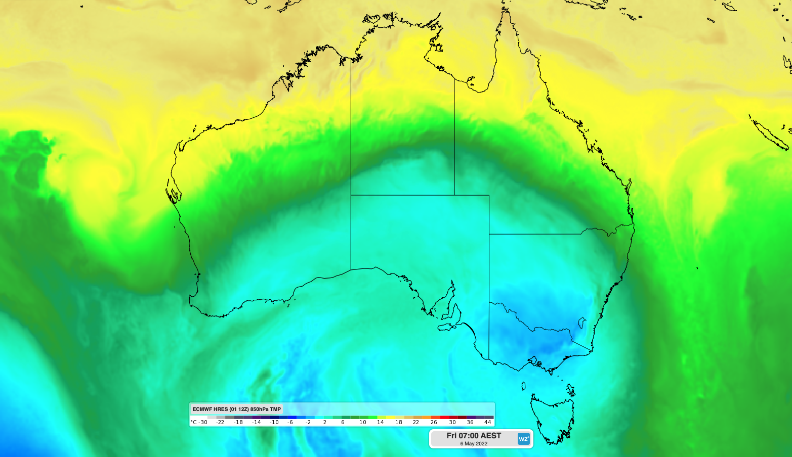
This cold air mass could also cause the first frost of the year in central Australia and deliver the first decent snow of the season in mountainous areas of southeastern Australia later this week.

Image: Forecast air temperature around 1.5 km above the ground, showing cold air spreading over southern and central Australia on Friday morning.
Snow could reach about 900 metres above sea level from Thursday and possibly get even lower in parts of TAS, VIC and southern NSW on Friday. This should deliver the first decent snowfall of the season in the alpine areas, giving ski resorts a taste of what’s to come this winter.
In addition to snow, the impending cold air mass will also produce small hail and rain in some areas.
There are early signs that a small low pressure system could deliver a burst of heavy rain in southern and eastern TAS between Thursday and Saturday, with potential for more than 50 mm in 24 hours.

Image: Forecast accumulated rain between Monday and Saturday, according to the ECMWF-HRES model.
This wintry mix of hail, snow and rain will also be exacerbated by blustery winds near and behind the front, with wind chill likely to make it feel several degrees colder than it actually is for some places.
Cool air will linger across southeastern Australia into the weekend before milder air returns early next week. For more information on Weatherzone’s temperature and extreme temperature forecasts, please contact us at apac.sales@dtn.com.




