Prosper in a dynamic world
Search

How many rainy days has Sydney had this year?


Sydney is having one of its rainiest years on record based on the number of rain days in the city since the start of 2022.

In an average year, Sydney would register rain on 88 days between January and July and around 162 days over the entire.

So far in 2022, the city has already seen 123 days of rain, making this Sydney’s 4th rainiest year-to-date in records dating back to 1859, based on the number of rain days. Only three other years have had more than 123 rain days in Sydney between January 1 and July 25:

  1. 1890 with 136 days
  2. 1893 with 130 days
  3. 1989 with 125 days

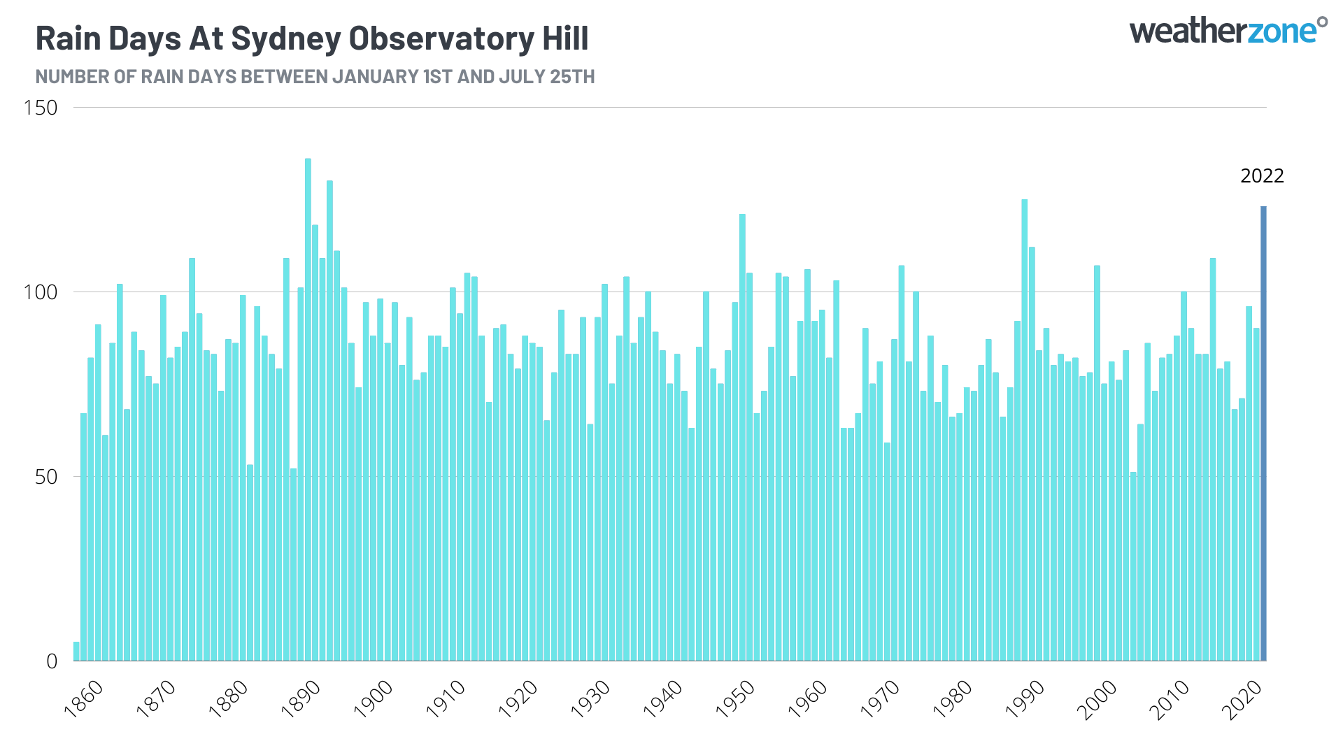
A combination of La Niña, a predominantly positive Southern Annular Mode, abnormally warm water in the Tasman Sea and relentless rain-inducing weather systems have been responsible for the prolific rain in Sydney this year.

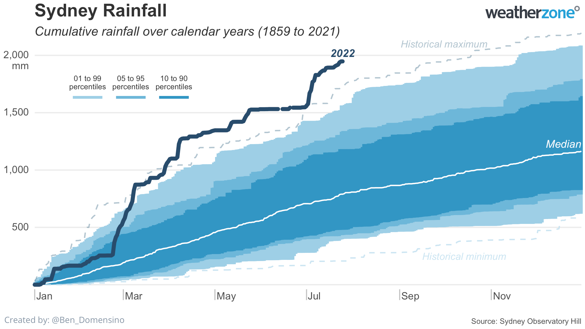
But while this has been Sydney’s 4th rainiest year-to-date on record based on rain days, it is by far the wettest on record based on accumulated rainfall.

As of 9am on Monday, July 25, Sydney had received 1947.4mm of rain since the beginning of 2022. This is more than 200mm above the previous wettest year-to-date on record, which was 1728.6 mm to the same date in 1950.

For more information on Weatherzone’s seasonal rainfall forecasts and heavy rainfall alerts, please contact us at apac.sales@dtn.com.

Latest news

Satisfy your weather obsession with these news headlines from around the nation, and the world.

El Niño Is Here: What a Potential Record Event Means for Southeast Asia and Australia

  El Niño was officially declared in June 2026, raising the prospect of widespread impacts across Southeast Asia, from extreme heat and water shortages to higher energy demand and agricultural stress.   The World Meteorological Organization has warned countries to “prepare for it to be severe”, while several global forecast models suggest the event could rank among […]

How El Niño will shape Australian port operations in winter-spring 2026

Australian ports and marine pilots can expect a season of shifting wind and swell patterns through winter and spring 2026, as a developing El Niño brings the likelihood of drier conditions and more variable operating windows across the country’s coastline.  Will El Niño develop in 2026?  There are clear signs that an El Niño pattern is becoming […]

From Kimberley to northern NSW: Bushfire outlook flags risk for resources sector this winter

Bushfire risk doesn’t usually make headlines in June, but AFAC’s winter seasonal outlook is putting mining and resources operators on alert from the Kimberley to the NSW.  Australia’s official seasonal bushfire outlook for winter 2026 was released by AFAC on Thursday, May 28. The outlook predicts increased fire risk across the northern parts of the Great Sandy Desert and surrounds […]

The signal was there weeks earlier: forecasting one of the year’s biggest wind events

In mid-May 2026, DTN APAC meteorologists flagged a strengthening Southern Ocean pattern in model guidance, signalling an extended run of record-challenging wind conditions across the NEM.  Nearly three weeks later, NEM wind generation climbed from around 1.5GW to more than 9GW, supplying roughly one-third of the grid and coming within 1GW of the all-time generation record.  The event highlighted […]