
Prosper in a dynamic world
Search

Heavy rain moving north in NSW


The rain-bearing low pressure trough that drenched central eastern NSW over the last four days will move further north during the next 24 to 48 hours with more flooding possible. 

A near-stationary trough of low pressure near central NSW coast produced a lengthy spell of heavy rain in the Illawarra, Sydney and Hunter regions over the past four days. 

Now, this trough is moving further north, with heavy rain and areas of flooding likely to spread over the state’s Hunter and Mid North Coast districts during the next 24 to 48 hours. 

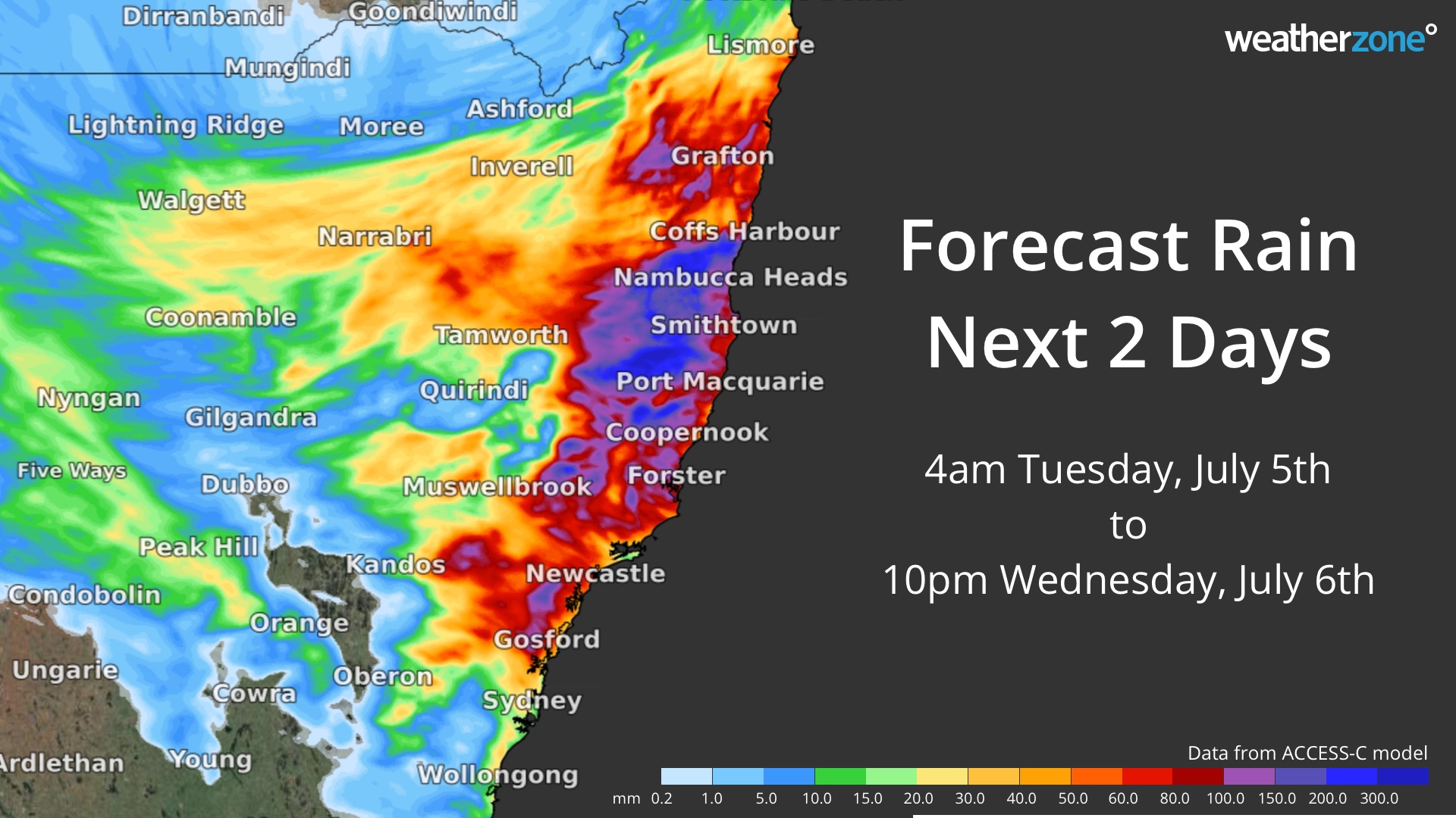
The map below shows how much rain one computer model is predicting during Tuesday and Wednesday combined, with the potential for more than 100 mm of rain in some areas over the next two days. 

MicrosoftTeams-image (487)

 Image: Forecast accumulated rain between 4am on Tuesday and 10pm on Wednesday (AEST), according to the ACCESS-C model. 

As rain spreads further north over the next two days, there is potential that it may be enhanced by a Tasman Low drifting close to the NSW coast. If this happens, rainfall totals may exceed 200 mm in some areas. 

At 2pm AEST on Tuesday, a severe weather warning was in place of heavy rain and flash flooding in parts of the Hunter and lower Mid North Coast. A flood warning is also in place for moderate to major flooding in the Wollombi Brook and Lower Hunter River, while a flood watch is in effect for parts of the Mid North Coast from Wednesday. 

At this stage, rain should ease on Thursday as the low moves away from the coast. However, this is a dynamic system and forecasts may change over the coming days. Be sure to check the latest warnings and forecasts for the most up-to-date information. For more information on our heavy rainfall, rainfall and our seasonal forecast, please contact us at apac.sales@dtn.com.


Latest news

Satisfy your weather obsession with these news headlines from around the nation, and the world.

Signs of a positive Indian Ocean Dipole, but it may not follow the textbook

Waters off Indonesia have cooled in recent weeks, an indication that a positive Indian Ocean Dipole (IOD) event could be developing. It’s an important climate driver for Australia, and it could shape rainfall and temperatures heading into summer, with flow-on effects for farmers, energy and other industries.  What is the Indian Ocean Dipole?  The IOD […]

1.3 million lightning strikes and a record September downpour: the storms testing WA’s Goldfields

Leonora, WA, had its wettest September day on record earlier this month. Three weeks later, more than 1.3 million lightning pulses were detected within 800 km of the town in 48 hours. Why is a stalled trough delivering storms to mining country, and what it could mean for operations?  The DTN Total Lightning Network detected […]

A very low wind power week, likely to continue

A stubborn blocking high over southern Australia will make for a very quiet week for wind generation and the pattern behind it isn’t a one-off.   It’s the seasonal signature of a super (very strong) El Niño combined with a positive Southern Annular Mode (SAM), and both the historical record and the current seasonal forecast suggest it’s likely to keep recurring through spring before a potential switch from November.  The setup right […]

Fastest strengthening El Niño on record: Impacts on Australian monsoon timing and wet season planning

Australia’s Mining and Resources sectors are bracing for a wet season shaped by one of the most rapidly developing El Niño events on record.    Looking back at how the strongest El Niño events in Australian history have played out, it becomes apparent that mining operations in Australia should be planning for a later monsoon […]

