Prosper in a dynamic world
Search

Heaviest August rain in over a century hits outback QLD


A rare late-winter soaking has swept across outback QLD during the last 24 hours, with some places picking up their heaviest August rain in more than 100 years.

The animation below shows rain, thunderstorms and thick cloud spreading over QLD on Monday into Tuesday morning. This rain-bearing cloudband was caused by tropical moisture feeding into a broad low pressure trough.

Video: Composite satellite, radar and lightning strikes on Monday and Tuesday morning.

Widespread falls of 30 to 70 mm were recorded across outback QLD during the 24 hours to 9am on Tuesday, including 68.9mm at Winton, 64 mm at Muttaburra, 51.4 mm at Camooweal and 35.6 mm at Longreach.

This much rain is rare to see at this time of year.

For Longreach (35.6 mm), Muttaburra (64 mm) and Winton (68.9 mm), this was the wettest August day since 1947 and well in excess of their August monthly averages of 10.7 mm, 9.5 mm and 6.5 mm and respectively.

Further west, Camooweal’s 51.4mm was the site’s wettest August day since 1893 and close to 18 times its long-term August monthly average of 2.9 mm.

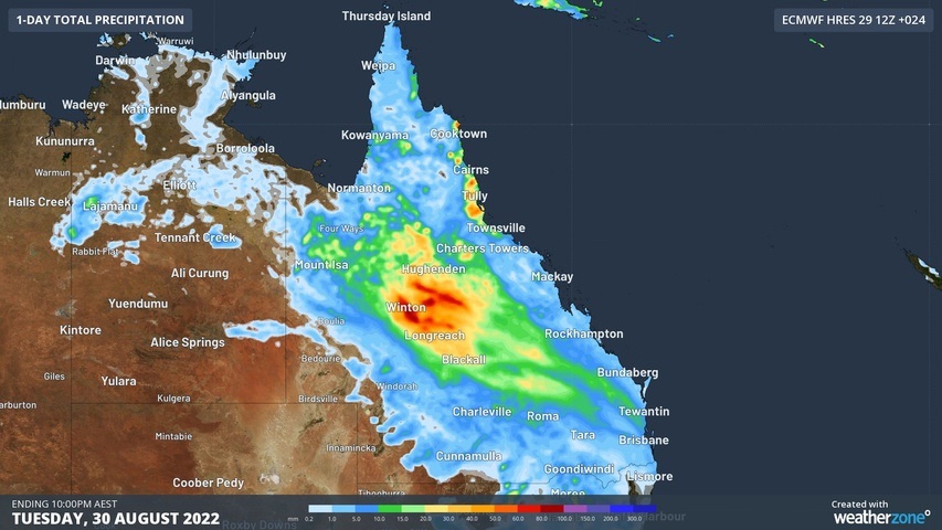
Unseasonably heavy rain will continue to spread further east across central inland QLD on Tuesday, before drier weather returns to most of the state on Wednesday.

Image: Forecast accumulated rain during the 24 hours ending at 10pm AEST on Tuesday, August 30, 2022.

Another band of cloud and rain will spread across QLD on Thursday and Friday, bringing more wet weather to the state’s outback in the opening days of spring. For more information on Weatherzone’s rainfall forecasting and alerting, please contact us at apac.sales@dtn.com.

Latest news

Satisfy your weather obsession with these news headlines from around the nation, and the world.

El Niño Is Here: What a Potential Record Event Means for Southeast Asia and Australia

  El Niño was officially declared in June 2026, raising the prospect of widespread impacts across Southeast Asia, from extreme heat and water shortages to higher energy demand and agricultural stress.   The World Meteorological Organization has warned countries to “prepare for it to be severe”, while several global forecast models suggest the event could rank among […]

How El Niño will shape Australian port operations in winter-spring 2026

Australian ports and marine pilots can expect a season of shifting wind and swell patterns through winter and spring 2026, as a developing El Niño brings the likelihood of drier conditions and more variable operating windows across the country’s coastline.  Will El Niño develop in 2026?  There are clear signs that an El Niño pattern is becoming […]

From Kimberley to northern NSW: Bushfire outlook flags risk for resources sector this winter

Bushfire risk doesn’t usually make headlines in June, but AFAC’s winter seasonal outlook is putting mining and resources operators on alert from the Kimberley to the NSW.  Australia’s official seasonal bushfire outlook for winter 2026 was released by AFAC on Thursday, May 28. The outlook predicts increased fire risk across the northern parts of the Great Sandy Desert and surrounds […]

The signal was there weeks earlier: forecasting one of the year’s biggest wind events

In mid-May 2026, DTN APAC meteorologists flagged a strengthening Southern Ocean pattern in model guidance, signalling an extended run of record-challenging wind conditions across the NEM.  Nearly three weeks later, NEM wind generation climbed from around 1.5GW to more than 9GW, supplying roughly one-third of the grid and coming within 1GW of the all-time generation record.  The event highlighted […]