Large areas of inland Australia are being warned of above-average fire activity early next year as prolific vegetation growth caused by this year’s flooding rain starts to dry out towards the end of summer.
The Australian Fire and Emergency Service Authorities Council (AFAC) released the Summer 2022 Seasonal Bushfire Outlook for Australia on Tuesday. This outlook is developed by AFAC in consultation with the Bureau of Meteorology and fire and emergency services from each state and territory.
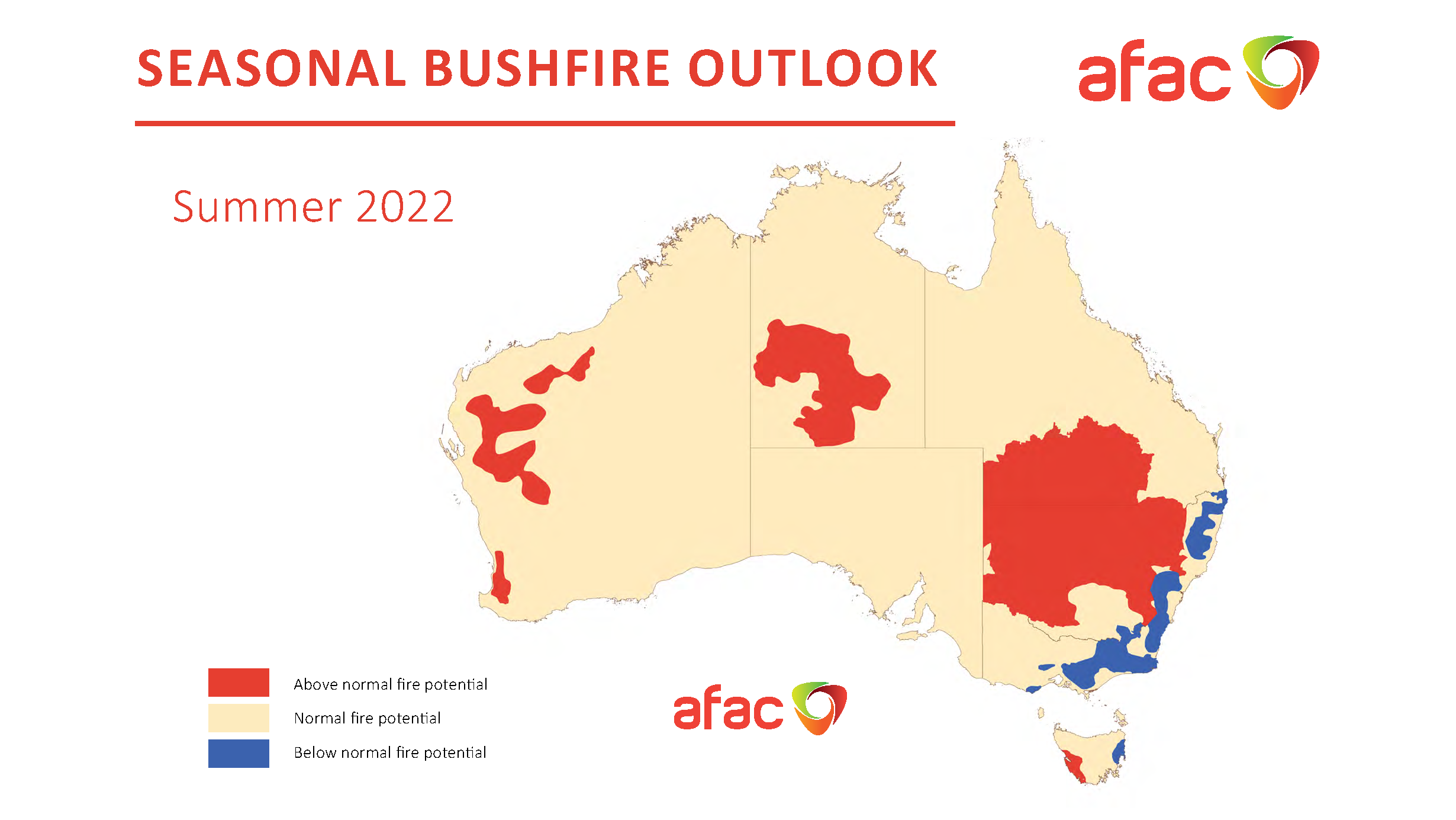
The map below shows the Summer 2022 outlook for Australia, revealing a mix of above and below normal fire potential across the country.

Image: Australia’s Seasonal Bushfire Outlook for summer 2022. Source: AFAC
Vast areas of red shading stand out on the map, highlighting regions that have the potential to see above-normal fire activity this summer. These red blotches cover much of the Murray-Darling Basin, inland areas of central and western Australia, and small pockets of southwestern Australia and western Tasmania.
It may come as a surprise to see above-normal fire potential predicted in parts of Australia that are currently experiencing significant flooding. In fact, some areas have seen so much rain in recent months that flooding can still be seen clearly from space.
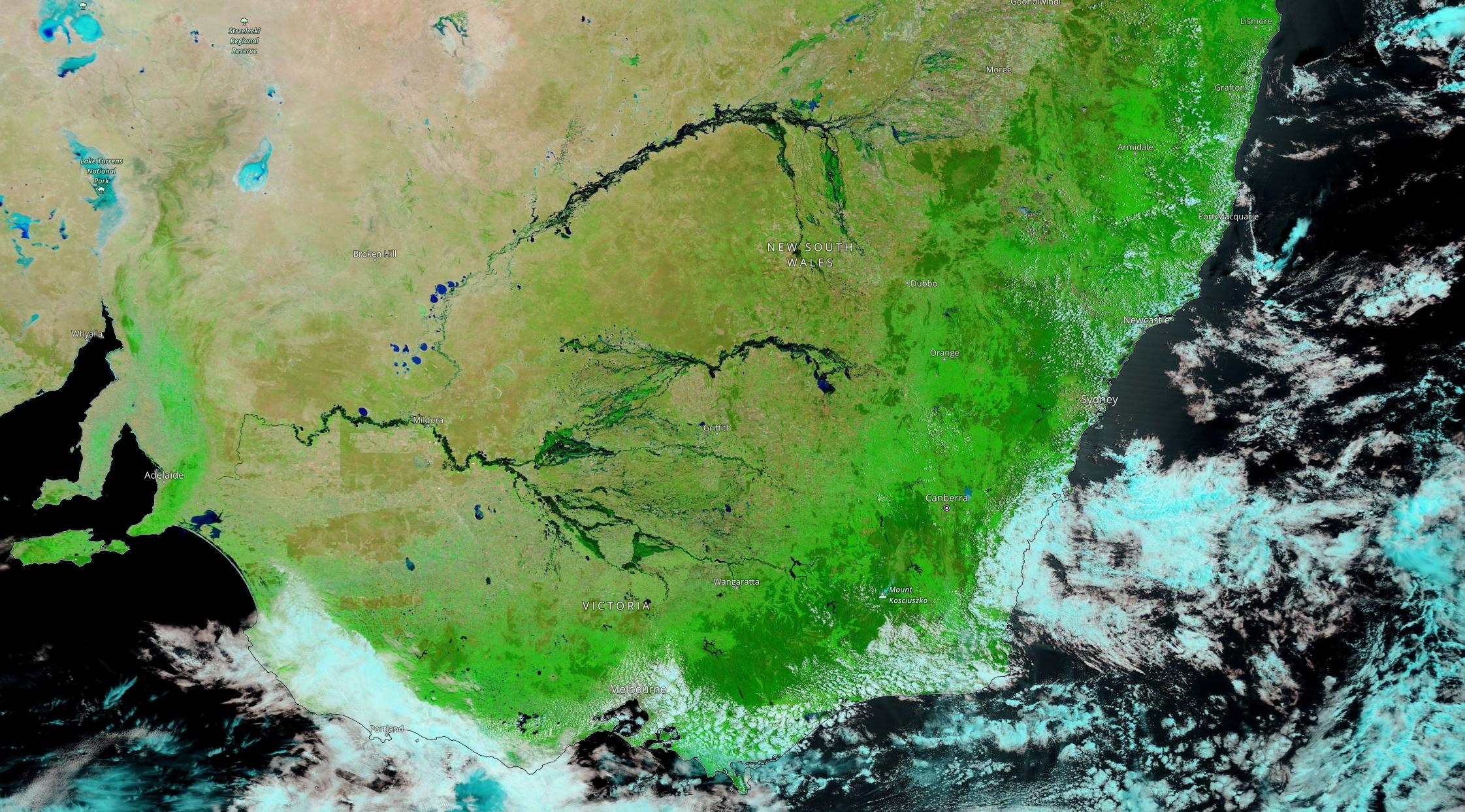
Image: Enhanced visible satellite image captured by NASA’s TERRA satellite on November 25, 2022, showing extensive flooding across the Murray-Darling Basin. Source: NASA
But while the water currently sitting in and on the ground will help suppress fires at the start of summer, the enhanced grass and crop growth off the back of this year’s rain may provide extra fuel for fires towards the end of the season.
Over Australia’s eastern inland, the AFAC outlook notes that “early summer fire activity is expected to remain below normal in flood affected regions.
“However with an expected return to more normal rainfall conditions over summer, these grass fuels are likely to cure and become more susceptible to fire.
“This will result in an above average fire potential later in summer, with the chance of exceeding average fire danger in grassland areas increasing towards the end of the quarter.”
By contrast, forested areas of eastern NSW, the ACT and central and eastern Vic are likely to see below-normal fire potential this summer. This is due to lower fuel loads in the wake of the 2019/20 Black Summer fires and better retention of soil moisture in these forests.
Large areas of central and western Australia (including Perth) also have increased potential for fires this summer. This is thanks to expected warmer-than-average temperatures drying out the vegetation that has grown in response to recent rain.
Fire danger in Tasmania is expected to be lower than normal in the state’s east thanks to recent and ongoing rainfall. However, an extended period of below-average rain in the state’s west may increase fire risk this summer.
AFAC notes that “above normal fire potential is anticipated in western Tasmania as the flammability of peat soils, moorlands, scrubs, and heaths is predicted to be greater than normal. Lightning strikes in these areas may ignite fires which may be difficult to control.”
Fires can happen at any time during summer, even in areas that are not expected to have an above-normal fire season. Be sure to stay up to date with the latest fire weather warnings throughout summer and check you state or territory’s fire and emergency services page for the latest information on current fire activity.
DTN APAC actively forecasts and alerts for bushfires and grass fires across Australia. We have access to hourly Fire Behaviour Index (FBI) that you can view on your dashboard up to a week in advanced, helping you to plan.
Current fires and hotspots are also alerted, including their location relative to your assets, so you can get on top of them before they become a major threat. To find out more, email us at apac.sales@dtn.com.


