
Large areas of Australia could be in for an unusually dry and warm autumn as La Niña loses its grip on our weather.
The latest seasonal outlook from the Bureau of Meteorology shows significant potential for below average rain and above average daytime temperatures for most of Australia this autumn.
.png)
.png)
Images: Chance of exceeding the median rainfall (top map) and maximum temperature (bottom map) during autumn 2023. Source: Bureau of Meteorology
By contrast to the daytime warmth that is being predicted in the coming months, overnight temperatures are tipped to be near-to-below average for some areas, particularly in the interior.
.png)
Image: Chance of exceeding the median minimum temperature during autumn 2023. Source: Bureau of Meteorology
One of the main drivers behind this dry and warm outlook is the breakdown of La Niña in the Pacific Ocean. La Niña typically causes above average rain and cloud in Australia. In its absence, our weather has a better chance of being drier, warmer during the day, and cooler at night.
La Niña helped cause record-breaking rain and flooding in parts of eastern Australia in 2022. However, ocean temperatures in the Pacific Ocean have now returned to a neutral state and the atmosphere, which is still in a La Niña-like state, is also expected to transition into a neutral phase in the coming weeks.
Video: Sea surface temperature anomalies in the Pacific Ocean on February 22, 2023. The breakdown of La Niña’s oceanic signal in the Pacific Ocean over the last three months. Source: NOAA
Once La Niña has officially ended, forecast models suggest that the Pacific Ocean will either remain in a neutral state throughout autumn and into winter, or possibly transition towards an El Niña phase around the middle of 2023.
On the other side of the country, the Indian Ocean Dipole is also expected to be either neutral or positive during the next 3 to 6 months. A positive IOD usually causes dry and warm weather in Australia, like El Niño.
AUSTRALIA AT RISK OF WORST GRASS FIRES IN 49 YEARS, REPORT WARNS
However, it is important to note that seasonal outlook models have less accuracy at this time of year and become more reliable after autumn.
Australia weather during autumn 2023 will also be affected by the background influence of climate change, which has generally caused temperatures to rise in recent decades. Some parts of the country have warmed by more than half a degree in the past 50 years.
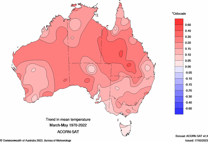
Image: Change in mean temperatures across Australia between 1970 and 2022. Source: Bureau of Meteorology.
The seasonal outlook maps shown near the top of this article are based on the best forecast information available right now. However, the accuracy of long-range models will improve as we get closer to the middle of 2023.
We will provide regular updates on Australia’s seasonal outlooks on the Weatherzone News Page in the coming months.
DTN APAC can provide tailored climate briefings to your business to alert you of the most likely weather conditions and hazards to look out for during the upcoming season. Now is a good time to get a good look at the forecast for autumn and an early look at winter. To find out more or to book a presentation, please email at apac.sales@dtn.com.


