
A deepening Tasman Low will bring damaging winds and surf along a broad area of the NSW coast during the next 24 to 48 hours.
The satellite image below shows the low pressure system sitting around 280 kilometers off the northern NSW coast at 11am AEDT Thursday, March 31.

This low pressure system was partly responsible for the heavy rain and renewed flooding across parts of northern and southeast QLD earlier this week. While this rain is now easing as the low moves offshore, powerful southerly winds and large waves will remain a threat for at least the next 48 hours.
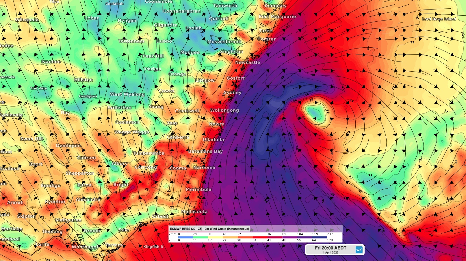
Southeasterly winds will strengthen along the NSW coast during Thursday evening into Friday, with winds likely peaking on Friday as the low deepens and moves closer to the state’s central coast. The maps below show both average 10-minute winds and instantaneous wind gusts on Friday night, with powerful winds expected to develop over a large area of the NSW coast and adjacent ranges, along with parts of Victoria.


Images: ECMWF forecast 10 metre average wind speed (top) and wind gusts (bottom) at 8pm AEDT on Friday, April 1.
Damaging winds gusts may peak at around 100km/h over eastern NSW between Wooli and Newcastle overnight Thursday, before extending southward in eastern NSW and eastern Vic during Friday morning. Average 10-minute winds may peak at around 50-60km/h on Friday in these areas.
These winds may be strong enough to bring down trees in the rain-softened soil. Winds are likely to remain strong over the weekend but should ease below damaging strength on Saturday.
In addition to the damaging winds, damaging surf is expected to develop along the central and southern NSW coast on Thursday afternoon and persist into Friday.
The map below shows the wave heights near the shore reaching around 4-5 metres late on Friday, April 1. The damaging surf should persist into Saturday before gradually easing over the weekend

Image: Wave Watch III significant wave height forecast for 11pm Friday, April 1.
Coastal erosion is possible with this impending swell, particularly along the south facing beaches as the heavy surf combines with abnormally high tides
Severe weather warnings have been issued for damaging winds, damagin surf and abnormally high tides in NSW, and for damaging winds in Vic. These warnings will be updated over the next few days. . Our meteorologists will continue to watch this system as it evolves in the next 48 hours. For more information please contact us at apac.sales@dtn.com.




