
Prosper in a dynamic world
Search

Brisbane’s coldest July in over 30 years


Brisbane is on track to register its coldest July in more than 30 years based on daytime temperatures, as southern QLD braces for another cold snap in the coming days.

Southeast QLD has been unusually cold this month thanks to frequent burst of cold air travelling up from the Southern Ocean, and a few days of thick clouds and persistent rain.

Brisbane’s two coldest days of this month were July 4th and 5th, which only reached 14.2ºC and 14.0ºC respectively. These maximum temperatures were well below the city’s long-term average of 22ºC and were its coldest pair of days since 1956.

As of 5pm on July 26, only five days of this month had exceeded the city’s long-term July average of 22ºC.

Based on the observed temperatures up to 5pm on July 26 and the forecasts for the rest of the month, Brisbane is on track to have a monthly average maximum temperature of around 19.9ºC. This would be Brisbane’s coolest July since at least 1989 based on daytime temperatures.

The rest of this week will also be noticeably cold over a broad area of southern and central QLD as a cold air mass spreads across the state from the south.
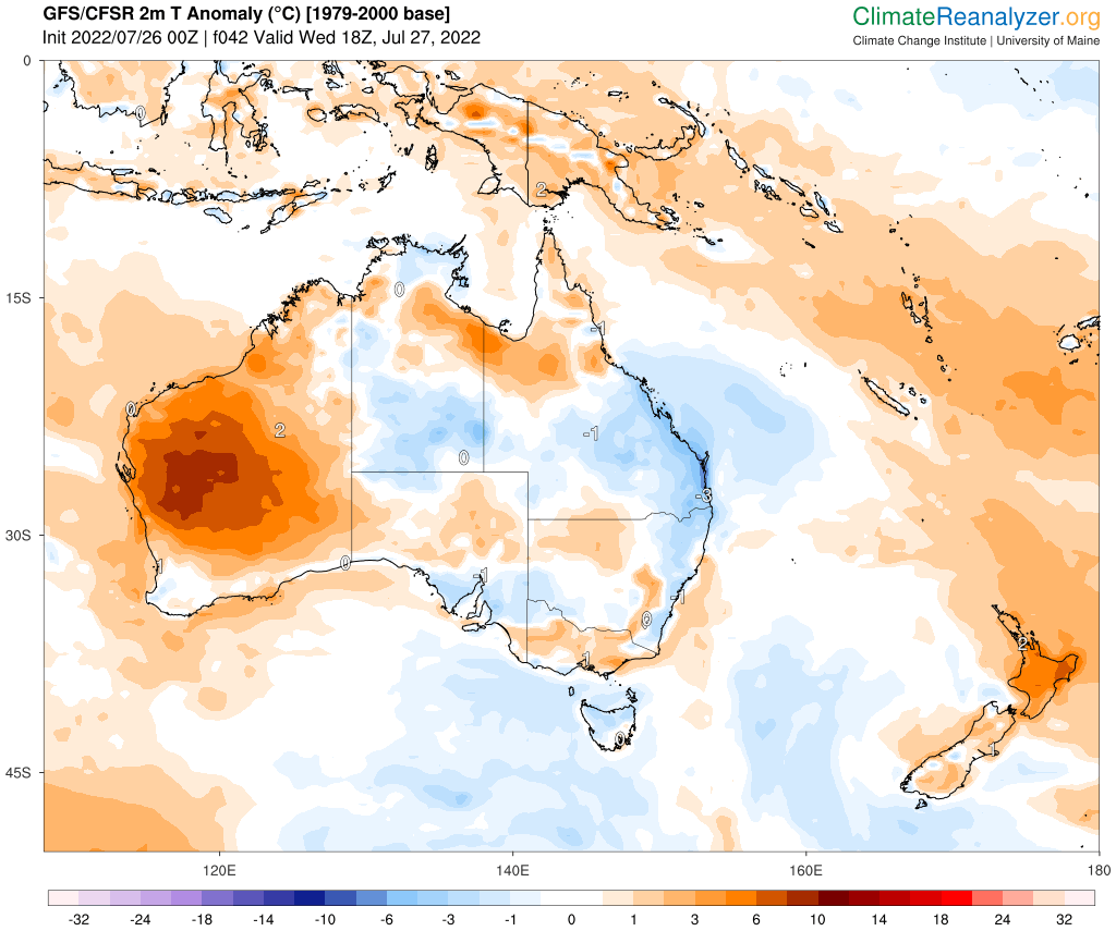
Image: Predicted surface air temperature anomaly on Thursday morning, according to the GFS model. Source: ClimateReanalyzer.org

The combination of this cold air with clear skies and light winds will allow morning frost to develop over parts of southern inland QLD from Wednesday to Saturday. During this cold snap, temperatures in Stanthorpe could dip to around -1ºC to -2ºC for four to five mornings in a row. For more information, please contact us at apac.sales@dtn.com.


Latest news

Satisfy your weather obsession with these news headlines from around the nation, and the world.

A warm, light wind spring ahead for the NEM

A strong El Niño and an unusually stable Antarctic polar vortex are setting up a spring signal of light winds, elevated solar output, and a real risk of high-intensity heatwaves for the NEM.   This forecast could be a major flip to what the National Electricity Market (NEM) has experienced so far during Winter 2026. On 1 July 2026, the NEM […]

Habagat and successive typhoons trigger widespread flooding in the Philippines

Three consecutive weeks of enhanced southwest monsoon (Habagat) and back-to-back typhoons have flooded Luzon and the Visayas, grounding flights, triggering distribution power outages, cutting off transport corridors, and raising landslide risk across mining-dense provinces like Benguet and the Cordillera. The disruption is far from over with PAGASA expecting the monsoon to remain in place until […]

Australia’s Spring 2026 Bushfire Outlook: Increased Risk Across Seven States and Territories

Fire agencies, land managers and businesses are being urged to prepare as the AFAC spring seasonal bushfire outlook, released on August 19, 2026, warns of elevated bushfire risk across Australia this season. The outlook identifies above-average fire danger across seven states and territories, with conditions driven by a combination of elevated fuel loads, an El Niño […]

Businesses under pressure: how this powerful high will affect Australian industries

A very strong high pressure system centred over Tasmania will impact southern and eastern Australia’s weather over the coming days. How strong is this high pressure system? Mean Sea Level Pressure (MSLP) has already reached 1039.3 hPa at Ouse, Tasmania on Sunday morning, and is forecast to peak at 1041 or 1042 hPa on Monday […]

