
Weatherzone and its coastal engineering partner Baird Australia, have analysed the unique meteorological and wave conditions of the weekend’s East Coast Low and how they contributed to the coastal flooding and erosion observed along the NSW coastline. Beaches such as Narrabeen and Collaroy are known erosion ‘hot-spots’ but have not been subjected to beach erosion of the scale currently being experienced since the storms of the mid-1970s.
The East Coast Low of May 1974 is often referred to as the ‘Sygna storm’ due to the grounding of the MV Sygna ship at Stockton Beach near Newcastle.
Significant (average) wave heights during the Sygna storm exceeded those of the most recent event (9+ metres versus 7 metres) but there were reasons why coastal impacts were similar for the two events.
The most recent event was notable due to a large swathe of gale to storm-force northeast winds that developed between the deepening east coast low and a strong high pressure system over New Zealand. This ‘fetch’ of northeast winds extended approximately 1500km from the Coral Sea to the NSW coast (see image), helping the swell to build in both size and strength. The size and duration of this fetch is also the reason that large swells have persisted along the Sydney coastline through Monday and Tuesday even after the low has long since passed to the south of NSW.
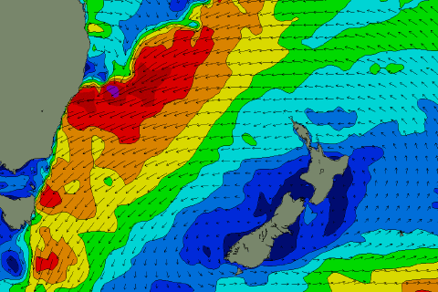
On Sunday it was the proximity of the low (and some of the strongest winds) to the NSW coast that added to the size and frequency of waves seen near Sydney, whilst also contributing to a storm surge of up to 30 centimetres above the predicted astronomical tide.
A storm surge is caused by strong winds blowing onto the shore from the ocean, and low atmospheric pressure, both of which raise the sea level above the expected astronomical tide level (strong onshore winds ‘pile up’ water against the coast, while a 1hPa atmospheric pressure drop roughly equates to a 1cm increase in local sea level).
This astronomical tide on Sunday evening was predicted to be the highest of the 2016 (without meteorological influences), with a listed height of 2.05 metres (this is most correctly labelled a ‘perigean spring tide’ but colloquially known in Australia as a ‘king tide’). With the addition of the 25cm storm surge to this height, and the action of the 7 metre swell from the northeast, extensive coastal erosion was the result, most notably around Collaroy and Narrabeen.
The astronomical tide on Monday evening was listed at 2.04 metres (second highest of 2016), so even without the influence of a storm surge on this day there was the potential for further erosion of coastal property as large swells persisted from the northeast.
Detailed computer models comparing the weekend storm to the May 1974 Sygna storm shed light on why the lower wave height event on Sunday generated erosion of the magnitude observed by larger historical events. Baird Australia’s managing director, David Taylor, noted the unique nature this recent event. “The storm tracked down from Southeast Queensland along the coastal fringe, meaning the largest waves arrived from a north-easterly direction. The track of the low (and its proximity to the NSW coast) contributed to relatively large shoreline wave heights at beaches such as Collaroy that are more exposed to waves originating from north-east to east directions offshore. The north-east to easterly waves observed over the weekend are the largest ever recorded from those directions offshore of Sydney, which has one of the most extensive long-term records of directional waves in the world.”
Computer modelling using Baird Australia’s high resolution model of the whole NSW coastline (see image below) demonstrated that waves from the north-east to east sector propagate onto parts of the Sydney coast with up to 25% greater height than waves arriving from the southeasterly quadrant, meaning that the nearshore wave heights were comparable with the 1974 event.
The two key common features between the May 1974 and June 2016 events that contributed to the high erosion rates observed at Narrabeen and Collaroy were similar peak surf zone wave heights close to the coast, and the largest waves occurred at the same time as water levels that exceeded the highest predicted tides. This resulted in erosion occurring closer to property boundaries along the beach.




