Prosper in a dynamic world
Search

222 mm in three hours triggers flash flooding in NSW, QLD

Parts of northeast NSW and southeast QLD were inundated by torrential rain on Thursday night, with some places collecting more than 300 mm during a barrage of thunderstorms.

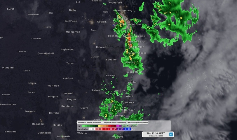
A deepening low pressure system interacting with copious moisture and an unstable atmosphere produced a sustained period of heavy rain and thunderstorms over northeast NSW and southeast QLD on Thursday night into Friday morning.

The heaviest rain occurred in the hinterland region near the QLD/NSW border, where near-stationary thunderstorms delivered several hours of torrential rain that caused flash flooding.

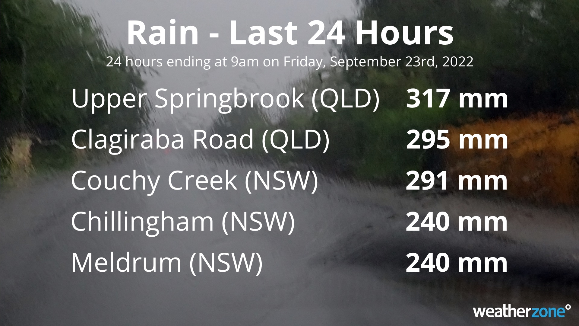
Rain gauges at Upper Springbrook in QLD and Couchy Creek in NSW collected a whopping 222 mm in just three hours late on Thursday night. By 9am on Friday, Couchy Creek had amassed 291 mm during the past 24 hours and Upper Springbrook had collected 317 mm.

Another rain gauge near Clagiraba in QLD received 104 mm in just one hour on Thursday night.

This intense rainfall caused minor to moderate flooding in some areas and triggered numerous warnings for flooding, heavy rain and severe thunderstorms.

Heavy rain and storms will remain a threat in northeast NSW and southeast QLD on Friday morning, before rain eases into the afternoon as the low pressure system moves offshore.

This weather system has also caused flooding over other areas of NSW and southern QLD during the last two to three days. Check the latest warnings for the most up-to-date information on current and future flooding.

For more information on our products or how we can help you with your business needs, please contact us at apac.sales@dtn.com

Latest news

Satisfy your weather obsession with these news headlines from around the nation, and the world.

El Niño Is Here: What a Potential Record Event Means for Southeast Asia and Australia

  El Niño was officially declared in June 2026, raising the prospect of widespread impacts across Southeast Asia, from extreme heat and water shortages to higher energy demand and agricultural stress.   The World Meteorological Organization has warned countries to “prepare for it to be severe”, while several global forecast models suggest the event could rank among […]

How El Niño will shape Australian port operations in winter-spring 2026

Australian ports and marine pilots can expect a season of shifting wind and swell patterns through winter and spring 2026, as a developing El Niño brings the likelihood of drier conditions and more variable operating windows across the country’s coastline.  Will El Niño develop in 2026?  There are clear signs that an El Niño pattern is becoming […]

From Kimberley to northern NSW: Bushfire outlook flags risk for resources sector this winter

Bushfire risk doesn’t usually make headlines in June, but AFAC’s winter seasonal outlook is putting mining and resources operators on alert from the Kimberley to the NSW.  Australia’s official seasonal bushfire outlook for winter 2026 was released by AFAC on Thursday, May 28. The outlook predicts increased fire risk across the northern parts of the Great Sandy Desert and surrounds […]

The signal was there weeks earlier: forecasting one of the year’s biggest wind events

In mid-May 2026, DTN APAC meteorologists flagged a strengthening Southern Ocean pattern in model guidance, signalling an extended run of record-challenging wind conditions across the NEM.  Nearly three weeks later, NEM wind generation climbed from around 1.5GW to more than 9GW, supplying roughly one-third of the grid and coming within 1GW of the all-time generation record.  The event highlighted […]