
It was dry across Australia in October, but Western Australia did it tougher than the rest, with its driest October on record.
- Nationally, it was Australia’s 5th-driest October since national records began to be kept in 1900.
- It was also the 5th-driest October in South Australia, the 6th-driest in the Northern Territory, and the 12th-driest in Queensland.
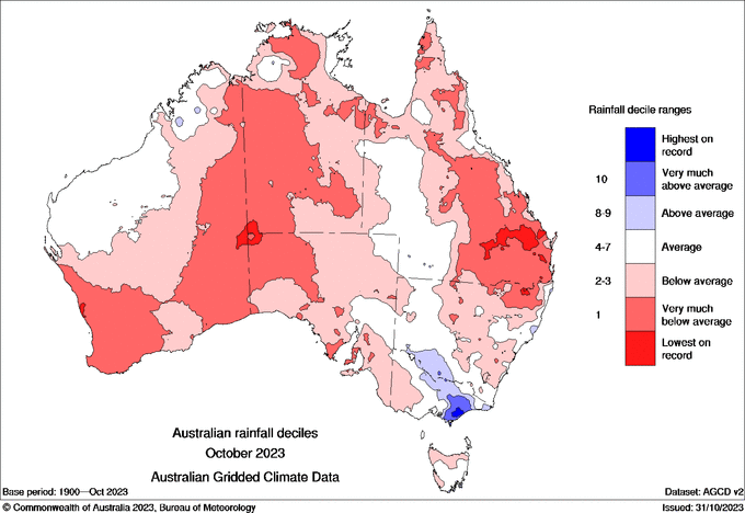
Image: Rainfall deciles for Australia in October 2023. Source: BoM.
The map above tells the tale. Of the eight states and territories, only Victoria had slightly-above-average rainfall for the state as a whole – with 8% more rain than the long-term average.
That was mainly due to a few active cold fronts in the state’s south, and one particularly heavy rainfall event in the first week of the month which caused severe flooding in parts of Gippsland and minor-to-moderate flooding elsewhere.
The main other rain event worth mentioning was one heavy night of rain on parts of the NSW Mid North Coast (indicated by a small blue zone on the map).
Otherwise, the rest of the country saw few newsworthy rain events and as mentioned, Western Australia suffered the biggest shortfall, due in large part to the positive Indian Ocean Dipole.
READ MORE: Positive IOD keeps getting stronger
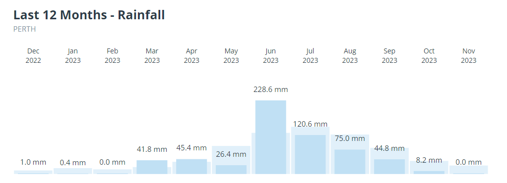
Take a look at the graph below. It shows how Perth endured its fourth month in a row of significantly below-average rainfall, with 8.2 mm of rain compared to its October average of 39.7 mm.
And Perth was far from alone in being parched in October.
- Normally soggy Albany in the state’s South Coastal forecast district had 23.2 mm compared to its October average of 78.2 mm
- Geraldton in the state’s Central West forecast district had just 1.2 mm compared to its October average of 18.9 mm.
- Kalgoorlie in the Goldfields district had 0.6 mm compared to its October average of 15.8 mm
The fact that Perth, Albany, Geraldton, and Kalgoorlie all had major rainfall deficiencies indicates how dry the southern half of the state was in October 2023. In most cases, the rainfall deficiencies were ongoing from about July too. That’s not good news as we head into the usually dry summer in WA’s south.
Meanwhile Perth is heading for a dry, windy day with a top of 37°C this Friday, which would be the hottest day of spring 2023 to date. For more information on Weatherzone’s rainfall and climate driver forecasts and presentations, please contact us at apac.sales@dtn.com.
READ MORE: ‘Australia’s hottest place’ almost 6 degrees above average in October


