
An outbreak of severe thunderstorms will develop across much of WA during the middle of this week, with the potential for damaging winds and unseasonably cold and wet conditions following it.
This dynamic thunderstorm period will be generated by a low pressure trough sitting across western WA and a deep low pressure system which will increase activity on Wednesday as it moves over the state.
Thunderstorms should begin on Tuesday over the Pilbara, Kimberley, Gascoyne, Goldfields and the South West Land Division on Tuesday in response to the low pressure trough.
Thunderstorms will become widespread and severe stretching from the Pilbara down to the Eucla and Esperance coasts on Wednesday, as the low impacts the state.
The map below shows the Convective Available Potential Energy (CAPE) or a measure of atmospheric instability on Wednesday. Meteorologists use CAPE values to determine how much energy is available for developing thunderstorms. Higher values of CAPE show the potential for greater atmospheric instability increasing the potential for storms to grow.

Images: Convective Available Potential Energy (CAPE) in J/kg at 5pm AWST on Wednesday, October 2, according to ECMWF.
In the image above you can see values of 1200 J/Kg near and offshore the Pilbara coast and around 800 J/Kg pockets in WA’s interior stretching to the southeastern coast. These values show the potential for large and potentially severe thunderstorms on Wednesday.
Due to the increased winds across all levels of the atmosphere, the most likely phenomenon the state could see is damaging to locally destructive winds associated with these thunderstorms.
The thunderstorms and rain will bring some decent rainfall to WA’s interior and southwest WA in during the next three days, with widespread falls of 15 to 30mm forecast and isolated falls between 30 to 60mm.
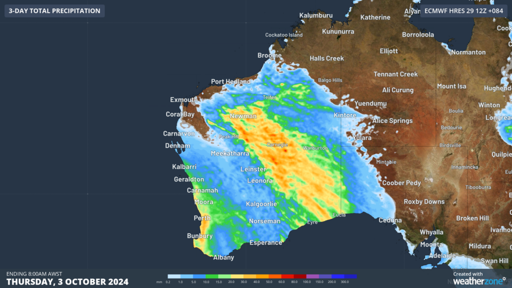
Image: Accumulated rain for the three days leading up to 8am AWST on Thursday, October 3, according to ECMWF.
Ahead of the rain and thunderstorm activity WA is set to see temperatures reaching the high 20s to low 30s, before a frigid airmass arrives on Wednesday behind the low.
The map below shows the contrasting airmasses on Wednesday afternoon with the cold airmass surging over the state’s southwest and the warm air in the north.
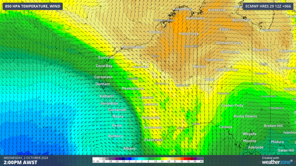
Image: 850 hPa temperature and wind at 2pm on Wednesday, October 2, according to ECMWF.
This airmass will cause Perth’s daytime temperatures to drop from around 6°C above average on Tuesday to around 4°C below average on Wednesday and Thursday, with 17 to 18°C forecast.
The blusterous westerly winds will also make the temperature feel like around 6°C later on Wednesday into Thursday. These winds will also whip up some large waves across the west and south of the state on Wednesday and Thursday.
The thunderstorms and rain should ease on Thursday as the low moves east out of state, however temperatures should remain cool across the southwest until later in the week.
As this system unfolds, please keep an eye out for the latest forecasts and warnings.
Embedded in DTN APAC’ industry interfaces, the system gives you a time advantage when monitoring conditions developing over your infrastructure and location.
Stormtracker is our Global Information System (GIS) tracking tool, providing multiple weather layers and zoom controls overlaid on a map of your location and infrastructure. You can choose a snapshot or full screen view, depending on your requirements. The maps allow you to monitor all weather, and specifically any systems likely to cause risk for your business. You also have the capacity to observe:
- real time lightning and thunderstorm alerts
- localised lightning strike frequency
- official warnings for storm, cyclone, wind, flood and fire
- sentinel hotspot fires and fire agency current incidents
Stormtracker’s radar imagery updates every 10 minutes, so you are always able to respond rapidly to changing conditions. You can customise alerting to notify you when your staff or infrastructure are under threat. With increased situational awareness, your ability to make informed decisions quickly is optimised.
DTN APAC’ experience and intelligence gives you a clear path through complex situations. Let us assist you, offering actionab le insight when extreme weather poses risk to your business. For more information, please visit our website or email us at apac.sales@dtn.com.


