Prosper in a dynamic world
Search

Storms soak Red Centre, Eastern Australia next in line

Rain and thunderstorms have been soaking Australia’s Red Centre this week, with Alice Springs picking up more than a month’s worth of rain last night.

A broad area of low pressure interacting with a moisture-laden air mass has produced several days of wet and stormy weather in central Australia this week.

Earlier in the week, grey clouds and storms swept across the Uluru-Kata Tjuta National Park, providing a unique opportunity to witness lightning and rain around Uluru.

Storms. Red Centre. Eastern Australia

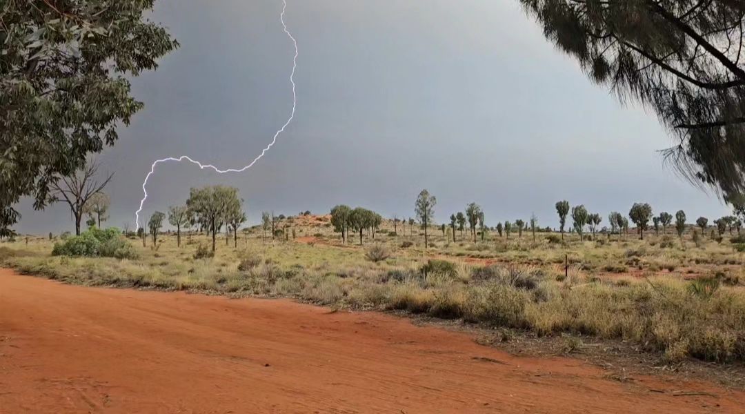
Image: Lightning near Uluru earlier this week. Source: @jestopher.palmer / Instagram

The wet and stormy weather then spread further north and east on Thursday into Friday, allowing intense storms to pass over Alice Springs.

The rain gauge at Alice Springs Airport received 36 mm of rain between 11pm Thursday and 7:30am Friday. This is 4mm more than its November monthly average and its highest daily total in 10 months.

Total Lightning Network detected just over 50,000 lightning strikes within 200 km of Alice Springs during the 12 hours ending at 10am ACST on Friday.

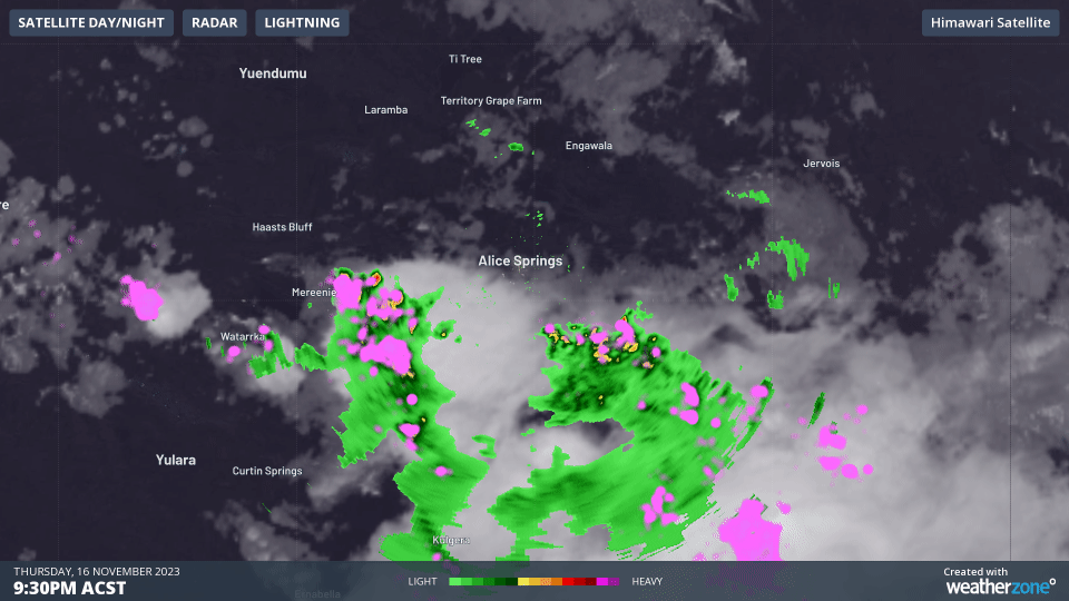
Video: Storms passing over Alice Springs on Thursday night.

This week’s storms in central Australia are part of a more widespread outbreak of late-spring thunderstorms that has been causing issues in other parts of the country.

Intense thunderstorms in WA’s Wheatbelt on Tuesday caused an unwelcome burst of heavy rain and hail, which damaged crops and disrupted harvest operations in the region.

Rain and storms will continue over central Australia on Friday and Saturday, before the focus of the wet and stormy weather spreads to the country’s east and north.

Some forecast models suggest that rain and thunderstorms could linger over eastern and northern Australia through most of next week, increasing the risk of heavy multi-day rainfall and flooding. The map below shows how much rain one forecast model is predicting during the next seven days combined.

Storms. Red Centre. Eastern Australia

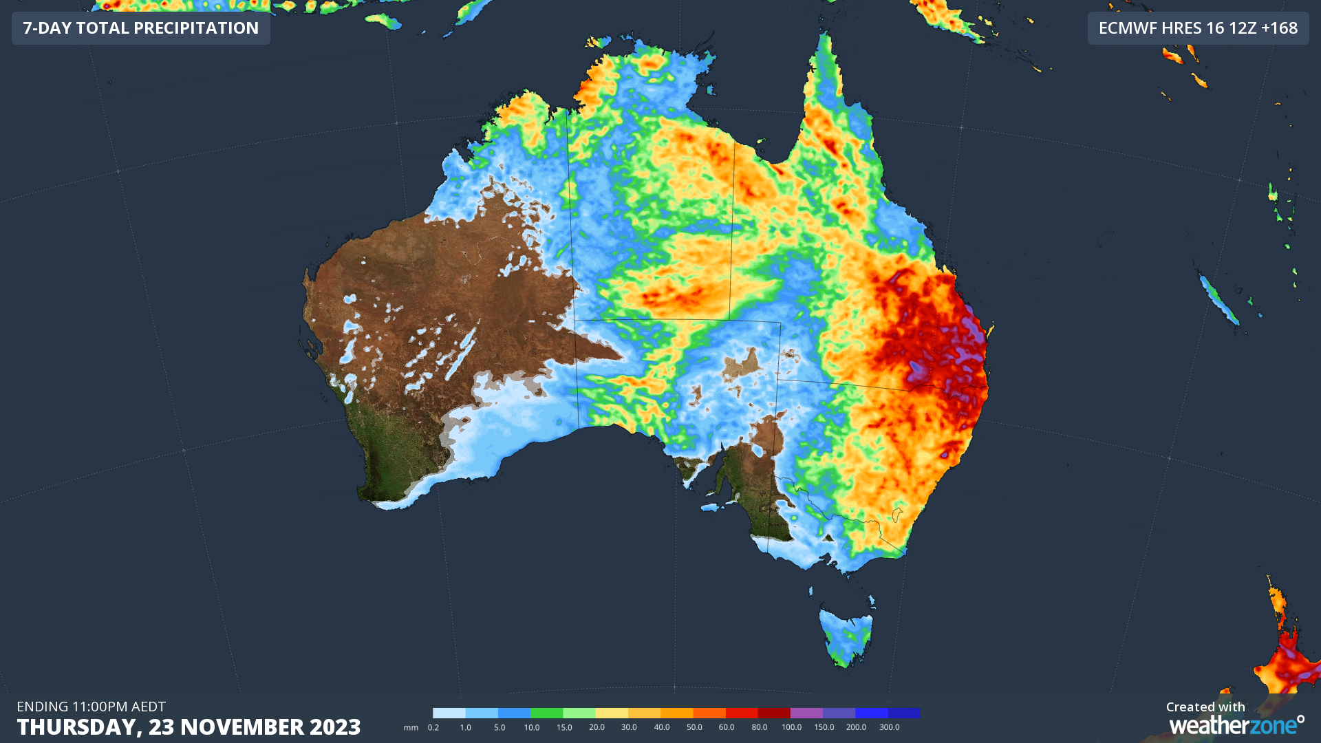
Image: Forecast accumulated rain during the week ending on Thursday, November 23, 2023, according to the ECMWF-HRES model.

For more information on our Total Lightning Network please contact us at apac.sales@dtn.com.

Latest news

Satisfy your weather obsession with these news headlines from around the nation, and the world.

Rapid El Niño signal accelerating risk for Australian businesses

El Niño–favourable conditions are gathering pace across the tropical Pacific, with key ocean indicators approaching threshold levels and early atmospheric responses emerging.  While uncertainty remains around final El Niño strength, historical analogues show that even weak events can generate widespread impacts, including reduced rainfall, warmer daytime temperatures, increased frost risk, elevated fire danger, reduced tropical cyclone activity, and more. Industries including […]

Australia’s 2025–26 Cyclone Season: Slightly Above Average, Dominated by Severe Systems

Australia has just experienced a highly impactful tropical cyclone season, with more than 60% of systems reaching severe intensity, causing widespread disruption and damage to communities and multiple industries across northern Australia.  The 2025–26 Australian tropical cyclone season officially ran from 1 November 2025 to 30 April 2026. During this six-month period, Australia saw 11 tropical cyclones, with nine […]

What does a ‘super El Niño’ mean for Australia’s businesses?

There are signs that a very strong, or ‘super’ El Niño could develop in the tropical Pacific Ocean later this year. So, what does this mean for Australia’s weather during the second half of 2026? El Niño on the horizon The tropical Pacific Ocean is currently in a neutral state, meaning neither El Niño nor […]

How does DTN help businesses monitor bushfire induced pyrocumulonimbus thunderstorms that ignite more fires?

Intense heat from bushfires during elevated fire danger days can trigger fire-induced pyrocumulonimbus thunderstorms that ignite additional fires. In early January 2026, an extreme heatwave sweeping over southeastern Australia brought catastrophic fire danger to Victoria. Intensely hot bush and grass fires spread erratically and quickly in hot, dry and gusty winds, with pyrocumulonimbus generating lightning, […]