Prosper in a dynamic world
Search

Pilbara bracing for second soaking in one week


Heavy rain will soak parts of WA’s Pilbara and Interior over the next two to three days, bringing a risk of flooding for the second time in one week.

A deepening low pressure trough being fed with a stream of tropical moisture caused a cloudband to develop over northwestern Australia on Tuesday morning.

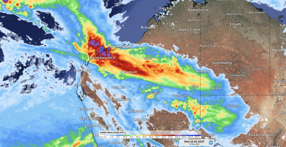
Rain from this developing cloudband is likely to become heavy over the Pilbara on Tuesday morning, before heavy falls spread further inland across the Interior later on Tuesday and Wednesday.

Accumulated rainfall totals of 50 to 150 mm are possible in parts the Pilbara by the end of Tuesday, while falls of 20 to 40 mm could amass over the Interior by Wednesday night. This may include six-hourly rain rates of around 60 to 120 mm in parts of the Pilbara, enough to cause flash flooding.

Image: Forecast accumulated rain between Monday and Wednesday this week, according to the ECMWF model.

Some of this week’s heavy rain will fall across an area that picked up more than 50 mm late last week, further increasing the risk of flooding.

A severe weather warning and flood watch have been issued for parts of the Pilbara and Interior in response to this developing system. Be sure to check the latest warnings for the most up-to-date information. For more information on Weatherzone’s heavy rainfall alerts and forecasting for mining, please contact us at apac.sales@dtn.com.

Latest news

Satisfy your weather obsession with these news headlines from around the nation, and the world.

Rapid El Niño signal accelerating risk for Australian businesses

El Niño–favourable conditions are gathering pace across the tropical Pacific, with key ocean indicators approaching threshold levels and early atmospheric responses emerging.  While uncertainty remains around final El Niño strength, historical analogues show that even weak events can generate widespread impacts, including reduced rainfall, warmer daytime temperatures, increased frost risk, elevated fire danger, reduced tropical cyclone activity, and more. Industries including […]

Australia’s 2025–26 Cyclone Season: Slightly Above Average, Dominated by Severe Systems

Australia has just experienced a highly impactful tropical cyclone season, with more than 60% of systems reaching severe intensity, causing widespread disruption and damage to communities and multiple industries across northern Australia.  The 2025–26 Australian tropical cyclone season officially ran from 1 November 2025 to 30 April 2026. During this six-month period, Australia saw 11 tropical cyclones, with nine […]

What does a ‘super El Niño’ mean for Australia’s businesses?

There are signs that a very strong, or ‘super’ El Niño could develop in the tropical Pacific Ocean later this year. So, what does this mean for Australia’s weather during the second half of 2026? El Niño on the horizon The tropical Pacific Ocean is currently in a neutral state, meaning neither El Niño nor […]

How does DTN help businesses monitor bushfire induced pyrocumulonimbus thunderstorms that ignite more fires?

Intense heat from bushfires during elevated fire danger days can trigger fire-induced pyrocumulonimbus thunderstorms that ignite additional fires. In early January 2026, an extreme heatwave sweeping over southeastern Australia brought catastrophic fire danger to Victoria. Intensely hot bush and grass fires spread erratically and quickly in hot, dry and gusty winds, with pyrocumulonimbus generating lightning, […]