Prosper in a dynamic world
Search

Dry season floods threaten northern Aus this week

Unseasonably heavy rain and flooding could cut off roads in the Kimberley and central Australia this week.

The satellite images below show a large northwest cloudband extending across Australia on Monday morning. This colossal cloudband, which is being fuelled by tropical moisture from the Indian Ocean, will produce widespread rain over a broad area of Australia this week.

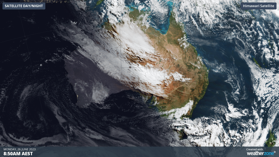
Image: Himawari-9 satellite images showing a northwest cloudband extending over Australia on Monday, June 26, 2023.

The heaviest rain on Monday and Tuesday will fall over the Kimberley and Interior of WA, and over the Western Interior of the NT. The map below shows the predicted rain during these two days combined.

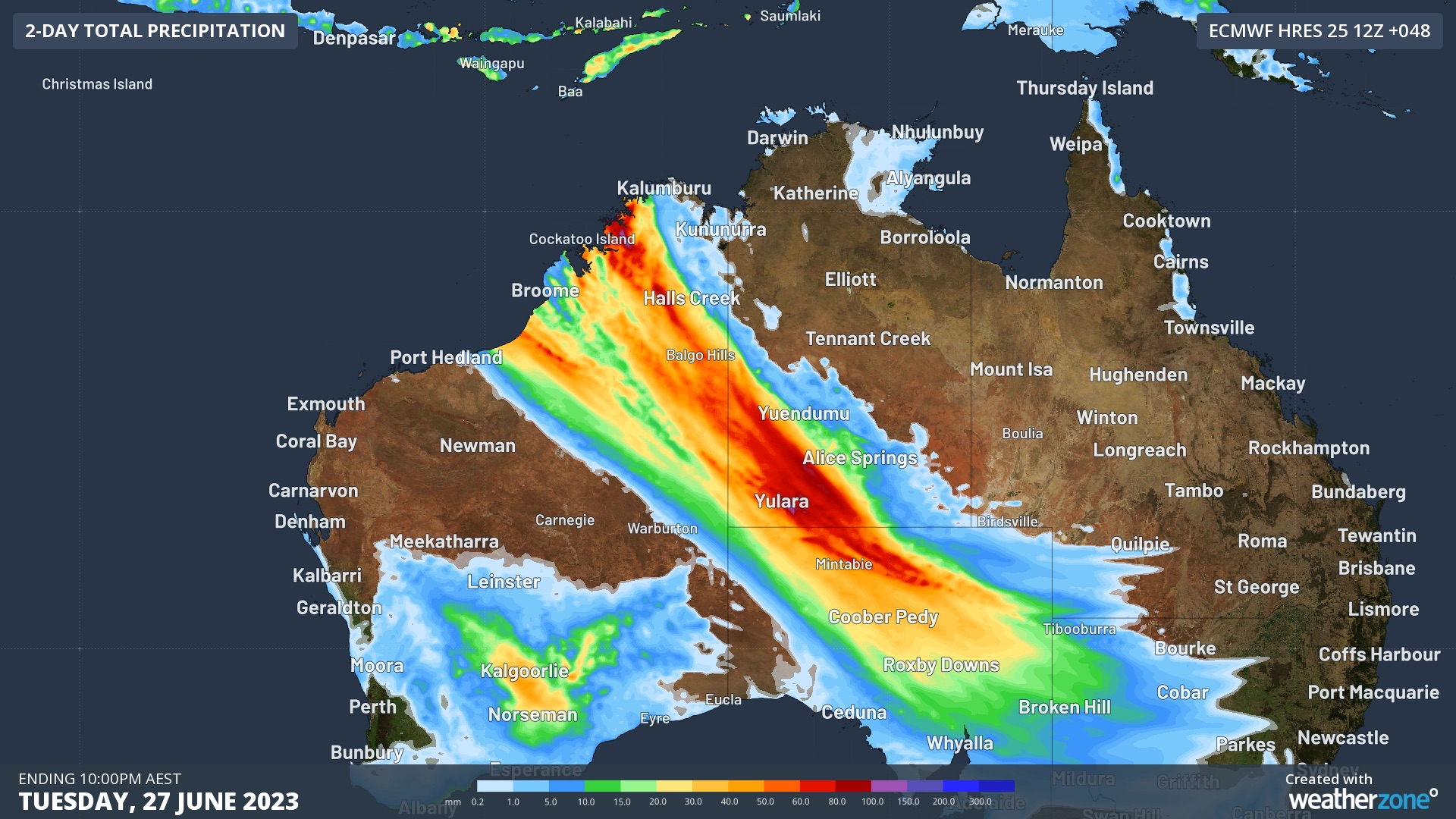
Image: Forecast accumulated rain during the 48 hours ending at 10pm AEST on Tuesday, June 27, 2023.

Flood Watches have already been issued in both states, with some road closures also announced in the Kimberley for the coming days. These include the Gibb River Road, which will close from Tuesday, and Fitzroy Crossing Bridge, which may close later in the week.

On Wednesday, rain will continue over parts of central and northwestern Australia and spread into the nation’s southeast as well.

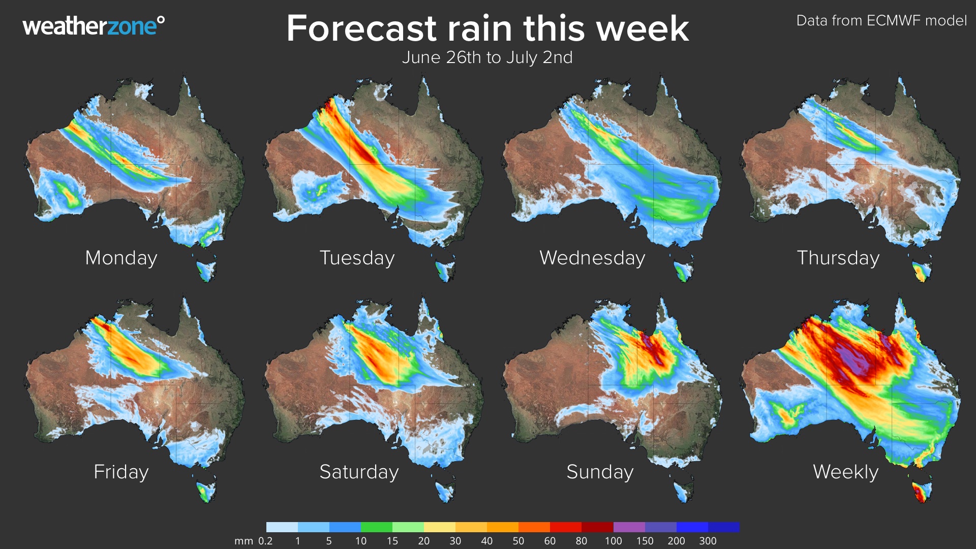
Later in the week, a second round of heavy rain is expected to develop over the Kimberley and NT from Friday, before spreading towards the east and affecting Qld on the weekend and possibly into the start of next week.

Image: Forecast daily rainfall this week, according to the ECMWF-HRES model.

This system will deliver widespread and prolonged rainfall to parts of Australia that typically see little of no rain at this time of year. This will cause out-of-season flooding and may catch some communities and travellers by surprise.

Be sure to check the latest warnings and road closures before travelling across the Australian outback in the next couple of weeks.

DTN APAC has heavy rainfall and flooding alerts to help you keep track and prioritise assets that require attention. To find out more, please email us at apac.sales@dtn.com.

Latest news

Satisfy your weather obsession with these news headlines from around the nation, and the world.

Rapid El Niño signal accelerating risk for Australian businesses

El Niño–favourable conditions are gathering pace across the tropical Pacific, with key ocean indicators approaching threshold levels and early atmospheric responses emerging.  While uncertainty remains around final El Niño strength, historical analogues show that even weak events can generate widespread impacts, including reduced rainfall, warmer daytime temperatures, increased frost risk, elevated fire danger, reduced tropical cyclone activity, and more. Industries including […]

Australia’s 2025–26 Cyclone Season: Slightly Above Average, Dominated by Severe Systems

Australia has just experienced a highly impactful tropical cyclone season, with more than 60% of systems reaching severe intensity, causing widespread disruption and damage to communities and multiple industries across northern Australia.  The 2025–26 Australian tropical cyclone season officially ran from 1 November 2025 to 30 April 2026. During this six-month period, Australia saw 11 tropical cyclones, with nine […]

What does a ‘super El Niño’ mean for Australia’s businesses?

There are signs that a very strong, or ‘super’ El Niño could develop in the tropical Pacific Ocean later this year. So, what does this mean for Australia’s weather during the second half of 2026? El Niño on the horizon The tropical Pacific Ocean is currently in a neutral state, meaning neither El Niño nor […]

How does DTN help businesses monitor bushfire induced pyrocumulonimbus thunderstorms that ignite more fires?

Intense heat from bushfires during elevated fire danger days can trigger fire-induced pyrocumulonimbus thunderstorms that ignite additional fires. In early January 2026, an extreme heatwave sweeping over southeastern Australia brought catastrophic fire danger to Victoria. Intensely hot bush and grass fires spread erratically and quickly in hot, dry and gusty winds, with pyrocumulonimbus generating lightning, […]