Darwin just registered its wettest July in 23 years, although it’s unlikely a single umbrella was raised throughout the month.
July marks the middle of the NT’s dry season, which runs from May to September and typically includes periods of weeks to months without any rainfall in Darwin. This long spell of low rainfall occurs because the monsoon moves to the north of Australia through the middle of the year, causing drier southeasterly winds to dominate over the NT’s Top End. For operations in Northern Australia, monitoring these seasonal transitions and unseasonable rain events with professional weather tools for mining sector efficiency is vital for maintaining site safety and logistics.
Darwin’s long-term average rainfall in the entire dry season is 43.7 mm and July is usually the city’s driest month, with a long-term monthly average of just 1.1 mm. By comparison, Sydney’s July average is close to 100 mm.
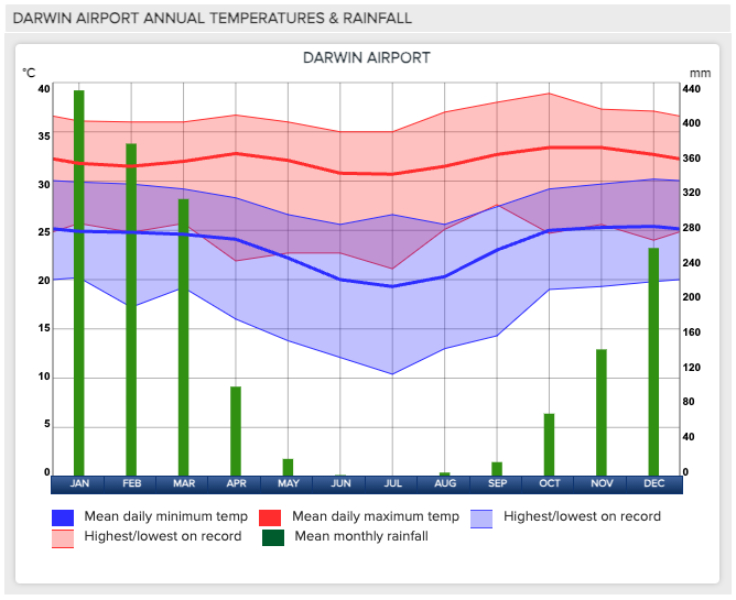
Image: Darwin’s monthly rainfall and temperature climatology.
This July was a very wet month by local standards. Despite only collecting 2.4 mm in the entire month, Darwin doubled its monthly average rainfall and registered its wettest July in 23 years.
The sight of this much rain is rare in Darwin during July and some might consider it lucky to be soaked by a couple of millimetres at this time of year. Unfortunately, most of last month’s rain (2.2 mm) fell on a single Thursday night, while most people were in bed.
Despite most locals sleeping through the rare dry season rain last month, it was still enough to make this Darwin’s wettest July since 2001. It was also the first time in 23 years Darwin registered more than one day of rain during July.
Perhaps unsurprisingly, this was far from Darwin’s wettest July on record. The city’s old Post Office weather station once recorded 65 mm of rain in a single July, way back in 1900.
Looking ahead, Darwin has no rain on the forecast for the opening week of August and that will most likely be the story for most of the month. On average, Darwin usually records rain on one day every second August.
Miningzone, by DTN APAC, is the only weather tracking and alerting solution purpose-built for the resources sector.
As the climate shifts into unchartered territory, weather events could affect your mine with increasing force.
Miningzone is the proven and trusted turnkey solution –deployed at over 400 mines globally – offering you tailored forecasting and alerting systems to protect your valuable staff and assets.
Weatherzone’s integrated services are intuitive and user-friendly, providing you with the specific weather and blast data needed to gain a complete environmental picture.
You will have access to our lightning and severe weather tracking and alerts, EPA-approved blast dispersion modelling, thunderstorm tracking and high precision and site-specific forecasting, along with comprehensive reporting capacity.
Precise, market-leading data is delivered via multiple platforms including Weatherguard – our easy-to-use app – and can be fully integrated into your operational control or SCADA systems.
To find out more, please visit our contact page or email us at apac.sales@dtn.com.


