We all know that Darwin experiences an extended dry season through the middle months of the year, but the 2023 dry season was a lot drier than most.
- Indeed, Darwin received a grand total of no rainfall in this year’s dry season, which officially runs from May through September according to the BoM.
- Darwin also saw a run of 161 rainless days from April 28 through October 5, 2023 – the longest dry spell in 15 years since the 167-day rainless streak in 2008
Take a look at the 2023 dry season rainfall in the Top End in the graphic below.
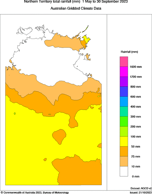
Source: BoM.
The area in white translates to a region roughly half the size of Victoria which saw absolutely no rain, and while it’s not the first time this has been recorded, it is nonetheless quite rare.
Even when Top End rain taps turn off during the southern winter, there are usually a few drips, with the odd shower or two always a possibility in the dry months.
For example, Darwin’s average monthly rainfall from May to September is:
- May 20.2 mm
- June 1.8 mm
- July 1.1 mm
- August 4.6 mm
- September 16.3 mm
The worrying news for Top Enders in need of a good soaking is that there’s no strong indication of an imminent end to the dry weather in sight.
Even though Darwin’s October average monthly rainfall is 71.2 mm, just one day of rain has been recorded in October 2023 to date. That was 1.6 mm back on October 6 and there’s nothing significant in the forecast for the next week.
We know that a positive Indian Ocean Dipole (IOD) tends to mean a later-than-usual onset of the wet season, while an El Niño (as we have now) is also a contributor to a later onset.
If there’s a faint pointer to an outbreak of afternoon showers and thunderstorms in coming weeks, it’s that the latest IOD index published on October 22 saw a tiny drop after its recent steep, dramatic climb – though not by much.
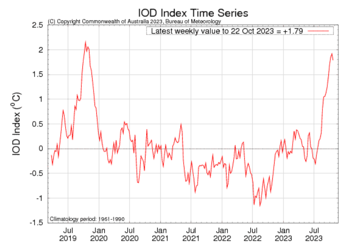
Source: BoM.
For more information on our wet season and tropical cyclone forecasts and presentations, please contact us at apac.sales@dtn.com.


