
Rain, wind and waves are intensifying along the north coast of NSW as a low pressure system starts to form off the coast.
An upper-level trough passing over NSW has caused widespread rain over eastern Australia during last couple of days.
The heaviest rain during the 24 hours to 9am on Friday fell along the NSW Mid North Coast, where Comboyne Public School received 124 mm and Mooral Creek collected 121 mm. Falls of 50-60mm were also recorded in Coffs Harbour and parts of Sydney.
Wind and waves have been increasing along the NSW coast over the last 24 hours in response to a powerful southerly chance in the wake of a low pressure trough.
Coffs Harbour registered a wind gust of 78 km/h shortly after 9am on Friday, while gusts exceeding 80km/h were also recorded in parts of the Hunter and near Sydney earlier in the morning.
These powerful southerly winds caused waves to bulge along the coast, with maximum wave heights reaching 8.6 metres near Coffs Harbour and 8.3 metres at Crowdy Head on Friday morning.
Looking ahead, a low pressure system is likely to develop off the north coast of NSW on Friday and linger into Saturday. This deepening low will cause wind, rain and waves to intensify further along the state’s northeast coast and in far southeast Qld.
Some forecast models predict 100 to 200 mm of rain over parts of northeast NSW during Friday and Saturday combined, which would be enough rain to cause flooding.
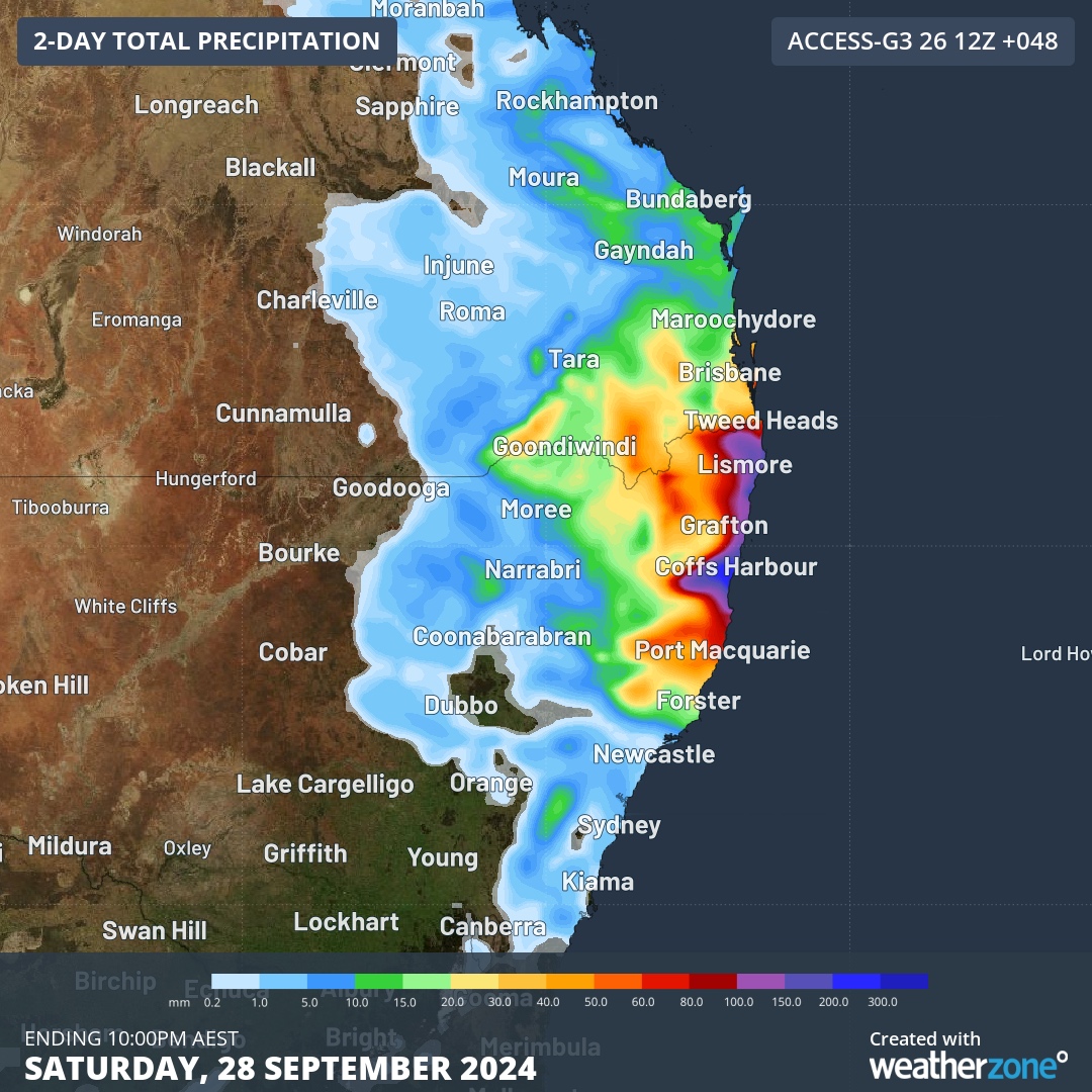
Image: Forecast accumulate rain on Friday and Saturday, according to the ACCESS-G model.
As of 10am AEST on Friday, a warning was in place for damaging surf between Port Macquarie in NSW and North Stradbroke Island in Qld. Other severe weather warnings may be issued during the next 24 hours as the low pressure system develops.
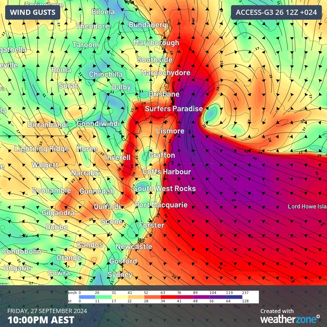
Image: Forecast wind gusts at 10pm AEST on Friday, according to the ACCESS-G model.
DTN APAC offers a comprehensive suite of services, refined through years of collaboration with the marine, ports and offshore industries, to optimise the safety and efficiency of your operations.
We work with you to understand your intrinsic operational challenges and customise high-precision forecasting, metocean and aviation services to your exact location and operational scope.
When working offshore, our solutions can underpin planning and safe execution for offshore oil and gas enterprises and wind farms. Our data can support your exploration, development, rig moving, shuttle tanker operations, and production and decommissioning phases. Whether your crews are on-site, being transported to shore, or diving to perform maintenance, we deliver tailored weather risk briefings to ensure you choose the optimal time to proceed.
Weatherzone’s trusted nowcasting and forecasting system, OpticastTM, allows you to rapidly respond to changing conditions offshore, en route and in port. We take your port topography and berth orientation into account, ensuring site-specific forecasts. For offshore oil & gas, wind farms, ports and logistics, we have your weather situational awareness covered, no matter where you are. We deliver real-time severe weather and lightning alerts to your team via your integrated dashboard: Portzone, and our Weatherguard app.
Weatherzone’s Total Lightning Network (TLN) ensures you avoid hours of unnecessary downtime by providing the most accurate technology in lightning detection and alerting. Safeguard your teams and assets with lighting and Dangerous Thunderstorm Alerts (DTAs), customised to your existing parameters and delivered in real-time across all devices in your network. You gain full spatial awareness of developing severe weather systems, allowing you to plan ahead and, where needed, execute your shutdown and evacuation procedures.
With extreme conditions slowing production and affecting infrastructure, safety and transport, trust us to deliver Australia’s most precise weather data and tailored insight, giving you decisive confidence when it’s most needed. For more information, please visit our website or email us at apac.sales@dtn.com.


