
Three consecutive weeks of enhanced southwest monsoon (Habagat) and back-to-back typhoons have flooded Luzon and the Visayas, grounding flights, triggering distribution power outages, cutting off transport corridors, and raising landslide risk across mining-dense provinces like Benguet and the Cordillera. The disruption is far from over with PAGASA expecting the monsoon to remain in place until the end of August, with El Niño and warm seas expected to enhance the impacts.
The image below shows vast cloud streaming over Luzon on Thursday, August 20, with the southwest monsoon remaining active over the region. Tropical Depression Neneng is tracking north-northwest toward Taiwan and is not expected to make landfall in the Philippines.
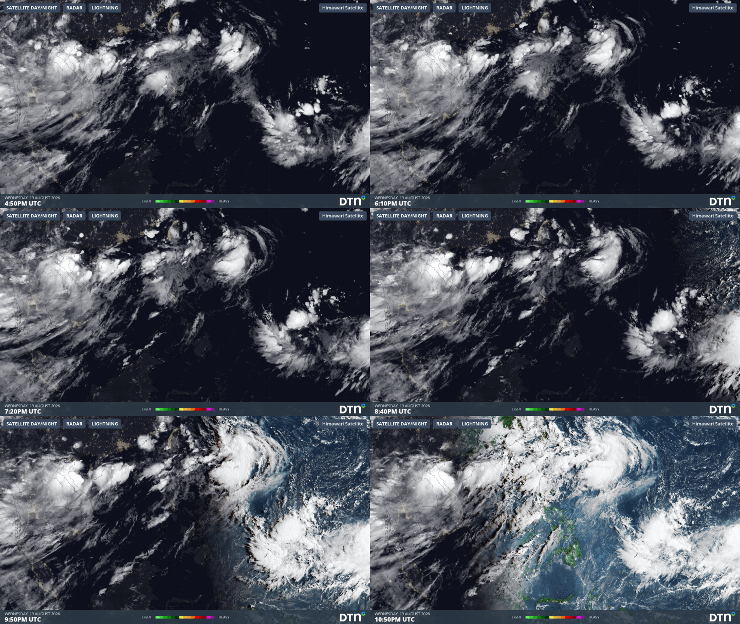
Image: Himawari Satellite Satellite/Radar/Lightning view over the Philippines, 19 August 2026, 4:50PM UTC. Source: DTN.
However, like Luis, Maymay and Dolphin earlier this month, Neneng’s circulation is pulling moisture into the monsoon, enhancing rainfall over the region. PAGASA is also monitoring two further systems outside its area of responsibility, including Tropical Storm Saudel to the east.
The enhanced Habagat is causing heavy rain and flooding across Metro Manila and parts of Luzon today, with further heavy showers and thunderstorms likely to maintain flood risk over the next few days.
What began in early August as a routine southwest monsoon surge compounded, storm on storm, into one of the country’s most damaging wet-season events in years.
August so far: three systems
The enhanced Habagat, back-to-back typhoons Luis and Maymay (internationally Kujira), and the outer moisture envelope of a genuinely historic Typhoon Dolphin passing well to the north are all responsible for the extremely wet August.
Tropical depression Luis (~2-4 August)
Luis made landfall in Isabela, drenching eastern and western Luzon with moderate to heavy rain and triggering gale warnings across several coastal provinces before weakening into a low-pressure area.
Tropical Storm Maymay / Kujira (~Aug 4–7)
Maymay made landfall in Ilocos Sur, crossing northern Luzon and killing at least six people, displacing nearly 7,000, and causing widespread flooding and landslides, while also amplifying the Habagat.
Super Typhoon Dolphin 2026 (7-10 August)
Typhoon Dolphin was a very strong category five system and set a record as the first storm of this strength to form the furthest east in the northwest Pacific. Dolphin spun up from a tropical depression to a Category 5-equivalent super typhoon in under four days over water that was 2 to 3°C warmer than the seasonal average, a rate of intensification that puts it among the fastest-strengthening storms on record for the basin.
The winds in the system peaked at 265km/h sustained winds on July 30-31, 2026, one of the most powerful storms of the season with 13-metre waves. The image below shows Dolphin Barrelling towards east Asia to the north of Tawain on August 9 with vast cloud over parts of the Philippines feeding directly into the southwest monsoon, adding fuel to a system that was already overloaded by Luis and Maymay. It absorbed the moisture of the smaller Kujira as it tracked west, brushed Okinawa on August 7, and made landfall on the China coast between Zhejiang and Fujian on August 9–10.
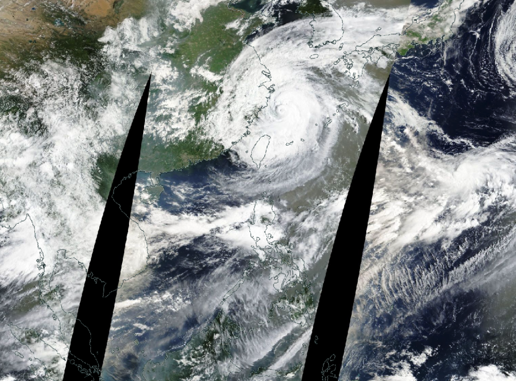
Image: NASA Worldview satellite imagery with Typhoon Dolphin passing to the north of the Philippines from August 9, 2026
While Dolphin never made direct landfall in the Philippines, its sheer size and power triggered floods, landslides and widespread disruption.
Tropical depression Neneng (~Aug 18–19)
Tropical depression Neneng formed in the Philippine Sea but is tracking toward Taiwan and not expected to make landfall in the Philippines, though it is drawing in the Habagat and extending monsoon rains likely through the end of August.
Why has August 2026 been so active?
The Philippines sits at the heart of the world’s most active typhoon basin, and August 2026 has been a particularly active month. Tropical Depression Luis, Tropical Storm Maymay, and Typhoon Dolphin struck in rapid succession within a single month, with each storm amplifying the southwest monsoon and delivering compounding waves of rainfall across Luzon. Maymay’s rains swelled rivers upstream of four dams in the Bulacan-Pampanga area, forcing emergency water releases into already-flooded communities. Driving this relentless parade of storms is an intensifying El Niño and anomalously warm sea surface temperatures which are feeding frequent tropical storm and typhoon activity.
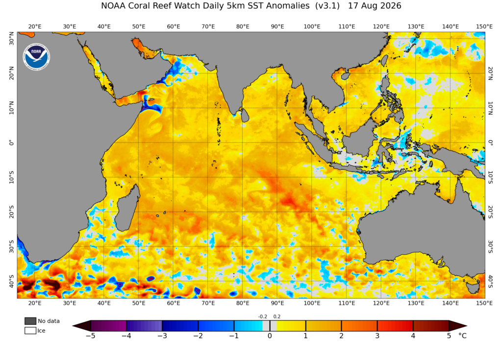
Image: Sea Surface temperature anomalies on August, 17, 2026. Source: NOAA
Impacts
The compounding meteorological events up till mid-to-late August have led to the following impacts:
- Deaths: Confirmed fatalities are at least 23 people, the majority in landslides in Benguet and Baguio City, with additional fatalities in Rizal, Batangas, La Union and Pangasinan from drowning, electrocution and rockslides.
- People affected: NDRRMC’s mid-August situation report put the number at roughly 4.8 million people across ten regions of Luzon and the Visayas.
- State of calamity: At least 50 cities and towns declared a state of calamity, with entire provinces such as Pampanga and Cavite placing every municipality under that status.
- Infrastructure damage: Roughly ₱2.65 billion PHP, largely to roads, bridges and flood-control assets.
- Agriculture: ₱1.42 billion PHP in losses across 34,572 hectares and more than 43,000 farmers, with rice absorbing well over half the damage.
- Aviation: Recurring multi-day disruption at NAIA—dozens of flights cancelled or diverted on August 6, 8, 9, 10, 18 and 19 alone, with CAAP logging go-arounds, missed approaches and thousands of stranded passengers each time visibility or crosswinds crossed operational thresholds.
- Ports and logistics: Hundreds of passengers, drivers and cargo workers stranded across dozens of seaports as interisland shipping was suspended.
Impacts to major industries across the Philippines
Aviation
NAIA’s repeated cycle of cancellations, diversions and go-arounds through August is a direct illustration of why generic forecasts fall short for airfield operations. The difference between a routine delay and a missed approach often comes down to hyperlocal visibility, crosswind and lightning data at the specific runway threshold, updated in near-real time.
Agriculture
Rice crops have taken a large hit, with Cordillera vegetable farmers forced to discard entire harvests as trading centres flooded and produce rotted before it could move. With a strong El Niño now developing, the risk can flip within a matter of months: from too much water to potentially too little, as the dry season that follows an El Niño onset tends to run hotter and drier than normal across much of the archipelago.
Benguet and the wider Cordillera mining regions are landslide prone. Saturated slopes, stressed tailings and waste-dump stability, and road-access failure to remote sites are a recurring risk signature in this terrain whenever rainfall like Baguio’s nine-day total occurs.
Beyond the aviation disruption, road and bridge damage cut off communities and slowed the movement of relief goods and commercial freight alike, while interisland ferry and cargo operations were repeatedly suspended for rough seas.
Downed trees and toppled utility poles caused outages in Zambales, Subic, Castillejos and San Antonio, a pattern that recurs across nearly every major habagat and typhoon event and complicates restoration timelines when access roads are also flooded or landslide blocked.
DTN Weather Hub for Airport Operations
The same complex, location-specific threat picture described in this analysis – typhoon rapid intensification, monsoon-driven visibility loss, crosswind events, and lightning – is precisely the operational environment DTN Weather Hub is built for.
Airport operators across the region rely on DTN APAC for hyperlocal airfield monitoring, configurable lightning and threshold alerts, role-based decision dashboards, and a defensible post-event record, all accessible by field teams on mobile. We provide:
- Lightning detection and alerting;
- Visibility and crosswind Intelligence;
- Hyperlocal airfield monitoring;
- Mobile access for field teams; and
- Post-event documentation.
When the weather signal is this complex, generic forecasts aren’t enough. DTN Weather Hub delivers the operational precision airports need to keep people and infrastructure safe. Reach out to our experts today at sales.apac@dtn.com for an exclusive demo.




