
The 2025 Indian Southwest Monsoon that brings cooler temperatures and heavy flooding rainfall to Indian transport, mining and utility industries completed its retreat from India on October 16, 2025.
As seen in the map below issued by the Indian Meteorological Department (IMD), the Indian Southwest Monsoon withdrew from the entirety of the Indian sub-continent on October 16, 2025 – one day later than the normal date of October 15. The conclusion of the monsoon typically signals the start of a new season of atmospheric activity, where monitoring oceanic shifts with advanced tropical cyclone tracker tools becomes essential for maintaining safety across the region.
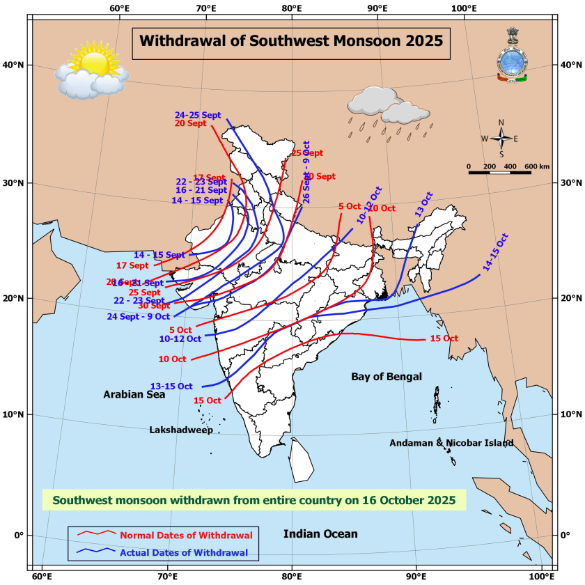
Image: Withdrawal of the 2025 Indian Southwest Monsoon (blue) compared to normal withdrawal dates (red). Source: IMD
The 2025 Indian Southwest Monsoon season
The Southwest Monsoon was first observed by the IMD over the south Andaman Sea and Nicobar Islands on May 13, 2025 – seven days ahead of the normal date of May 20. It then reached Kerala, in the far south of India around May 24, 2025 – eight days ahead of the normal date of June 1 – and covered the entire Indian sub-continent by June 29, 2025 – 16 days ahead of the normal date of July 15.
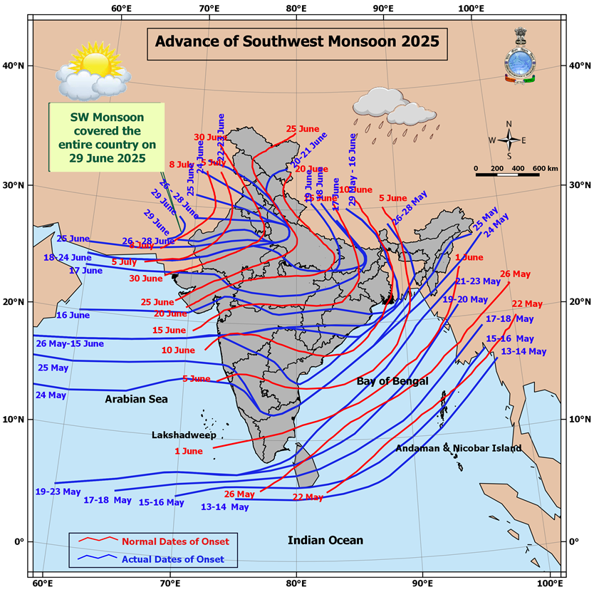
Image: Progress of the 2025 Indian Southwest Monsoon onset (blue) compared to normal onset dates (red). Source: IMD
As mentioned in previous DTN APAC articles, the southwest monsoon season featured heavy rain periods. As a result, the cumulative rainfall across the country throughout the season was 937.2mm, 107.9% of the long period average (LPA) of 868.6mm.
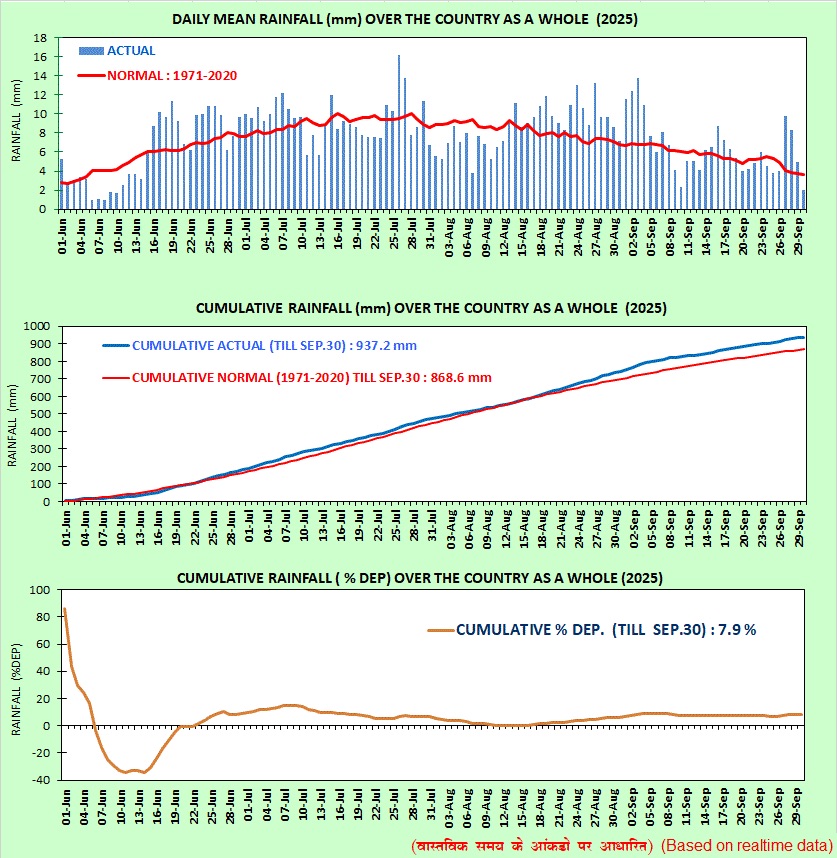
Image: Daily mean rainfall (top), cumulative rainfall (middle) and cumulative departure from the LPA for the entirety of India across the 2025 Indian Southwest Monsoon season. Source: IMD
Breaking down this country wide rainfall across India’s four homogenous sub-regions (% of the LPA):
- North West India: 127.3%
- East & Northeast India: 79.8%
- Central India: 115%
- South Peninsular: 109.9%
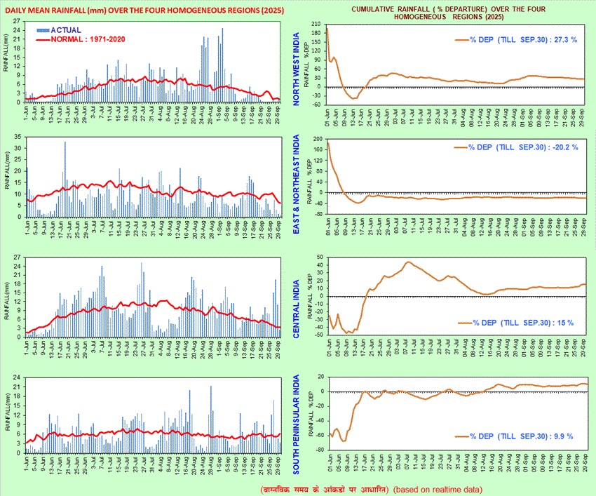
Image: Daily mean rainfall (left) and cumulative departure from LPA (right) across India’s four homogeneous regions during the 2025 Indian Southwest Monsoon season. Source: IMD
The 2025 Indian Southwest Monsoon began its withdrawal from the far northeast of the sub-continent on September 14, 2025 – 13 days behind the normal date of September 1 – and completed its withdrawal from India on October 16, 2025.
Comparison of the 2025 Indian Southwest Monsoon to previous years
This monsoon season’s rainfall of 108% the LPA marks the fifth of the past seven years seeing above average rainfall across the monsoon season. 2021 was near normal with 99% of the LPA, and 2023 was below average with 94% of the LPA.
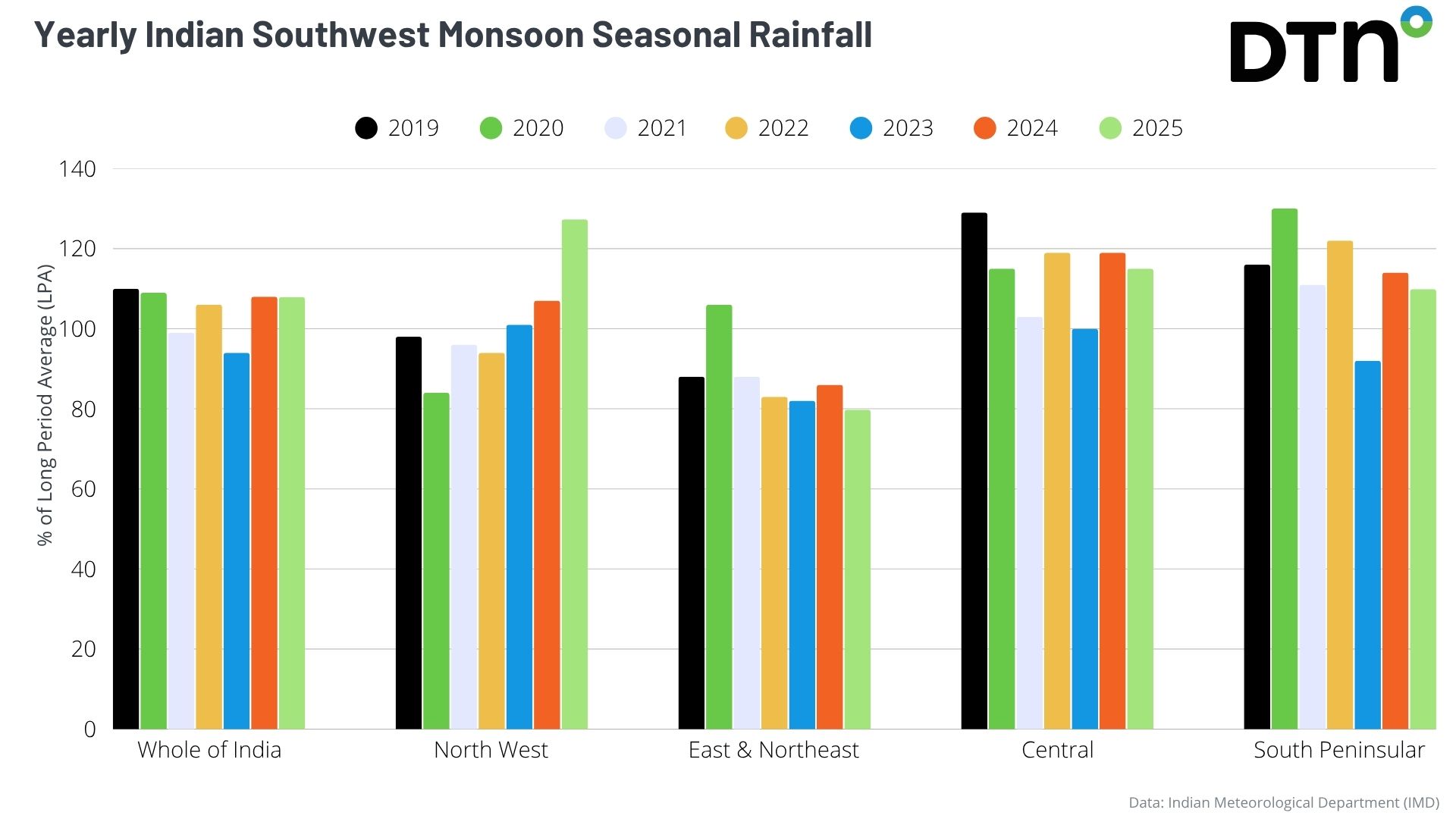
Image: Indian Southwest Monsoon rainfall (% of LPA) across India and the four homogeneous regions (North West, East & Northeast, Central and South Peninsular) across the past seven years. Data source: IMD
Notable trends across the past seven years include:
- Well above average rainfall across Central and South Peninsular regions
- Well below average rainfall (except 2020) for East & Northeast India
- Normal to above average rainfall for North West India
What’s next for India and it’s businesses and industries?
The withdrawal of the southwest monsoon from India over the past week has quickly been replaced by the northeast monsoon driving moist winds from the Bay of Bengal into eastern and southern India.
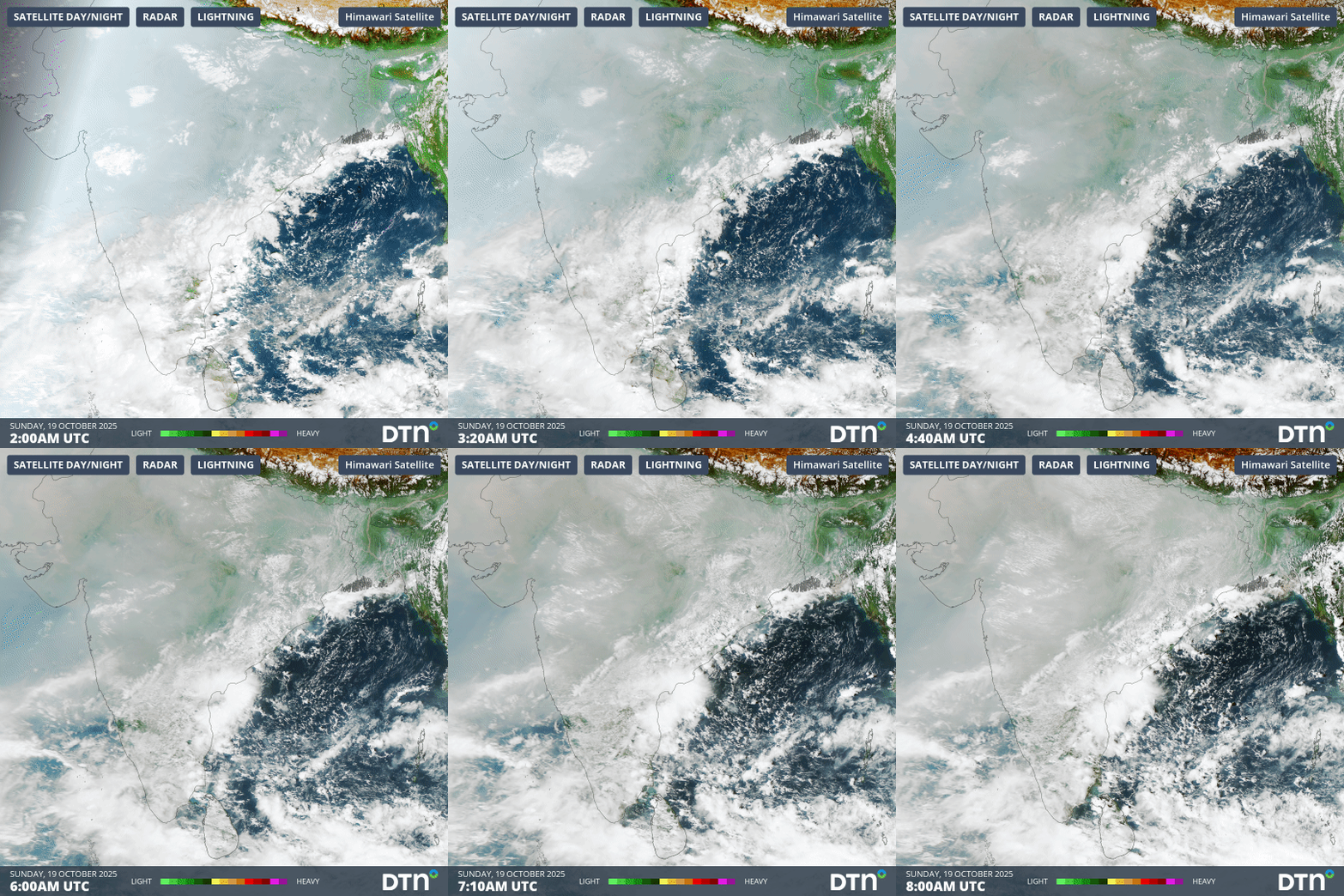
Image: Visible satellite imagery on Sunday, October 19, 2025 showing cloud cover moving into southern and eastern India with the northeast monsoon.
However, the northeast monsoon has much less widespread impacts rainfall and cloud cover across the country, focusing most of it’s moisture on the south and east of India. The respite from the rain will first be welcomed for northern and western India, allowing industries such as transport, mining and energy utilities to carry out remedial works on damaged assets and networks during the wet season.
As the dry season carries on for India, temperatures will warm up into next year, with more intense heatwaves experienced ahead of the next wet season driving high energy demand and heat stress conditions for outdoor workers.
The southwest monsoon is also essential to India’s agriculture sector, with about three quarters of India’s rainfall occurring during the monsoon season. Nearly half of the Indian population is employed by the agricultural sector, which contributes greatly to the country’s economy.
Excess or deficiencies in monsoonal rainfall can lead to floods or droughts, impacting India’s food security, livelihood and overall economy. Replenishments of water resources like rivers, lakes and groundwater vital for irrigation and drinking water supplies also impact hydropower energy generation.
How DTN APAC supports businesses through seasonal changes in tropical cyclones and monsoonal rain activity
DTN APAC specialises in industry-leading forecast, alerting and threat analysis of tropical cyclones across Australia and Asia, offering you expert, customised solutions when the weather turns wild.
Providing rapid-update forecast information, we alert you to any low-pressure system gaining power within your region and, unlike other providers, can track its development out to 7 days. This gives you the time to prepare and safeguard your staff, sites and assets.
You will have the most precise weather intelligence charting rainfall, wind speeds and potential storm surges to help you make critical decisions quickly. Whether it’s adjusting key work schedules, protecting your staff or securing your site, we have the alerting capability to keep you steps ahead of the storm.
As the climate delivers increasingly severe weather events, their potential to impact your business operations grows.
Whether it’s preparing for the coming season’s tropical storm potential, or rapid-response forecasting with a typhoon approaching, or simply ensuring your operations team is equipped to confidently make decisions ahead of severe weather, our weather Risk Communicators are here for you.
Our weather risk communicators deliver short- to long-term guidance from:
- hourly-event weather monitoring (alerting you of impending destructive winds and heavy rain ahead of a tropical cyclone).
- week to month operational planning based on likely timing of increased monsoonal rain or periods of reduced cyclone activity.
- seasonal long term planning based on climate drivers and the likely trends across the coming months.
We deliver clear and comprehensive weather data, personalised risk assessments and briefings to you and your team, so that your critical decisions can be made with confidence.
We are available 365 days a year, so you always have the timely guidance you require, especially when severe conditions hit.
You have our insights to rely on to see you through complex situations, minimising potential loss of profit and maximising the safety of your staff and assets.
Learn more about our large range of industry leading products and services or email us at sales.apac@dtn.com




