More than 700 mm of rain could inundate parts of southeast Queensland and northeast NSW later this week as Tropical Cyclone Alfred makes landfall, impacting businesses in the densely populated stretch of Australia’s east coast.
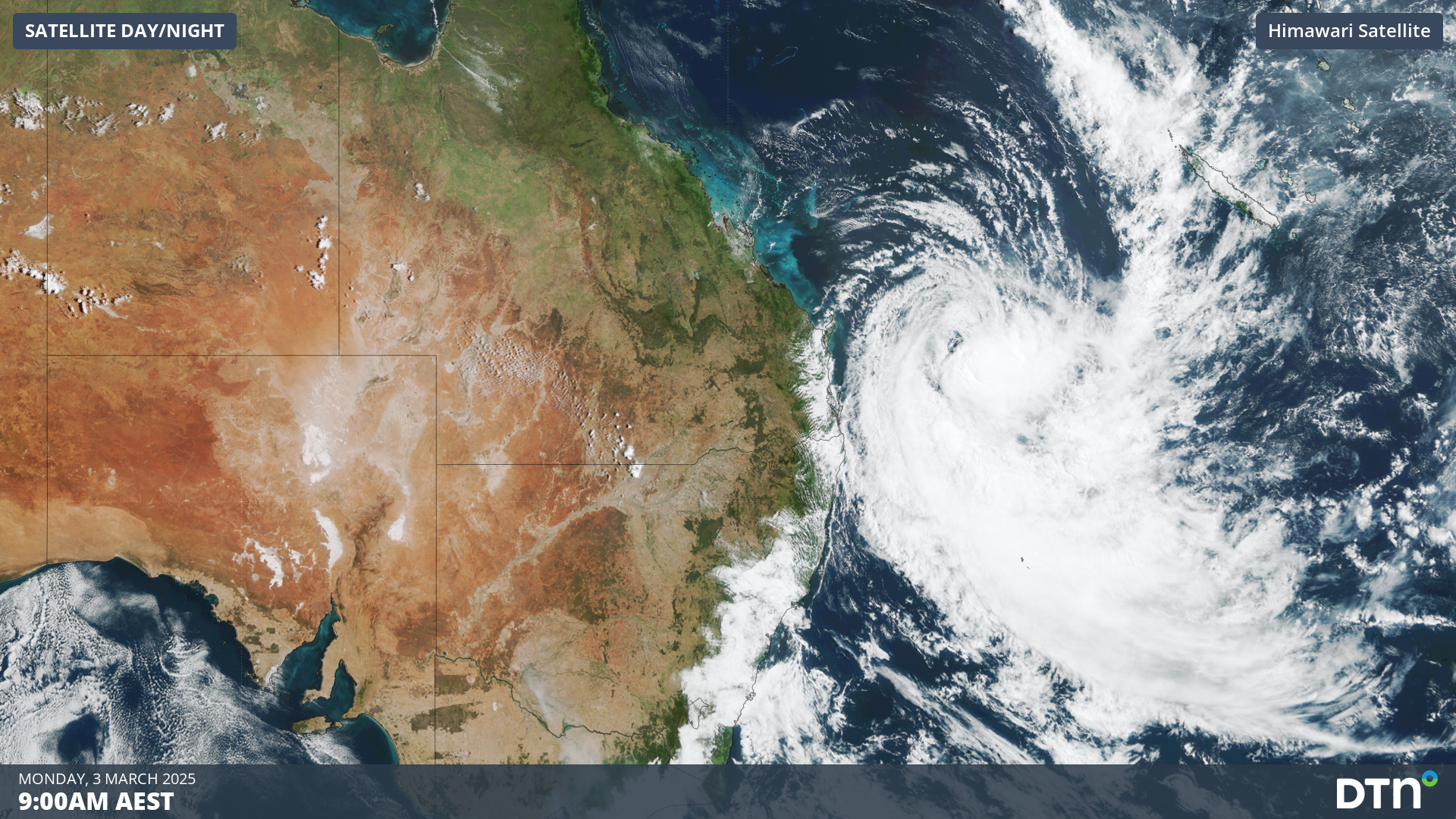
At 10am AEST on Monday, Alfred was a category one tropical cyclone located about 465km east northeast of Brisbane.
Image: Visible satellite images showing Tropical Cyclone Alfred off Australia’s east coast on Monday morning.
Alfred’s track
Alfred is currently tracking towards the southeast, allowing the system to gradually edge further away from eastern Australia. However, the influence of a high pressure ridge building over the Tasman Sea will soon cause Alfred to make a right-hand turn, most likely on Tuesday. Following this abrupt change in direction, Alfred is expected to track towards the west under the ongoing influence of the Tasman Sea ridge, which should allow it to approach the southeast coast of Qld later this week.
While forecast models have had trouble predicting Alfred’s track over the past week, there is now increasing confidence that the tropical cyclone will approach Australia’s east coast later this week. At this stage, it will most likely hit the coast in southeast Qld or far northeast NSW on Thursday or Friday.
The map below shows the Bureau of Meteorology’s forecast track map for Alfred, which was issued late on Monday morning. This forecast has Alfred crossing the Sunshine Coast as a category two tropical cyclone on Thursday night/Friday morning.
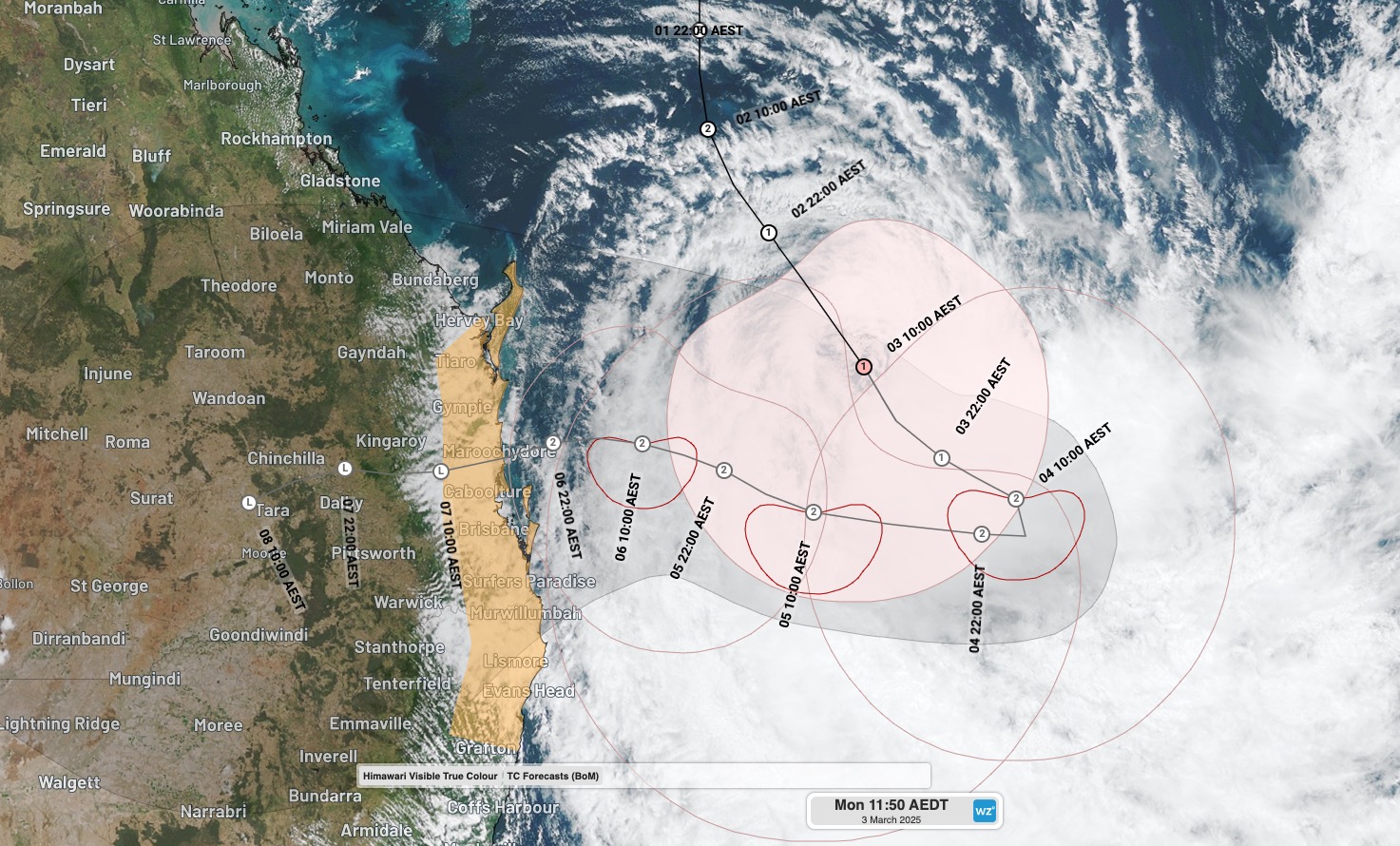
Image: Forecast track map for Tropical Cyclone Alfred, issued by the Bureau of Meteorology shortly before 11am AEST on Monday, March 3, 2025.
The Bureau’s prediction is in fairly good agreement with another track map issued by the Joint Typhoon Warming Center (JTWC), which shows Alfred crossing the coast around Caboolture on Thursday night.
Other forecast models, including the highly regarded ECMWF and GFS ensemble models, show a broader spread in possible landfall locations, extending north to around Bundaberg and south towards Evans Head. However, the most likely landfall location at this stage is southeast Qld, with landfall timing expected to be Thursday or Friday.
Alfred’s strength
Tropical Cyclone Alfred has weakened to a category one system but could restrengthen to a category two system by the time it turns towards the west on Tuesday. There is some uncertainty regarding how strong the system will be as it approaches and crosses the coast later in the week.
Alfred will be moving over progressively warmer water as it moves closers Australia’s east coast, eventually traversing a tongue of water where sea surface temperatures are around 27-28°C. This warm water should help sustain Alfred’s strength before landfall.
However, increasing vertical wind shear (a change of wind speed with height) will counteract the warm oceans and possibly cause Alfred to weaken before landfall.
At this stage, Alfred is expected to make landfall as a category one or two tropical cyclone. It’s not likely to be stronger than this (category three or higher), but it may be weaker and cross the coast below tropical cyclone strength.
Alfred’s impacts
The impacts of Tropical Cyclone Alfred will depend on its location and strength as it approaches and crosses the coast.
Based on current forecasts, heavy rain, damaging to destructive winds, very large waves and a storm surge are all likely to affect parts of southeast Qld and northeast NSW later this week, most likely between Wednesday and Friday, with flooding and rain also continuing into the weekend.
Rainfall is likely to be the biggest threat from this system, with widespread heavy rain expected across southeast Qld and northeast NSW. Some forecast models anticipate accumulated totals of more than 500 mm of rain from Alfred in parts of southeast Qld and northern NSW, particularly over elevated ranges and hinterland regions. There is potential for isolated pockets of more than 1000 mm from Alfred.
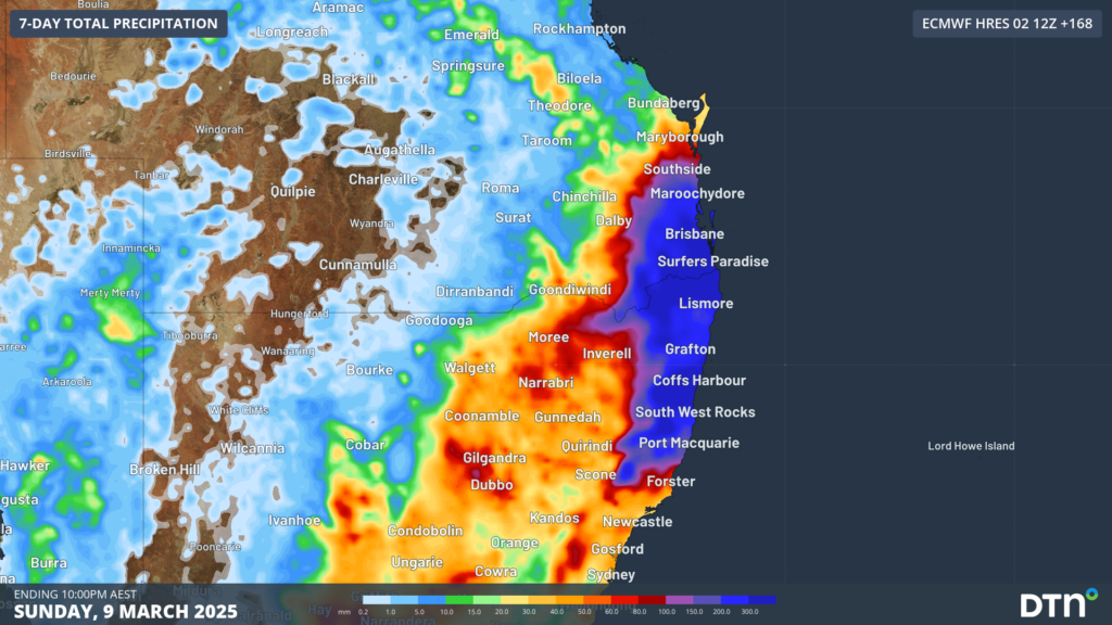
Image: Forecast accumulated rain over the seven days ending on Sunday, March 9, 2025.
Flood watches have been issued in southeast Qld and northeast NSW in response to the predicted rainfall, with major flooding likely in both states.
A tropical cyclone watch has also been issued between Sandy Cape and Grafton, where gale force winds are possible from Wednesday as Alfred gets closer to the coast.
Our team of meteorologists are watching this system closely and providing our clients with customised weather briefings, allowing businesses to be aware of the dangerous weather on its way. To find out more about large range of products and services contact us at sales.apac@dtn.com


