Aviation, mining and shipping industries in the Solomon Islands and other South Pacific nations are often unable to use traditional radar to warn of incoming storms that disrupt operations and put workers in harm’s way.
DTN APAC offers a suite of remote sensing weather solutions that give businesses and industries in remote areas around the world the confidence and safety of modern weather solutions, without costly radar installations.
For example, heavy rain and thunderstorms lashed the Solomon Islands on Wednesday. This intense weather was driven by the South Pacific Convergence Zone (SPCZ) and persisted throughout most of the day.
DTN’s Quantitative Precipitation Estimates (QPE) integrates data from radar, satellite and precipitation gauges to create comprehensive post-storm analytics. So, even outside traditional radar coverage, and with few or no rainfall gauges, DTN QPE can still estimate rainfall across remote regions. As seen below, widespread 24-hour rainfall accumulations of 20 to 30mm were recorded on Wednesday across the Solomons.
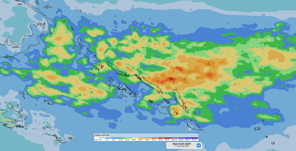
Image: DTN QPE 24-hour rainfall estimates across the Solomon Islands on Wednesday, September 17, 2025.
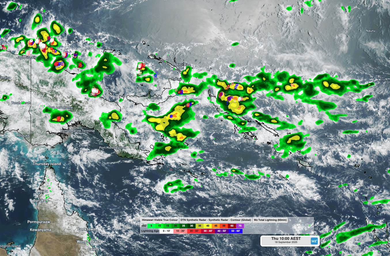
Satellite imagery covers exceptionally remote parts of the world, but it can be difficult to distinguish between non-threatening clouds, and destructive, intense thunderstorm clouds.
DTN’s Global Synthetic Radar and Oracle weather solutions derive rainfall intensity from satellite data to simulate traditional radar imagery. This tells you and your team where and when the most intense rainfall is expected, as well as giving you a real-time simulation of the direction of movement and intensity of each rain and storm cell over the next three hours. Traditional radar installations cost millions of dollars and have ongoing expensive maintenance; DTN’s synthetic radar solutions offer comparable imagery worldwide, without any expensive installations or maintenance.
Along with DTN’s simulated radar solutions, our Total Lightning Network (TLN) can detect lightning strikes with an accuracy of less than 200m, in real time, all around the globe. Over 22,750 lightning strikes were detected across the Solomon Islands on Wednesday by the DTN Total Lightning Network.
The video below compares normal satellite imagery, the only weather observations available over the Solomons, on the left, and DTN’s Synthetic Radar, TLN and satellite, on the right.
Video: Satellite imagery (left), and DTN’s Synthetic Radar and TLN (right) capturing thunderstorm and rain activity across the Solomons on Wednesday, September 17, 2025.
Using DTN’s remote sensing solutions, you don’t have to be a meteorologist reading the clouds to be able to warn and keep your workers and operations safe from hazardous thunderstorms.
How DTN APAC services the South Pacific
The South Pacific radar and weather observation network is sparse, leaving many locations and businesses in the dark when it comes to weather alerting. DTN APAC offers a powerful and accurate remote sensing array that will alert you of oncoming lightning and heavy rainfall, without needing to install costly radar technology.
The DTN Total Lightning Network
Our Total Lightning Network is the intelligent lightning solution that goes above and beyond to alert lightning and increase your lead time before the storm hits.
We utilise a vast global sensor network, created with our partner Earth Networks. Over 1,200 sensors in 40+ countries provide a worldwide view of both intra-cloud (IC) and cloud-to-ground (CG) lightning strikes, enabling businesses to plan and respond with the most precise insight available. Our system can detect and calculate strike locations with incredible accuracy, offering real-time lightning mapping for a comprehensive view of storm activity.
Offering unsurpassed accuracy, with real-time sensing to <200m, we integrate with your existing systems to keep your enterprise operating within your defined severe weather thresholds. Our technology also helps monitor radiation from electrical discharges and ensures every lightning flash is accounted for.
Leave nothing to chance. Be confident working outdoors with the most sophisticated lightning alerting system, delivering intelligence to any device across your business network. Whether you need a personal lightning alerting tool for individual safety or enterprise-wide monitoring, our solution is designed to emit timely alerts and protect your operations.
DTN’s Synthetic Radar technology
DTN’s Synthetic Radar is a satellite-derived, gridded nowcasting system. This ensures that no matter where you are on the globe, you will have access to a precision radar-like system that can rapidly inform your critical business decisions.
Working in conjunction with DTN APAC’s Stormtracker GIS system, the synthetic radar provides full situational awareness of any severe weather event that presents risk to your business. Severe weather alerts enable you to foresee the intensity and duration of events, so you can prioritise the safety and preparation of your staff and assets.
Whatever the weather, we provide the insights to help keep you and your team safe, productive and profitable.
Install your own weather station
The ObsConnect Weather Station is DTN APAC’s turn-key solution – simple to install with ongoing maintenance support provided, and easily scaled to serve your business requirements.
Our weather sensor and data hub are expertly assembled in a ready-to-deploy ruggedized cabinet so you can install the Weather Station easily, anywhere. Scheduled verification and preventative maintenance ensure reliability for your peace of mind, while DTN’s MetConsole Cloud data system facilitates seamless integration into your existing online products.
The compact, all-in-one sensor is the first of its kind to integrate all measurements into a single, intelligent package. It offers precise quantification with proven accuracy and efficiency. You will always have the situational data you need, exactly when you need it.
Reduce the time and costs associated with deploying networks of field hardware. The plug-and-play nature of its singular design ensures no specialty tools are required for installing the Weather Station on site, and your data is secure, validated and easily visualised.
Learn more about our large range of industry leading products and services or email us at sales.apac@dtn.com


