
Heavy rain, thick cloud and thunderstorms will impact several states and territories from this weekend into next week as an injection of tropical moisture moves across Australia.
A trough currently sitting over the northern interior will dip south over the weekend, dragging cloud and rain across large areas of SA, NSW, QLD and VIC from Sunday into the first half of next week.
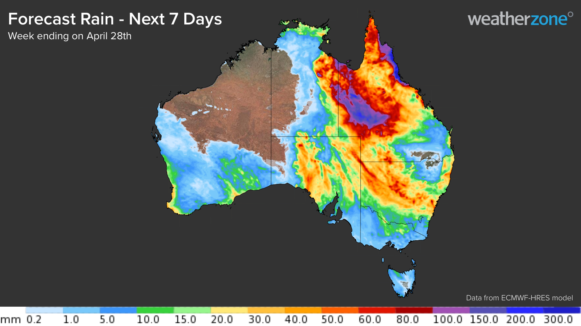
Accumulated rainfall totals of 40 to 80 mm are forecast across inland areas of these states between this weekend and the middle of next week.
However, parts of the eastern NT and western and northern QLD could see weekly accumulated rainfall totals reaching 100 to 200mm, possibly even higher in some areas. The map below shows the forecast accumulated rain from one computer model during the week ending on Thursday, April 28.

Image: ECMWF accumulated forecast rainfall for the week ending on Thursday, April 28.
The rain and cloud will initially focus on Australia’s central and northern interior on the weekend before gradually spreading further south and east early next week.
The heaviest daily falls are expected to occur over inland parts of the NT, QLD and SA on Sunday, Monday and Tuesday, with 24-hour totals of 80-100mm possible each day. Falls could exceed 100mm in severe thunderstorms, which could produce flooding.

The rain and cloud will slowly spread east early-to-mid mid next week, impacting parts of VIC, NSW and the ACT, possibly including Sydney, Canberra and Melbourne. The rain band could deliver daily rainfall totals of 40-80mm in western NSW on both Wednesday and Thursday, April 27 and 28.
The thick cloud band also has the potential to reduce solar output across the National Electricity Market (NEM) for several days. The tropical moisture associated with this system will also increase the humidity across southern and southeastern Australia next week.
Looking ahead, a cold front will approach SA late next week, which may re-establishing heavy rain, severe thunderstorms and thick cloud across southeastern Australia as it moves through.
Solar power is becoming increasingly important in the Australian energy markets; however, the variable nature of solar generation poses significant challenges for integration into the electricity industry.
Weatherzone, in partnership with Solcast, provides solar power forecasting and solar irradiance data, for both large-scale solar farms and small-scale PV systems, plus their grid or regional aggregates. For more information, please contact us at apac.sales@dtn.com.




