Prosper in a dynamic world
Search

Sydney to soar to 40 on last day of summer

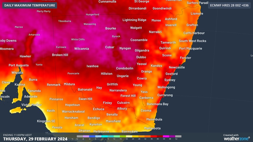
Sydney is set to soar to 40 on the last day of summer, with parts of the city’s west likely to reach 39°C or 40°C, while the city should reach 35°C before a late cool change arrives.

On Wednesday, temperatures topped 43°C in several spots in the Mallee region in Victoria’s northwest, while temps reached 44°C in at least two locations in far western New South Wales.

That heat has been tracking across southern Australia from west to east for several days, and it will finally reach the east coast on Thursday, with only Sydney’s coastal suburbs spared the worst of the heat.

Canberra is also in for a reasonably hot one with a top of 34°C expected, which will make Thursday one of the sweatiest days of the 2023/24 summer.

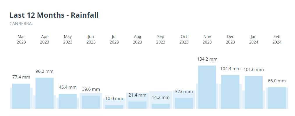
The national capital hasn’t had a particularly warm summer by its standards, with a hottest day to date of 34.8°C on December 9. Rain tends to keep a lid on extreme daytime temperatures, and as you can see on the graph below, Canberra has indeed had a wet summer.

As of Wednesday evening, the bushfire danger for Thursday is currently rated as high in about half of New South Wales, but it will pay to keep checking the latest info at the Rural Fire Service website.

Your business can benefit from the timely delivery of accurate weather information, allowing informed and effective decision-making. For more information, please contact us at apac.sales@dtn.com.

Latest news

Satisfy your weather obsession with these news headlines from around the nation, and the world.

From Kimberley to northern NSW: Bushfire outlook flags risk for resources sector this winter

Bushfire risk doesn’t usually make headlines in June, but AFAC’s winter seasonal outlook is putting mining and resources operators on alert from the Kimberley to the NSW.  Australia’s official seasonal bushfire outlook for winter 2026 was released by AFAC on Thursday, May 28. The outlook predicts increased fire risk across the northern parts of the Great Sandy Desert and surrounds […]

The signal was there weeks earlier: forecasting one of the year’s biggest wind events

In mid-May 2026, DTN APAC meteorologists flagged a strengthening Southern Ocean pattern in model guidance, signalling an extended run of record-challenging wind conditions across the NEM.  Nearly three weeks later, NEM wind generation climbed from around 1.5GW to more than 9GW, supplying roughly one-third of the grid and coming within 1GW of the all-time generation record.  The event highlighted […]

The 2026 Indian Southwest Monsoon onset is expected in the next two weeks

The Indian Southwest Monsoon will reach India in the next two weeks, but a developing El Niño could signal a drier than normal monsoon for businesses and major industries across the country. Southwest monsoon onset over southern India in the next two weeks The Indian Meteorological Department (IMD) is responsible for tracking the advance and […]

Rapid El Niño signal accelerating risk for Australian businesses

El Niño–favourable conditions are gathering pace across the tropical Pacific, with key ocean indicators approaching threshold levels and early atmospheric responses emerging.  While uncertainty remains around final El Niño strength, historical analogues show that even weak events can generate widespread impacts, including reduced rainfall, warmer daytime temperatures, increased frost risk, elevated fire danger, reduced tropical cyclone activity, and more. Industries including […]