
NSW is sweating through uncomfortably hot and humid conditions on Thursday, before the sultry weather shifts its focus to Qld on the weekend.
A low-pressure trough will drag a warm and muggy airmass over eastern Australia during the next few days.
The map below shows the hot temperatures forecast on Thursday, December 14.
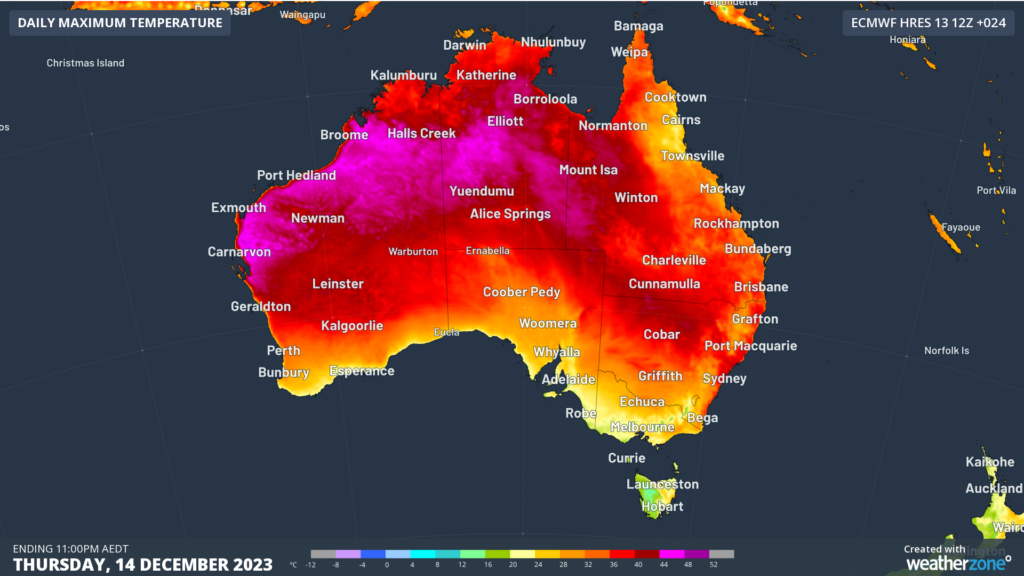
Image: Maximum temperature forecast for Thursday, December 14, according to the ECMWF model
Sydney Observatory Hill is expecting a top of 37°C on Thursday, while the city’s western suburbs could see temperatures reach near 40°C. The heat across NSW is also bringing extreme fire danger to the Greater Sydney and Hunter regions on Thursday, before the elevated fire danger shifts to northeastern NSW and Qld from Friday.
One of the most notable features about the weather in Sydney on Thursday is the very high dewpoints coinciding with this heat.
The dewpoint is the temperature at which air must be cooled to achieve a relative humidity of 100% or saturation of the atmosphere. The higher the dewpoint, the greater the amount of moisture in the atmosphere, which makes it more difficult to cool down through the evaporation of sweat.
For example, this is how different dew point temperatures would make you feel if you were accustomed to Australia’s sub-tropical climate:
- >24°C – Oppressive, uncomfortable for most, possible heat stress issues
- 20-24°C – Muggy and quite uncomfortable
- 15-20°C – Starting to feel muggy, though still comfortable for most
- 10-15°C – Comfortable 5-10ºC – Dry
- < 5° C – Very dry
As of 11:30am on Thursday, the dewpoint temperature was a remarkable 22.7°C at Sydney Observatory Hill. This dew point is more common in the tropics than Sydney and it is making Sydney feel around 5°C warmer than the actual air temperature.
The map below shows the uncomfortably high dewpoints (blue and purple) forecast across NSW and Qld on Thursday afternoon.
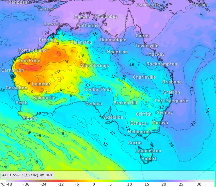
Image: Dewpoint temperature (°C) at 5pm AEDT on Thursday, December 14, according to the ACCESS-G model.
The heat and humidity will subside for Sydney later Thursday, as a southerly change arrives between 8-10pm and drags cooler and drier air into the city.
While conditions will cool in parts of NSW, extreme fire danger and heat will continue to impact northeastern NSW and southeastern Qld between Friday and Monday.
Brisbane is expecting three consecutive days of temperatures in the mid 30’s. These temperatures will feel 3-5°C hotter with uncomfortably high humidity impacting the region for several days.
Looking ahead, the heat and humidity will ease slightly from early next week for Brisbane, while Sydney is expecting another round of heat next Tuesday.
You can’t control the weather, but you can gain precision insights to optimise your response. What lights us up is providing your energy business with tailored weather information to reduce your risk and keep you moving ahead of the curve.
Our services cover all aspects – from wind and solar generation to demand forecasts, wholesale markets to retail so, no matter where your company sits, we have solutions for you. We have worked closely with market participants to create products that meet the evolving needs of the sector, aiming to increase safety and profitability for our customers.
Benefit from the timely delivery of accurate weather information, allowing informed and effective decision-making. For more information please contact us at apac.sales@dtn.com.


