Prosper in a dynamic world
Search

Summery warmth returns to the NEM

Temperatures above 35 degrees are returning to the National Electricity Market as the lead-up to summer begins.
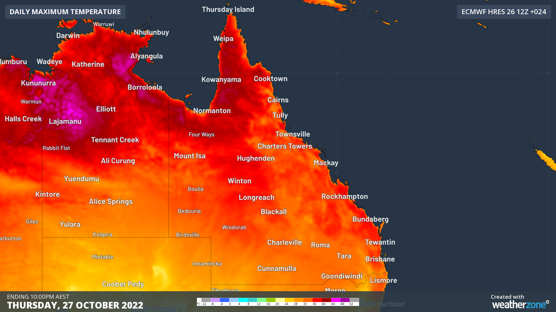
Weatherzones forecast model Opticast predicts temperatures to reach 36°C at Rockhampton, 35°C at Gympie, and 34°C at Bundaberg, Cairns and Townsville. In the state’s capital, 35°C is expected for Ipswich, 34°C at Archerfield and 33°C for Brisbane City.

All of these temperatures will be the hottest days for each location since March or April.

20221027-nwp-tmpmax-ecmwf-hres-024_au-qld_1920x1080

Image: Maximum temperatures forecast for Thursday 27th Oct from ECMWF

Those locations close enough to the ocean will receive a seabreeze today, helping to cool temperatures down later in the afternoon. The caveat to this is that a seabreeze also raises the humidity. This means some places like Ipswich and Rockhampton can receive a weak seabreeze, but the increase in humidity makes it feel even hotter than before it arrived.

The humidity today will make the length of the east coast feel 2 to 3 degrees above actual temperatures. This is fairly standard for Queensland heat but would certainly be sweaty conditions for any southerners visiting.

This heat has originated from WA’s Kimberleand the NT’s Top End, where temperatures above 40°C have been recorded since mid-September. This region is sometimes called the ‘heat generator’ for Australia, as hot air that spreads across the continent often originates there.

While a trough moving through on Thursday afternoon will provide some cooling, heat will return to Queensland early next week, when humidity will be even higher.

DTN APAC can provide access to our state-of-the-art Opticast models, including temperature bounds, to provide accurate temperature forecasts as far as 14 days in advance. We also provide climate briefing services, so you know what to expect for this upcoming summer. To find out more please contact us at apac.sales@dtn.com.

Latest news

Satisfy your weather obsession with these news headlines from around the nation, and the world.

El Niño Is Here: What a Potential Record Event Means for Southeast Asia and Australia

  El Niño was officially declared in June 2026, raising the prospect of widespread impacts across Southeast Asia, from extreme heat and water shortages to higher energy demand and agricultural stress.   The World Meteorological Organization has warned countries to “prepare for it to be severe”, while several global forecast models suggest the event could rank among […]

How El Niño will shape Australian port operations in winter-spring 2026

Australian ports and marine pilots can expect a season of shifting wind and swell patterns through winter and spring 2026, as a developing El Niño brings the likelihood of drier conditions and more variable operating windows across the country’s coastline.  Will El Niño develop in 2026?  There are clear signs that an El Niño pattern is becoming […]

From Kimberley to northern NSW: Bushfire outlook flags risk for resources sector this winter

Bushfire risk doesn’t usually make headlines in June, but AFAC’s winter seasonal outlook is putting mining and resources operators on alert from the Kimberley to the NSW.  Australia’s official seasonal bushfire outlook for winter 2026 was released by AFAC on Thursday, May 28. The outlook predicts increased fire risk across the northern parts of the Great Sandy Desert and surrounds […]

The signal was there weeks earlier: forecasting one of the year’s biggest wind events

In mid-May 2026, DTN APAC meteorologists flagged a strengthening Southern Ocean pattern in model guidance, signalling an extended run of record-challenging wind conditions across the NEM.  Nearly three weeks later, NEM wind generation climbed from around 1.5GW to more than 9GW, supplying roughly one-third of the grid and coming within 1GW of the all-time generation record.  The event highlighted […]