
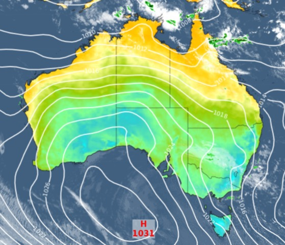
It’s a chilly and showery end to the working week across southeastern Australia, after a strong surge of south to southeasterly winds pushed cool air across the region overnight.
- Melburnians awoke to some welcome rain with 6 mm in the gauge in the 24 hours to 9 am, most of it falling around dawn.
- After our story yesterday about the desperately dry start to 2024 in Tasmania, Hobart also saw a drop or two overnight with 1 mm in the city and 6.6 mm up on kunanyi/Mt Wellington where it was almost but not quite cold enough for snow, dropping to a minimum of 1.4°C.
Those sorts of moderate rainfall totals obviously won’t alleviate the severe rain deficiency for the year to date, but it was better than nothing.
The map below shows rainfall across Australia to 9 am Friday, with showers right across Tasmania and most of Victoria, coastal and northern NSW, and parts of Queensland.

Source: BoM.
The synoptic chart below shows a cold front east of Tasmania that stayed south of the mainland, but as mentioned, there’s enough cool air circulating around that high centred over the Great Australian Bight to give the southeast of the country a distinctly autumnal feel.

Meanwhile as we write this story around 10 am on Friday morning, Sydney is mild and sunny and approaching 20°C under the influence of westerly winds but by lunchtime, a southerly change will blow into town making things feel a lot cooler.
Sydneysiders got a bit of a surprise on Thursday with the severity of thunderstorms that whipped through the city in the early afternoon. The potential for storms was always on the cards yesterday, but the speed with which they developed and the hail in some suburbs caught many residents off guard.
#Sydney being hammered by rogue hail storm… pic.twitter.com/tiUH6zsA4v
— Chris Mitchell (@chrismbbcsport) April 18, 2024
Some showers will accompany the southerly to Sydney this Friday afternoon and stick around for 24 hours or so before clearing by Sunday. In Melbourne, the clearing pattern has already begun and a cool but mostly fine weekend looms ahead.




