
Heat is set to return to parts of southern Australia on the weekend, as another hot airmass sweeps across the region.
Strengthening northerly winds will drag warm air across parts of SA, TAS, VIC, NSW, the ACT and QLD this weekend, ahead of a deepening low-pressure trough and cold front.
The impending hot air will cause a low intensity heat wave across southern Australia from the weekend, which will spread further east and northwards early next week.
Melbourne’s heat is likely to peak on Sunday, with a maximum temperature of 34ºC on the forecast, as hot northerly winds strengthen ahead of the approaching cold front. However, it may reach around 35-37ºC in the city on Sunday if northerly winds prevent a cooling sea breeze from developing.
Unfortunately, the mercury will remain in the 30’s well into Sunday evening in Melbourne, before a weak southerly change later in the evening provides some relief. But this weak southerly will only be temporary, with temperatures forecast to reach the low 30’s on Monday.
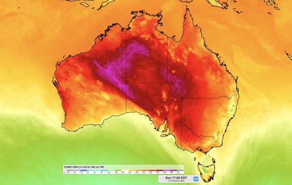
The map below shows the warm airmass moving over southern Australia on Sunday, February 13.

Image: ECMWF 2M temperature at 5pm EDT on Sunday, February 13.
Across the border, Adelaide’s daytime temperatures will peak in the low to mid 30’s on Sunday and Monday. Saturday night is expected to be a particularly warm night, with the temperature likely to stay above 22ºC, which is five degrees above the February average.
A weak southerly will arrive in Adelaide on Sunday afternoon, preventing extreme heat, but not enough to cool the capital significantly. A stronger southerly is set to arrive on Tuesday in both Adelaide and Melbourne, finally dropping temperatures below 30ºC
Hobart will not miss this late summer warmth, with temperatures peaking at 30ºC on Sunday, 8 degrees above the average maximum for this time of year. The cold front will clip TAS on Monday dropping temperatures to the low 20’s.
Looking ahead, the warm airmass will spread over the eastern states next week, with several days of high 20’s to low 30’s on the forecast for both Sydney and Brisbane.
Weatherzone’s model Opticast is an industry leading high-precision forecast system, optimised for both “realtime nowcasting” as well as up to 15 days. Developed by Weatherzone over 10 years ago, it quickly rose to become one of the most trustworthy forecasts available in the Australian market and has been independently verified to outperform other similar systems.
Opticast is continuously optimised in real time, and significantly outperforms single-model forecasts of temperature, humidity, wind speed and direction, cloud cover and rainfall (amongst over 30+ parameters). The forecasts update hourly based on real time observations, and the latest guidance from a suite of Numerical Weather Prediction models. For more information, please contact us at apac.sales@dtn.com.




