Perth has never seen a run of May days this warm since records started being kept in 1876.
- Since May 7, Perth’s maximum has reached between 24.9°C and 29.4°C every day.
- The previous record run of May days with a top of 24°C or higher was in 2018, with 16 consecutive days.
- As of 9 am Thursday, Perth has just equalled the streak of 16 straight days above 24°C, and as mentioned, each of those days has reached at least 24.9°C. So the city is in record-setting territory for late autumn warmth.
- For perspective, Perth’s average May maximum from 1993 to 2023 was 22.3°C at the city’s official Perth Metro site.
- Prior to 1993, the average May maximum at the old Perth regional Office site from 1876 to 1992 was 20.9°C. The two sites are 4 km apart and at a similar elevation.
And the streak is not over yet.
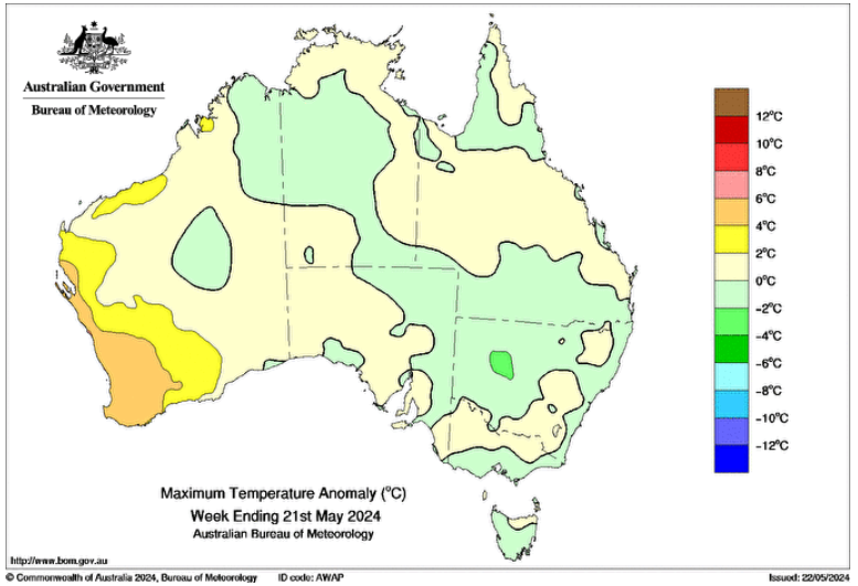
Image: This chart showing max temp anomalies Australia-wide in the week to May 21 is a snapshot of just how warm it has been in southwest WA. Source: BoM.
Perth’s warm weather looks set to continue with winter barely a week away, with Thursday’s top tipped to reach 27°C, followed by highs of 26°C, 24°C and 25°C through to Sunday before things cool down slightly in the new week.
OUR PERTH WEATHER FORECAST IS HERE
As ever, even the quickest glance at our synoptic chart reveals the reason for the persistent late May warmth.
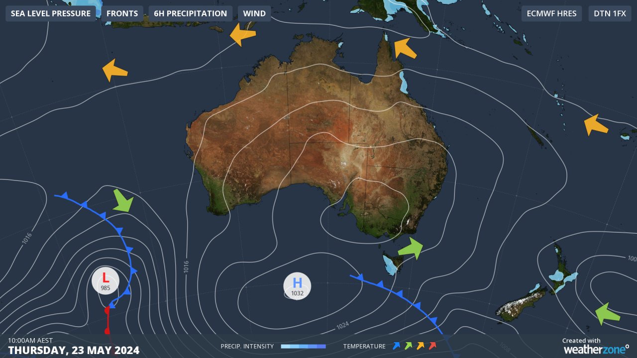
Stubborn, slow-moving high pressure systems centred over the Great Australian Bight have been pushing warm air from the interior of Western Australia towards the southwest of the state (air circulates anti-clockwise around a high).
Those same highs have been winning the atmospheric arm wrestle with the cold fronts, forcing most of them south of the mainland. Like most cold fronts to appear on charts in recent weeks, the one situated southwest of the continent in the chart above will also slide south and only graze the SW corner of the state.
The front should pack enough of a punch to generate at least a few showers in coming days in Perth itself and across the Lower West, South West and South Coastal forecast districts, although temperatures will remain warm until an injection of slightly cooler air underly southerly winds in the new week.
Even chilly old Albany – the southernmost town in Western Australia – is expected to see maximums of 23°C, 25°C, 23°C and 24°C from today through to Sunday.
These mild maximums are expected even with the likelihood of showers. Given that cloudy weather tends to reduce the amount of direct sunlight for warming, it shows just how warm the airmass over the southwest corner of WA is for this time of year.
Albany’s average maximum in May 2024 to date has been 22.7°C. That’s 3.2 degrees warmer than usual.
Weatherzone Business has grown to become the outright leader within the Australian energy market, serving wind, solar, hydro, trading, utilities and network companies.
You can’t control the weather, but you can gain precision insights to optimise your response. What lights us up is providing your energy business with tailored weather information to reduce your risk and keep you moving ahead of the curve.
Our services cover all aspects – from wind and solar generation to demand forecasts, wholesale markets to retail so, no matter where your company sits, we have solutions for you. We have worked closely with market participants to create products that meet the evolving needs of the sector, aiming to increase safety and profitability for our customers.
Benefit from the timely delivery of accurate weather information, allowing informed and effective decision-making. For more information, please contact us at apac.sales@dtn.com.


