The recent spring-like weather in Australia’s southeastern states is set to end abruptly, as a band of fierce winds, rain and severe thunderstorms spread across the region in the coming days.
The satellite image below shows a low pressure system and associated front to the south of WA approaching SA rapidly from the west on Wednesday morning.
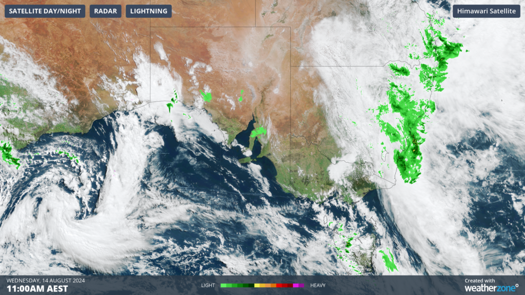
Image: Himawari-9 satellite image at 11am AEST on Wednesday, August 14
You can see in the image above that much of SA is experiencing a sunny day ahead of this low pressure system.
The southern states have experienced warm and mild weather since Sunday, with Adelaide set to see a run of five days over 20°C between Sunday and Thursday.
This beautiful run of weather will end abruptly Thursday night with the passage of the front, with temperatures dropping to the mid teens on Friday in Adelaide and Saturday in Melbourne.
The low will also bring the potential for rain and thunderstorms, which will begin in SA from Thursday afternoon and spread towards the southeast into Vic, NSW and the ACT on Friday and Saturday.
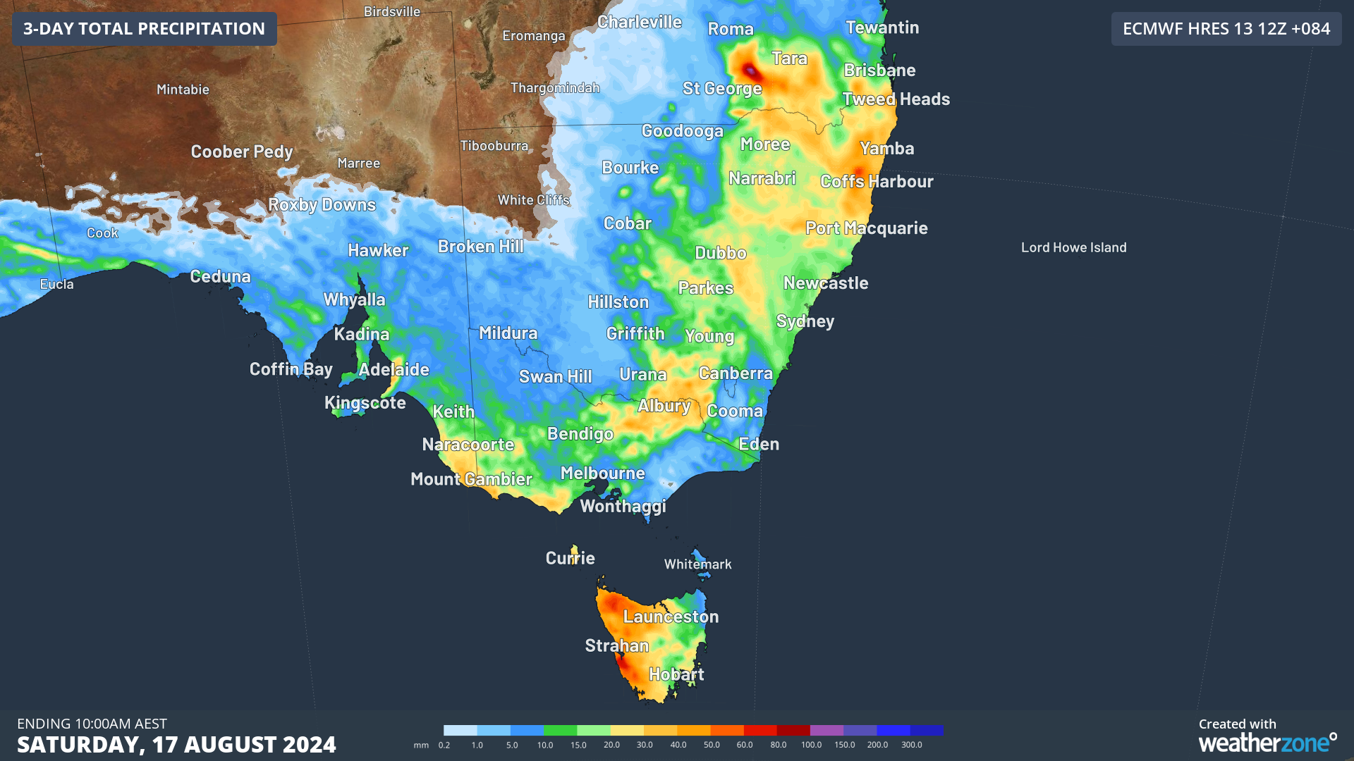
The image below shows that widespread falls of 20 to 40 mm are forecast in the next three days across southeastern SA, parts of Vic and NSW, while western Tas could see 40 to 60 mm.
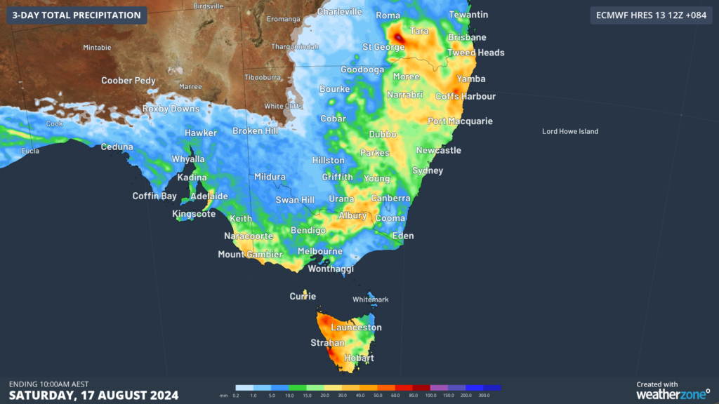
Image: Accumulated rain forecast for the next 3 days leading up to 10am Saturday, August 17.
Severe thunderstorms are possible in SA from Thursday afternoon and NSW, the ACT and Vic on Friday. The most likely phenomenon is damaging winds in these storms and small hail. In NSW on Friday there is potential for a squall line to form which could generate damaging winds across parts of the state.
This system will also elevate wind power in the southeast between Thursday and Saturday.
Looking ahead, the wind, storms and rain should clear later on the weekend, before another strong cold front approaches Australia’s southeast mid next week.
Are increasingly volatile weather events affecting your insurance company’s bottom line?
Given weather affects your business at all levels of operation, from risk assessment to sales and claim management, it’s worth gaining the foresight of our industry-leading, comprehensive weather services.
DTN APAC, a DTN company, offers you trusted weather intelligence, alerting and analytics to support your business, bringing ease to your risk and claims management.
Severe weather and conditions alerting
Weatherzone’s alerting allows your organisation to mitigate severe weather insurance claims and protect policy holders from lightning, hail, bushfires and other natural disasters. Address specific SMS alerts are sent up to 30 minutes prior to a severe storm’s impact, giving your customers time to prepare themselves, protecting both assets and life. Our alerting system combines the proven technology of TITAN Tracks, with our own Dangerous Thunderstorm Alerts (DTAs) and Total Lightning Network, so you are protected by the most precise service available.
Historical severe weather reporting
StormQuery creates storm reports based on historical data from the Bureau of Meteorology and lightning strike information from our own Total Lightning Network. You can draw historical lightning and severe weather reports – geo-tagged to any address and postcode – to quickly and accurately verify severe weather insurance claims. StormQuery is seamlessly embedded within the Weatherzone interface and is easy to visualise and utilise.
Long-range forecasts
Long-range forecasts enable you to prepare for the seasons ahead – whether it’s tropical cyclone risk, La Niña’s above average rainfall or the bushfire seasons of El Niño. With that foresight, you can equip your customers with the strategies they need to mitigate loss due to fire, flood and severe weather. Nurture your relationship with your customers by providing them with the tools to protect themselves and their assets from increasingly volatile conditions. Data from the forecast reports can also be incorporated into your reinsurance negotiations.
Rain, hail or shine: we are there for you, and your customers. To find out more visit our contact page or email us at apac.sales@dtn.com.


