Prosper in a dynamic world
Search

Queensland’s 2nd-hottest recorded temperature


With Cyclone Kirrily set to make landfall around 11 pm just north of Townsville, and with a heatwave in the diagonally opposite corner of the state, there’s no shortage of dangerous weather in and around Queensland this Thursday.

  • Temperatures were forecast to reach 49°C out at Birdsville in the southwest corner of the state, and the mercury got there with a bit of extra mayo, with a reading of 49.4°C just after 2:30 pm.
  • That made it the 2nd-highest Queensland temperature ever recorded, just shy of the 49.5°C scorcher on Christmas Eve, 1972, which also occurred in Birdsville.

Birdsville is a tiny map speck of 100 hardy residents, best known for its famous bush races in later winter or early spring, an event which swells the town’s population to 6000.

Here at Weatherzone, we actually wrote a story about the first day of the Birdsville races being called off in 2022 due to heavy rain.

There were plenty of images of mud-spattered locals and visitors that day, but today, the town was its typical dusty self.

Image source: iStock.

Meanwhile temperatures should cool down a little in Birdsville on Friday with a top of 46°C predicted and a further cooling trend into the weekend with top temps closer to average for January – which means around 40 degrees.

But the heat will push eastwards with large parts of southern, central and eastern Queensland, as well as northern and eastern parts of NSW, in line for a heatwave.

Brisbane will be pretty much in the bullseye of the heatwave, as you can see on the map below.
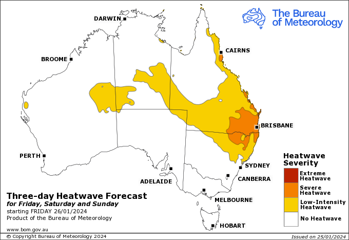
Source: BoM.

Latest news

Satisfy your weather obsession with these news headlines from around the nation, and the world.

Rapid El Niño signal accelerating risk for Australian businesses

El Niño–favourable conditions are gathering pace across the tropical Pacific, with key ocean indicators approaching threshold levels and early atmospheric responses emerging.  While uncertainty remains around final El Niño strength, historical analogues show that even weak events can generate widespread impacts, including reduced rainfall, warmer daytime temperatures, increased frost risk, elevated fire danger, reduced tropical cyclone activity, and more. Industries including […]

Australia’s 2025–26 Cyclone Season: Slightly Above Average, Dominated by Severe Systems

Australia has just experienced a highly impactful tropical cyclone season, with more than 60% of systems reaching severe intensity, causing widespread disruption and damage to communities and multiple industries across northern Australia.  The 2025–26 Australian tropical cyclone season officially ran from 1 November 2025 to 30 April 2026. During this six-month period, Australia saw 11 tropical cyclones, with nine […]

What does a ‘super El Niño’ mean for Australia’s businesses?

There are signs that a very strong, or ‘super’ El Niño could develop in the tropical Pacific Ocean later this year. So, what does this mean for Australia’s weather during the second half of 2026? El Niño on the horizon The tropical Pacific Ocean is currently in a neutral state, meaning neither El Niño nor […]

How does DTN help businesses monitor bushfire induced pyrocumulonimbus thunderstorms that ignite more fires?

Intense heat from bushfires during elevated fire danger days can trigger fire-induced pyrocumulonimbus thunderstorms that ignite additional fires. In early January 2026, an extreme heatwave sweeping over southeastern Australia brought catastrophic fire danger to Victoria. Intensely hot bush and grass fires spread erratically and quickly in hot, dry and gusty winds, with pyrocumulonimbus generating lightning, […]