A sweltering air mass will spread over eastern Australia during the next few days, causing another burst of stifling heat in Sydney and possibly challenging Queensland’s maximum temperature record.
Earlier this week, a very hot air mass delivered the hottest morning on record for Qld and the hottest day Adelaide has seen in three years. Now, this heat is spreading towards further east, driving the stifling heat across large areas of NSW, Qld and the ACT.
Over the next three days, a severe heatwave will impact parts of Qld and NSW, while extreme heat wave conditions will affect parts of the Mid North Coast and Hunter in NSW, and the Channel Country in Qld.

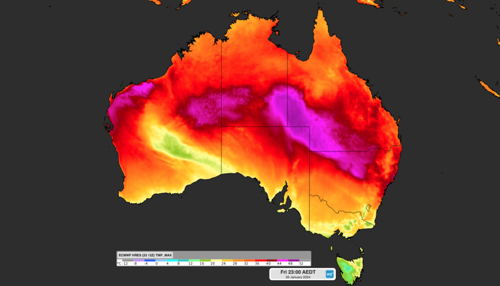
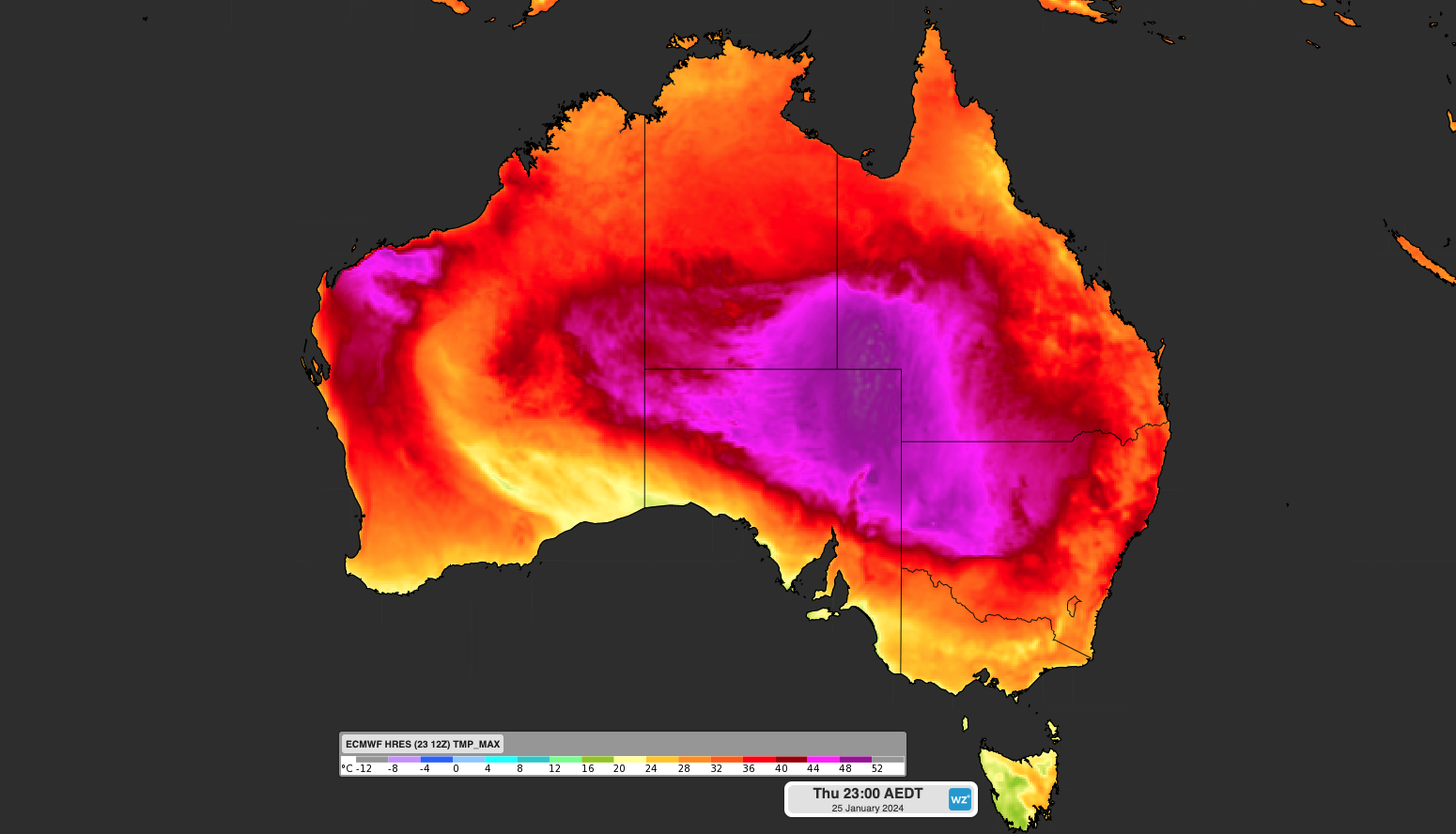
Image: Maximum temperature forecast for Thursday (top) and Friday (bottom), according to the ECMWF model
The maximum temperatures in these regions should reach the low to mid 40’s in some areas, while in southwest Qld, temperatures could approach 50°C.
Qld could challenge its all-time temperature record on Thursday, which was set at Birdsville Police station when the mercury reached 49.5°C in 1972.
Birdsville’s maximum temperature forecast on Thursday is 49°C. If it gets more than half a degree warmer than this, it will set a new maximum temperature record for Qld.
Meanwhile in Sydney, the temperature is forecast to the mid 30’s at Sydney Observatory Hill on Thursday and Friday, with the west sweltering through temperatures in the high 30’s and possibly into the 40s on both days.
Unfortunately, this heat will be combined with a humid air mass, which could make the temperature feel 5-10°C hotter than the actual temperature, particularly on Thursday.
The high humidity on Thursday could be similar to Sydney’s muggiest day on record, set only a fortnight ago when hourly dew points reached as high as 25.9°C.
#BREAKING – #Sydney has today registered its highest dew point on record, based on hourly observations, after reaching 25.9ºC at 11am. Sub-hourly dew points have gone as high as 26.7ºC so far, although these can’t be compared to historical data. Phenomenal obs for Sydney. https://t.co/jqVunTG8mL
— Ben Domensino (@Ben_Domensino) January 11, 2024
The map below shows that the dewpoint could reach 26.8°C on Thursday afternoon, which could make the ‘feels like’ temperature around 40°C.
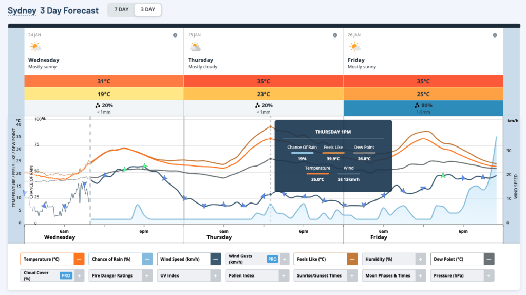
Image: Sydney 3-day temperature (bright orange), feels like (burnt orange) and dewpoint (grey) forecast.
However, there is a chance that a weak southerly wind could arrive around midday on Thursday, which could cool temperatures briefly for a few hours around the middle of the day, as well as strengthening the southerly winds. This weak change could impact Thursdays daytime and overnight temperatures.
The overnight temperature on Thursday night will also be warm and humid, with the temperature expected to remain above 25°C.
There are signs that northwesterly winds could strengthen overnight Thursday, keeping the city 1-2°C. warmer than forecast overnight. This could challenge Sydney’s January minimum temperature record of 26.2°C or even the all-time minimum record of 27.6°C.
The warm overnight minimum means that Friday morning will already start off very warm, with the maximum temperature potentially occurring in the late morning or early afternoon.
Fortunately, there will be some relief on Friday, with a southerly change expected to drop the temperature by 10-15°C in a few hours when it arrives between 12-2pm AEDT.
However, if this change arrives late, the temperature could reach 40°C on Friday, delaying the relief for the city.
While Sydney will be much cooler on the weekend, the heat will maintain its focus on Brisbane, with temperatures forecast to reach the mid 30’s.
This heat will also combine with high humidity, making it feel 5-10°C hotter than the actual temperature in Brisbane over the weekend. For more information on our temperature, extreme temperature and energy forecasts please contact us at apac.sales@dtn.com.


