Prosper in a dynamic world
Search

Northwest cloud band to reduce solar output later this week


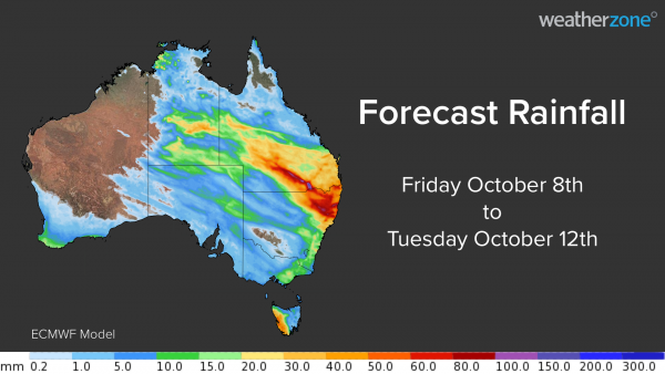
Australia’s wet October will continue over the next four days as a northwest cloud band delivers widespread rain and thunderstorms in parts of six states and territories. The map below shows how much rain one computer model is predicting between today (Friday) and Tuesday next week.  

 MicrosoftTeams-image (70)

Rainfall totals of 5-15mm are likely over a broad area in central and eastern Australia, covering parts of the NT, SA, QLD, NSW, the ACT, VIC and TAS.  Some areas in southern QLD and northern NSW could see more than 50mm during this event, with isolated pockets above 100mm possible, most likely with thunderstorms. 

 Showers and thunderstorms will start to develop over SA, VIC and TAS on Saturday as a cold front reaches southern Australia. Rainfall will mostly be light in the absence of thunderstorms. Rain will become more widespread over central and southeastern Australia on Sunday as a northwest cloud band starts to develop across the country. Several states will see rain on Sunday and thunderstorm activity will start to ramp up in central Australia. 

MicrosoftTeams-image (69)

 On Monday, the cloud band will move further north and east and tap into increasing levels of moisture-laden air from the Coral Sea. This will result in widespread rain from the NT, across central and southern QLd, into northern and eastern NSW.  Rain will be the main feature of this northwest cloud band on Monday, although some areas of the NT, southern QlLD and northern NSW could see thunderstorms. 

 On Tuesday, the rain will focus on southeast QLD and northeast NSW as the cloud band contracts towards the eastern seaboard. Models suggest that some areas will see heavy rain, with potential for more than 50mm on Tuesday alone. 

 The northwest cloud band is likely to reduce solar output across many states and territories from Sunday. Parts of NSW and QLD are likely to see thick cloud cover for two to three days, reducing solar output for longer periods in these areas.  For more information on Weatherzone’s solar, rain thunderstorm forecasting services, please contact us at apac.sales@dtn.com 

Latest news

Satisfy your weather obsession with these news headlines from around the nation, and the world.

El Niño Is Here: What a Potential Record Event Means for Southeast Asia and Australia

  El Niño was officially declared in June 2026, raising the prospect of widespread impacts across Southeast Asia, from extreme heat and water shortages to higher energy demand and agricultural stress.   The World Meteorological Organization has warned countries to “prepare for it to be severe”, while several global forecast models suggest the event could rank among […]

How El Niño will shape Australian port operations in winter-spring 2026

Australian ports and marine pilots can expect a season of shifting wind and swell patterns through winter and spring 2026, as a developing El Niño brings the likelihood of drier conditions and more variable operating windows across the country’s coastline.  Will El Niño develop in 2026?  There are clear signs that an El Niño pattern is becoming […]

From Kimberley to northern NSW: Bushfire outlook flags risk for resources sector this winter

Bushfire risk doesn’t usually make headlines in June, but AFAC’s winter seasonal outlook is putting mining and resources operators on alert from the Kimberley to the NSW.  Australia’s official seasonal bushfire outlook for winter 2026 was released by AFAC on Thursday, May 28. The outlook predicts increased fire risk across the northern parts of the Great Sandy Desert and surrounds […]

The signal was there weeks earlier: forecasting one of the year’s biggest wind events

In mid-May 2026, DTN APAC meteorologists flagged a strengthening Southern Ocean pattern in model guidance, signalling an extended run of record-challenging wind conditions across the NEM.  Nearly three weeks later, NEM wind generation climbed from around 1.5GW to more than 9GW, supplying roughly one-third of the grid and coming within 1GW of the all-time generation record.  The event highlighted […]