
The Southern Annular Mode (SAM) has strongly negative for the first time in 2024, bringing the first cool spell and snowfall to parts of southeastern Australia this week.
The image below shows a strong cold front sweeping across the region on Wednesday.
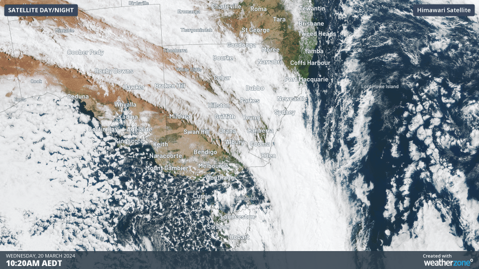
Image: Himawari-9 satellite image for the three hours leading 1:20pm AEDT on Wednesday, March 20.
This cold front has dragged a frigid airmass originating from Antarctica into the southeast, after a warm day on Tuesday. Melbourne’s temperature was 14°C at 1pm on Wednesday, which is 14°C degrees cooler than the same time on Tuesday.
The SAM is climate driver that influences wind, rain and snow in Australia. So, what does negative SAM mean for our weather as we head through the middle of Autumn?
What is the SAM?
The SAM is simply an index that’s used to monitor the position of a belt of westerly winds that flow from west to east between Australia and Antarctica.
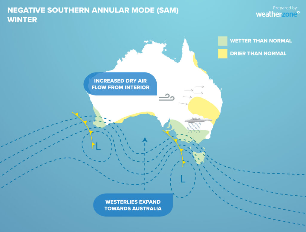
When the SAM is in a negative phase, these westerly winds, and the cold fronts and low pressure systems they carry, are located further north than usual for that time of year.
Negative phases of the SAM during late-autumn and winter often:
- Increase rainfall over southwestern and southeastern Australia
- Reduce rain in parts of eastern Australia
- Cause stronger westerly winds in southern Australia
When the SAM is positive, the westerly winds, cold fronts and low pressure systems are located further south than usual.
By contrast, positive phases of the SAM in late autumn and winter can:
- Suppress rainfall in Australia’s southwest and southeast
- Reduced frequency of strong winds
- Increase rain over eastern Australia
- Make East Coast Lows more likely near Australia’s eastern seaboard
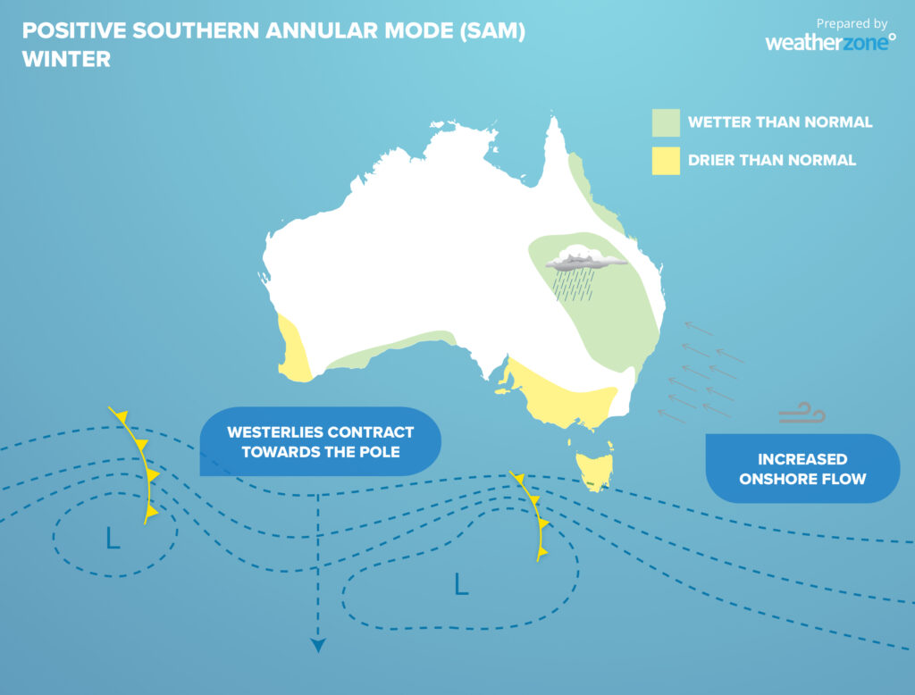
For Australia’s alpine addicts, the SAM can also influence snow. More snow expected to fall in the Australian alps when the SAM is negative and less snow occurs when it’s positive.
What’s the SAM doing now?
After being in a positive phase for much of summer, the SAM has just shifted into a negative phase.
This transition has coincided with one of the strongest cold fronts so far this year crossing southeastern Australia. This system has brought the first cool snap of the year to the region and a dusting of snow to Tas on Tuesday, along with strong and blustery southerly winds.
The image below shows the SAM forecast for the next few weeks.
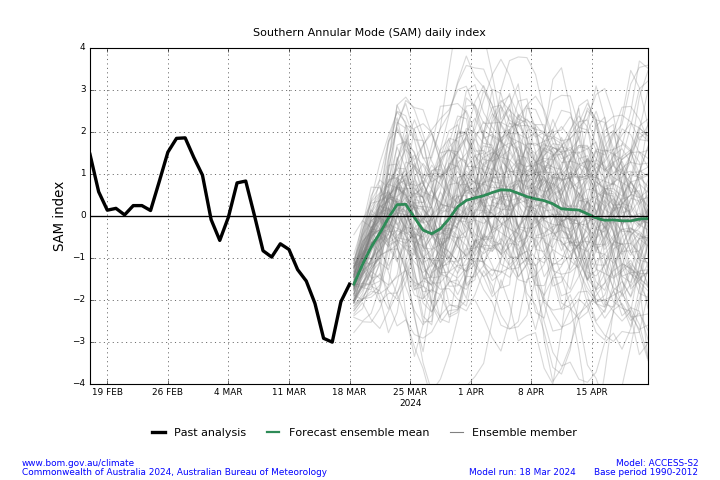
Image: Southern Annular Mode average daily index forecast (green line) and observations (black solid line).
The image above shows that the SAM will return to neutral this week, which means it will not have a major influence on Australia’s weather.
Looking further ahead, forecast models are suggesting in the coming months that the SAM should slightly favour the positive phase. This means that we could see lighter winds, increased rainfall in the east, while the south should see slightly less rainfall over the coming months. For more information on our seasonal forecasts, please contact us at apac.sales@dtn.com.


