Perth is about to obliterate its record for the longest run of days above 25°C in May as the city experiences an unusual run of late-season warmth.
A lack of strong cold fronts and frequent easterly winds have been causing an uninterrupted spell of warm days in Perth over the past week. This warm weather has been driven by the stubborn high pressure systems located south of Australia, a pattern which looks set to continue for at least the rest of this week.
As of 9am AWST on Tuesday, May 14, Perth had registered seven consecutive days above 25°C. Wednesday should reach around 28°C in the city, extending the run to eight days in a row. This will match Perth’s May record for consecutive 25°C days, which occurred in 2009 and 1985.
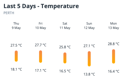
Image: Maximum and minimum temperatures in Perth over the last five days.
Based on current forecasts, the city could exceed 25°C each day for the rest of this week and possibly into early next week. This would extend the run to 13 days by Sunday, blowing the old May record out of the water.

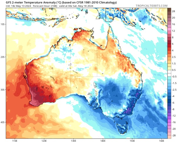
Image: Forecast 2-metre air temperature anomaly for Sunday afternoon, according to the GFS model. Source: tropicaltidbits.com
While 25°C is by no means extreme heat, the persistence of these daytime temperatures is not something Perth has seen this late in the season in 125 years of records. The average May maximum temperature in Perth over the last 30 years has been about 22°C.
There are two key factors at play with this record-breaking weather in Perth:
- A stagnant weather pattern involving abnormally high pressure to the south of Australia is preventing any significant cooling in southwestern Australia this month.
- Climate change is making warm weather records more likely. The average autumn maximum temperature at Perth Airport increased by 2.15°C between 1910 and 2022.
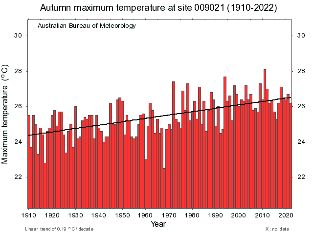
Image: Average maximum temperatures during autumn between 1910 and 2022 at Perth Airport. Source: Bureau of Meteorology
The weather pattern that is causing this record-breaking run of warmth is also starving the city of much needed rainfall.
Perth hasn’t seen any rain for the past 12 days and has only picked up 8.4 mm so far this month. This continues a prolonged run of dry months that just saw the city endure its driest October to April period on record.
Looking ahead, there are early signs that a low pressure trough could bring lower temperatures and some much-needed rain to Perth in the second half of next week. However, it’s too early to know with certainty, so be sure to check the latest forecasts next week for more accurate details.
Weatherzone Business has grown to become the outright leader within the Australian energy market, serving wind, solar, hydro, trading, utilities and network companies.
You can’t control the weather, but you can gain precision insights to optimise your response. What lights us up is providing your energy business with tailored weather information to reduce your risk and keep you moving ahead of the curve.
Our services cover all aspects – from wind and solar generation to demand forecasts, wholesale markets to retail so, no matter where your company sits, we have solutions for you. We have worked closely with market participants to create products that meet the evolving needs of the sector, aiming to increase safety and profitability for our customers.
Benefit from the timely delivery of accurate weather information, allowing informed and effective decision-making. For more information, please contact us at apac.sales@dtn.com.


