

Cool, dry air replaced uncomfortable heat and humidity on the weekend, causing parts of the NEM to see the lowest summer demand on record.
After a prolonged period of heat and humidity caused by a blocking high pressure system in the Tasman Sea, a strong cold front with a polar airmass finally swept across southeastern Australia on the weekend.
The video below show a dry airmass (oranges and reds) behind this front replacing the muggy air (blues and purples) ahead of it on the weekend.
Video: Dewpoint forecast from Thursday, February 13 to Sunday, February 16, according to ECMWF
This change also affected Sydney over the weekend, with the city’s dewpoint dropping from 22°C at 3 p.m. on Friday, February 14, to 6°C by 3pm on Sunday, February 16.
The higher the dewpoint, the greater the amount of moisture in the atmosphere, making it difficult for people to cool down through the evaporation of sweat. The dewpoint is the temperature at which air must be cooled to achieve a relative humidity of 100% or saturation of moisture in the atmosphere.
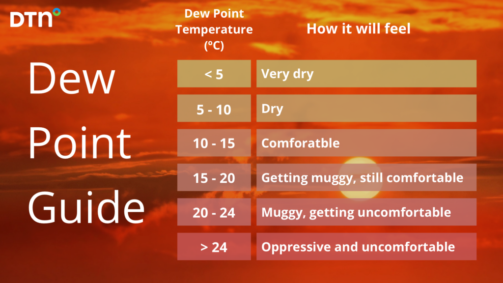
For example, this is how different dewpoint temperatures would make you feel if you were accustomed to Australia’s sub-tropical climate.
 ‘
‘
The whole of southeastern Australia also experienced a strong unseasonable chill as well as the drop in humidity which made the cool dry air feel all the brisker.
- Melbourne shivered through its coldest morning this early in the year for 37 years, when the mercury dropped to 9.9°C on Sunday morning.
- Monday morning was Sydney’s coolest February temperature in 12 years, and while the low of 14.5°C doesn’t seem particularly cold, bear in mind that the running average minimum for February 2025 to date was 20.5°C before today.
- Canberra dipped to 3.1°C on Sunday morning and 4.2°C on Monday morning – the first time the mercury had plummeted to single digits this February.
The cool and dry air caused energy demand across the NEM to drop to 547 GWh/day on Sunday, February 16, the lowest the NEM has seen since Christmas day 2024. This comes after several warm and humid spells during early and mid-February when energy demand reached around 600 to 700 GWh/day.
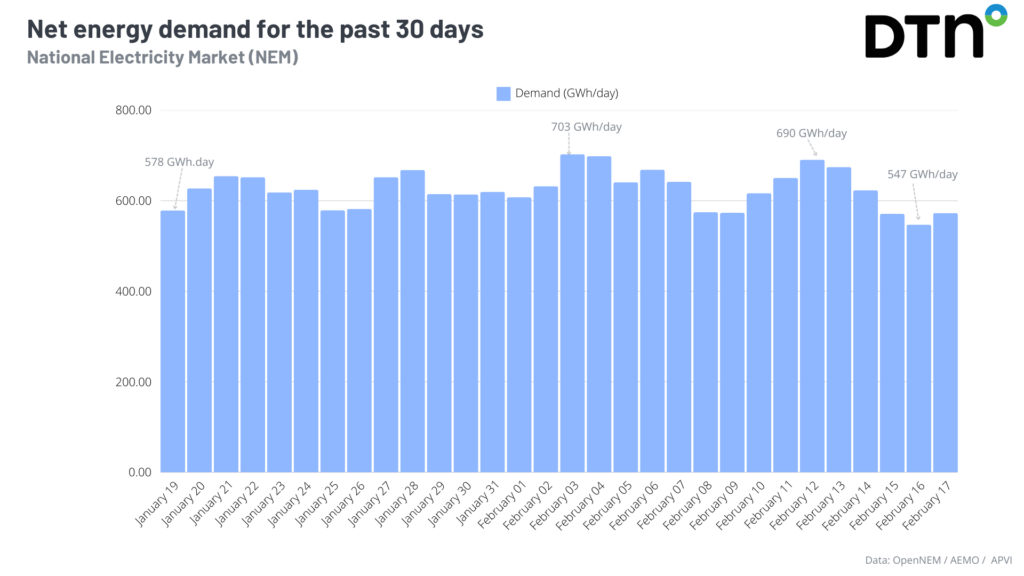
NSW and SA both saw the lowest summer energy demand on record on Sunday, with 2781 GWh/day and 35 GWh/day respectively.
The National Electricity Market has indeed been stretched by the oppressive days and nights, with humid air reaching the usually dry central and southern parts of the country.
The map below shows that January’s dewpoint was above average for eastern and western Australia, while central Australia was very dry and hot,
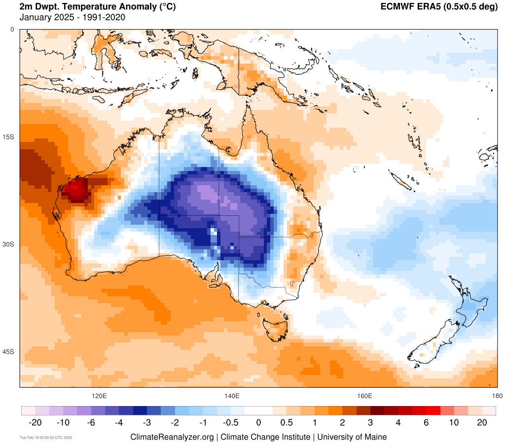
Image: Dewpoint anomaly compared to 1991 to 2020 climatology for January. Source: ClimateReanalyzer
The unusually humid conditions are being caused by very warm oceans surrounding Australia, particularly on the east and west coasts.
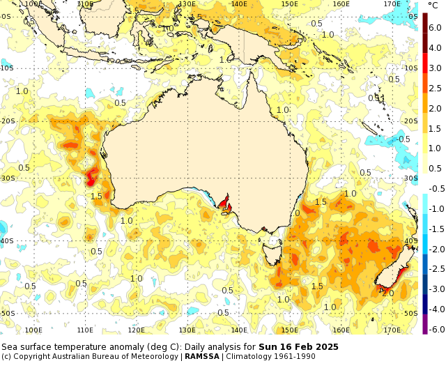
Image: Sea Surface Temperature anomalies on Sunday, February 16. Source: Bureau of Meteorology
The warm oceans are increasing moisture in the atmosphere, making it humid whilst increasing shower and storm activity across the country.
Onshore winds transporting the humid air above these warm oceans will increase humidity again across eastern Australia later this week into next. Cooler than average conditions will also continue across the NEM until later this week, when heat builds ahead of a cold front.
DTN APAC has grown to become the outright leader within the Australian energy market, serving wind, solar, hydro, trading, utilities and network companies.
You can’t control the weather, but you can gain precision insights to optimise your response. What lights us up is providing your energy business with tailored weather information to reduce your risk and keep you moving ahead of the curve.
Our services cover all aspects – from wind and solar generation to demand forecasts, wholesale markets to retail so, no matter where your company sits, we have solutions for you. We have worked closely with market participants to create products that meet the evolving needs of the sector, aiming to increase safety and profitability for our customers.
Benefit from the timely delivery of accurate weather information, allowing informed and effective decision-making. For more information, contact us at sales.apac@dtn.com




