
It has been quite an eventful week with the first tropical cyclone of the season, Paddy, developing near Christmas Island, off the northwest shelf of Australia. Paddy developed early in the cyclone season, the average date for cyclone development in Australia is around January.
La Nina also was officially declared on Tuesday, November 23, which typically brings a wet, cloudy and mild summer to Australia.
Summer is less than a week away, but southeastern Australia is experiencing unseasonably cool, cloudy and wet weather this week. So, what is happening?
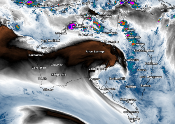
The widespread rain, cloud and severe storms on the forecast this week are a result of warm tropical moisture from both the Pacific and Indian Ocean colliding. The image below shows water vapor or moisture streaming down from the Indian Ocean towards southern and eastern Australia on Wednesday evening, November 24.

The tropical air has combined forces with an upper-level low-pressure system, generating widespread rain, low solar output, severe storms and cool temperatures across eastern Australia on Thursday and Friday.
This unsettled weather will focus on northeastern SA, QLD, NSW, the ACT and northern and eastern Victoria on Thursday and Friday, with the risk of flooding in these areas.
Widespread rainfall totals of 20-50mm are predicted in these areas over the next two days to Saturday, November 27 at 11am. Isolated pockets of 60-100mm in 48 hours are expected, particularly in thunderstorms (figure 1).

Figure 1: Accumulated rainfall over the next two days to 11am Saturday, November 27.
Thick cloud is expected to blanket eastern Australia for the next 2 to 3 days, reducing solar output in these areas. Severe thunderstorms are also likely across much of NSW and QLD on Thursday and Friday, particularly northern inland NSW and central and southern Queensland.
Heavy rainfall is the most likely hazard, although damaging winds, large hail and even tornadoes are not out of the question. In fact, 44mm was recorded in 1 hour over the southern Riverina District, NSW this morning in a severe thunderstorm.
Thunderstorms are likely to continue in NSW and QLD each day until at least Thursday, December 2, as a trough lingers in the area. The cloud, rain and cool, brisk southerly winds are causing unseasonably cool temperatures for the southern states today and for the eastern states from Friday, November 27.
Bankstown’s temperatures on both Saturday and Sunday are unlikely to exceed 19 degrees, which is nearly eight degrees below November’s average.
While temperatures in the next few days are expected to remain cool, the southern states will finally warm up from Monday until at least Thursday, December 2. Hot temperatures are expected across northern SA and northwestern NSW and VIC on Thursday, December 2 (figure 2).

Figure 2: ECMWF Maximum temperature forecast for Thursday, December 2.
For more information on Weatherzone’s solar, rain and temperature forecasting, please contact us at apac.sales@dtn.com.




