
Parched areas of southwest WA have finally seen some rain this week, with Wandering recording its highest May rainfall in more than 82 years and the most rainfall the town has seen in 13 months.
The rain event began on Wednesday, with Bunbury recording a 2-day total of 55 mm to 9am on Friday, May 3, which is the most rain the town has seen since August 2023 and a 3 year high for May. Cowaramup also saw their largest rainfall totals in two and a half years, with 60 mm recorded during the 24 hours to 9am on Thursday, May 2.
The rainfall intensified on Thursday as severe thunderstorms and a cold front swept across the region, with some towns recording more than 100 mm of rain in a day in the southwest of the state.
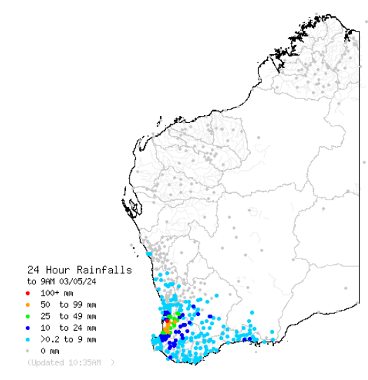
Image: 24-hour rainfall to 9am on Friday, May 3. Source: Bureau of Meteorology
The largest falls in the 24 hours leading up to 9am on Friday, May 3 were;
- Brookdale Siding, which saw 120mm
- Wandering recorded 45.6mm, its wettest May day in more than 24 years, and the most rainfall the site has seen in 13 months. This rainfall is just under a month’s worth of rain.
- Dwellingup saw 39.4mm
- Collie East recorded 38mm, a quarter of its monthly average
- Bunbury observed 35.6mm, its highest May rainfall in three years
- Karnet hasn’t seen rainfall like this since July 2022, with 35mm falling in the guage.
Much of this rain fell in a matter of hours as severe thunderstorms lashed the southwest of the state. The areas that saw the most intense rainfall on Thursday, May 2 were:
- Brookdale Siding saw 66 mm in the 3 hours to 5:45pm, which has only a 1% chance of occurring in any given year
- Bunbury recorded more rainfall in an hour than it has in the last 7 months, with 17.6mm falling in the hour leading up to 11am. During the 7 months before May 2024, the site has seen only 15.8mm.
- Mount William recorded 45.4 mm in the 1 hour to 1:05pm.
The video below shows a waterspout off the Mandurah coast in WA on Thursday, May 2
Video: Waterspout and storm clouds off Mandurah coast WA on Thursday, May 2. Credit: tomproudfoot
The rainfall that has fallen over the past two days has been very welcome for those in the southwest suffering from the driest 7-month period on record.
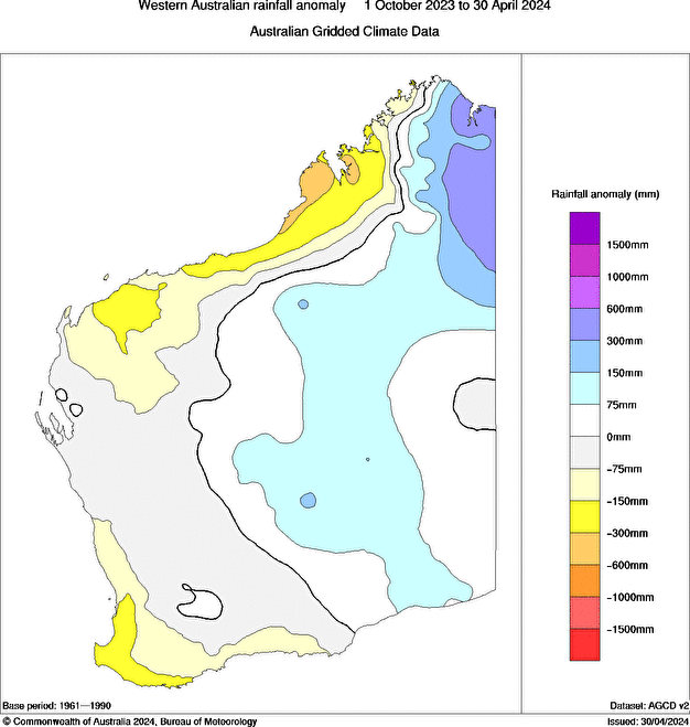
Image: Rainfall anomalies between 1 October 2023 to 30 April 2024, source Bureau of Meteorology.
While this rainfall was not drought-breaking, it has been a great start to May and will go a long way to reducing these rainfall deficiencies in some areas.
Stormtracker is a severe weather solution that can assist you in observing, in real-time, any storm or event that has the potential to impact your business. Embedded in DTN APAC’ industry interfaces, the system gives you a time advantage when monitoring conditions developing over your infrastructure and location.
Stormtracker is our Global Information System (GIS) tracking tool, providing multiple weather layers and zoom controls overlaid on a map of your location and infrastructure. You can choose a snapshot or full screen view, depending on your requirements. The maps allow you to monitor all weather, and specifically any systems likely to cause risk for your business. You also have the capacity to observe:
- real time lightning and thunderstorm alerts
- localised lightning strike frequency
- official warnings for storm, cyclone, wind, flood and fire
- sentinel hotspot fires and fire agency current incidents
Stormtracker’s radar imagery updates every 10 minutes, so you are always able to respond rapidly to changing conditions. You can customise alerting to notify you when your staff or infrastructure are under threat. With increased situational awareness, your ability to make informed decisions quickly is optimised.
DTN APAC’ experience and intelligence gives you a clear path through complex situations. Let us assist you, offering actionable insight when extreme weather poses risk to your business. For more information, please contact us at apac.sales@dtn.com.


