
Large areas of Australia are enduring cold and frosty mornings this week as high pressure systems keep skies clear across much of the country.
While June featured several northwest cloud bands and widespread rain across Australia, clearer skies have returned to much of the country this week, which has been good news for solar output.
However, the abundance of clear and dry air is allowing overnight temperatures to plummet, increasing the load on the National Electricity Market (NEM).
How cold is it?
Minimum temperature records aren’t likely to be broken this week. However, some areas will see multiple mornings of frost and the chill will be felt in parts of the NEM (figure 1).
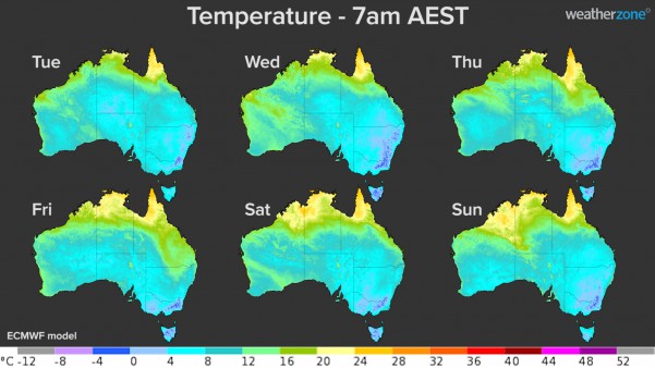 Figure 1: Modelled surface air temperature at 7am AEST each morning between Tuesday and Sunday.
Monday and Tuesday mornings for Brisbane, dropped to around 10ºC, 3ºC below the July average minimum temperature.
Parts of central and southeastern Australia will see temperatures low enough for frost on several mornings. This includes Roma in Queensland, which should reach about 1ºC on Wednesday morning.
After reaching –3.1ºC on Tuesday morning, Canberra is forecast to reach -2ºC on Wednesday and Thursday and 1ºC each morning for the rest of the week. The city’s average minimum temperature in July usually sits around 0ºC.
Hobart should drop to 2-4ºC each morning for the rest of this week, which is a few degrees below its July average low of around 5ºC. Anything lower than 2.3ºC will be the city’s coldest morning so far this year.
Melbourne is forecast to reach 3-4ºC in the morning from Wednesday to Saturday, which is about 3-4ºC below average for this time of year.
Bankstown has shivered through cold mornings since Sunday, which dropped to near 3ºC, 3 degrees below normal for the his time of year. At Sydney Observatory Hill, Monday and Tuesday morning temperatures dropped to 6-7ºC, around 2ºC below the average.
Adelaide, Sydney and Brisbane will be spared from anything too cold for the rest of the week, with overnight lows predicted to be near or above average for this time of year between now and Sunday. While Bankstown’s minimum temperature is set to remain below average for another two mornings, before trending to above average Friday morning.
Why are nights so cold?
Clear skies, light winds, and dry air beneath large high pressure systems are providing ideal conditions for cold overnight temperatures in Australia this week.
Cloud acts like a blanket at night by trapping some of the previous day’s warmth close to the ground. But on clear and calm nights, heat can radiate away from the ground freely, which causes air near the ground to become progressively colder throughout the night.
Our coldest mornings of the year usually occur when overnight cooling is allowed to continue unabated by clouds, wind, or the formation of fog.
Under these conditions, the minimum temperatures will typically occur near or just after sunrise, before the rising sun starts to warm up the ground once again.
For more information on Weatherzone’s 14-day temperature forecasts and risks of extreme temperatures, please contact us at apac.sales@dtn.com.




