
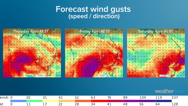
A surge of powerful winds will hit the NEM during the next three days as a deep low pressure system and a series of cold fronts passes southeastern Australia.
Vigorous northwesterly winds will strengthen over South Australia on Thursday as the low passes to the south of SA and gradually moves east.
These winds are expected to average around 50-70km/h in the state’s south, with gusts possibly exceeding 90km/h in some areas from the afternoon into Thursday night.
The cold, wet and windy weather will continue into Friday as another vigorous cold front barrels over the state (figure 1). Once again, damaging winds, locally heavy rain and thunderstorms are all on the cards for Friday.
Are all wind speeds good for wind farms?
Strong winds are usually great news for wind farms. However, sometimes the winds are too strong. There is a sweet spot when it comes to wind power.
Wind gusts above 90km/h (25m/s) can damage the wind turbines and the propellers if they are spinning.
Wind farms may have to turn the turbines off if the winds reach the ‘cut off’ wind speeds (25m/s) to ensure the strong winds do not damage the turbine.
If the winds are too strong, wind power capacities may be reduced for periods of time when the turbines are turned off.
Unfortunately for SA wind farms, the wind gusts during the next few days may exceed the cut out criteria, potentially forcing the wind farms to turn the propellers off.
Will the strong winds spread across the NEM?
On Friday and Saturday, a significant cold front will move through the NEM, with the strong wind power spreading across the remainder southeastern Australia (figure 1).
Wind farms in VIC and NSW are likely to hit the wind power sweet spot, with SA coping the most damaging of winds.
Wind power is likely to ease from Sunday, as a high pressure system finally moves into the low pressure systems wake.
Is there another reason for this particularly windy period?
Yes, the Southern Annular Mode (SAM) is currently negative, promoting windy, wet and cool weather across southern Australia.
To recap what the SAM is, it is an index that measures the north-south displacement of the westerly winds that flow between Australia and Antarctica.
When the SAM is in a negative phase, westerly winds and cold fronts are located further north than usual, which typically causes more cold outbreaks and increased wind power and rainfall for southern Australia.
On the other hand, positive SAM phases can generate heatwaves and reduce wind power and rainfall for southern Australia, during spring and summer.
While the SAM is negative now, models suggest that it will move into neutral territory (cold fronts at normal position) from late July right through until early August.
Weatherzone forecasts wind power out to 14 days, as well as providing seasonal forecasts to our energy clients. For more information, please contact us at apac.sales@dtn.com.




