Australia has shivered through its coldest night of 2024 to date, with freezing temperatures recorded in New South Wales, Victoria, and Tasmania.
- A year-to-date low for Australia of –5.7°C was recorded at Perisher Valley in NSW
- The coldest overnight temp in Victoria was –3.1°C at Mt Hotham, the state’s coldest for 2024 to date.
- Tasmania only fell to zero at one location (Fingal) due to consistent overnight westerly winds, falling well short of its YTD 2024 low of –2.8°C on Jan 30 at Liawenee on the Central Plateau
- Towns situated on the plains to the east of the mainland high country also had very cold nights for March, including –0.7°C at Omeo (Vic) and –1.9°C at Cooma Airport (NSW).
- South Australia came close to zero at a few spots, with a low reading of 1.5°C at Coonawarra
- Canberra also had its coldest night of the year thus far with a low of 2.3°C and it was quite the change after a minimum of 18.7°C the night before. That’s a drop of 16.4°C!
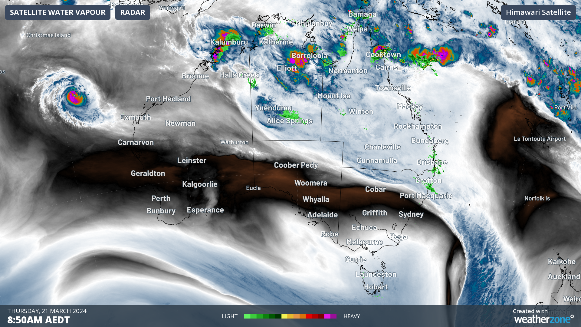
The Thursday morning satellite image shows how the midweek cold front that whipped through southeastern Australia has now moved well out over the Tasman Sea. In its wake, cool, dry air lingers across the southeast, especially on the mainland.
A mild and mostly dry spell of weather with cool nights is now on the cards for the next few days across most of Tas, Vic, SA, NSW, and the ACT.
Further north, there’s rain in store for large parts of Queensland, the NT, and northern WA. The satellite image also shows Tropical Cyclone Neville which was declared overnight in waters off northwestern WA.
Neville is likely to become quite a strong cyclone, potentially reaching Category Four, but it is expected to track away from the coastline and not directly impact Australia.
Independently verified to significantly outperform other industry models, Opticast gives you a strategic advantage if weather impacts your enterprise. Armed with the most accurate nowcasting and forecasting data, you can mitigate operational and safety risks, and plan to make the most of severe weather windows.
Opticast is powered by machine learning, intelligently adapting to the local conditions of your site area. Gain a world-leading forecasting system that rapidly responds to changing conditions.
We give you the foresight to make quick and powerful decisions when you need to protect your valuable team and assets, and ensure maximum productivity. For more information, please contact us at apac.sales@dtn.com.


