
A northwest cloud band will deliver widespread rain and thunderstorms over central and southeastern Australia during the next four days.
The cloud band is developing as moisture-laden air from the tropics moves south and interacts with a cold front passing over southern Australia. The satellite image below shows the cloud band developing over WA and SA on Thursday morning.
Over the next four days, the cloud band will progress further east, causing widespread rain and thunderstorms in parts of SA, VIC, QLD, NT, ACT and NSW.
The passage of the cold front will also cause damaging winds and a big drop in temperature across the nation’s southern states.
Wind, rain and thunderstorms
The injection of tropical moisture will produce rain in parts of every state and territory during the second half of this week.
THURSDAY
On Thursday the rain will begin in southern WA before moving into SA later in the evening. Falls will be mostly light as the cloud band is just taking shape.
In addition to the rain, damaging north to northwesterly winds averaging 50-65 km/h with peak gusts up to 90-100 km/h are forecast to develop ahead of the approaching front in parts of South Australia and Victoria.
Damaging wind gusts had already reached 80 km/h at Cape Willoughby in SA and 104 km/h at Mount William in VIC on Thursday morning.
FRIDAY
Rain and storms will become more intense and widespread on Friday as the cloud band thickens and moves further east.
The rain will begin in SA before spreading into western NSW, VIC, TAS and the Red Centre. The heaviest rain will develop over TAS from the morning and VIC from the afternoon.
There will also be a line of thunderstorms developing Thursday evening in SA progressing east into VIC and NSW overnight into Friday. Some of these storms could be severe, most likely due to damaging wind.
Strong and potentially damaging winds, independent of thunderstorms, will also spread further east across parts of Victoria, Tasmania, and southern NSW on Friday.
SATURDAY
During Saturday, rain will continue to spread over central and eastern Australia, affecting areas from eastern VIC right up to the NT.
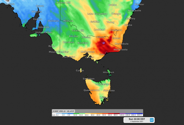
Eastern VIC and southeastern NSW will see the heaviest rain, possibly enough to cause flooding given catchments are already saturated in some areas following a wet winter.
SUNDAY
On Sunday the rain band will stretch from the NT through southern QLD into northern NSW, while showers will continue in eastern VIC and southeastern NSW near a developing low-pressure system.
Accumulated rainfall totals between Thursday and Sunday are likely to reach 5-20mm over a widespread area from the NT down to TAS.
Eastern VIC and southeastern NSW could see falls of 50-100mm over this four-day period, with pockets of 100-150mm possible on the ranges.
Dramatic temperature drop
Another significant feature of this cold9 front will be a large drop in temperature as it passes over southern Australia.
Warm northerly winds ahead of the front will be replaced by much colder southwesterlies in the wake of the front.
Temperatures could drop by 17ºC in Adelaide and 12ºC in Melbourne in the space of one or two days. This cold weather is likely to continue well into next week as southerly winds persist over southern Australia.
Weatherzone provides accurate wind, temperature, cloud and rain forecasting to our clients, for more information, contact us at apac.sales@dtn.com.




