Australia just shivered through its coldest night of the year to date with a low of –9.6°C at Thredbo Top Station, but it wasn’t just the mountains feeling the chill.
Right across southeastern Australia, temperatures were frigid in the wake of the cold front that passed through on Saturday night, and the wind chill added to the equation.
- Sydney dipped to 6.4°C early on Monday morning, which was its second-coldest night of the year to date, but the remarkable figure was the apparent or “feels like” temp which fell to –0.1°C at 6 am due to the wind chill. Yes, it officially felt “freezing” in Sydney this Monday morning, which anyone standing at a bus stop could have told you.
- Canberra had a low of –5.4°C, its third-coldest night of the year to date.
- Melbourne didn’t have a particularly cold night with a low of 6.8°C but we mention Melbourne here because it is set for a string of extremely chilly nights, with a low of just 1°C expected on Wednesday morning for the city, with subzero temps in some outer suburbs.
- Cold days also lie ahead for Melbourne, with tops of just 12 or 13 degrees on the cards all the way through till Saturday.
- Indeed the whole of southeastern Australia will stay cold in the days ahead, with even Byron Bay in the northeastern tip of NSW staying under 20°C all week.
One spot that missed the chill on Sunday night into Monday morning was Brisbane, which had a very balmy minimum of 18°C, its warmest July night in six years. Why?

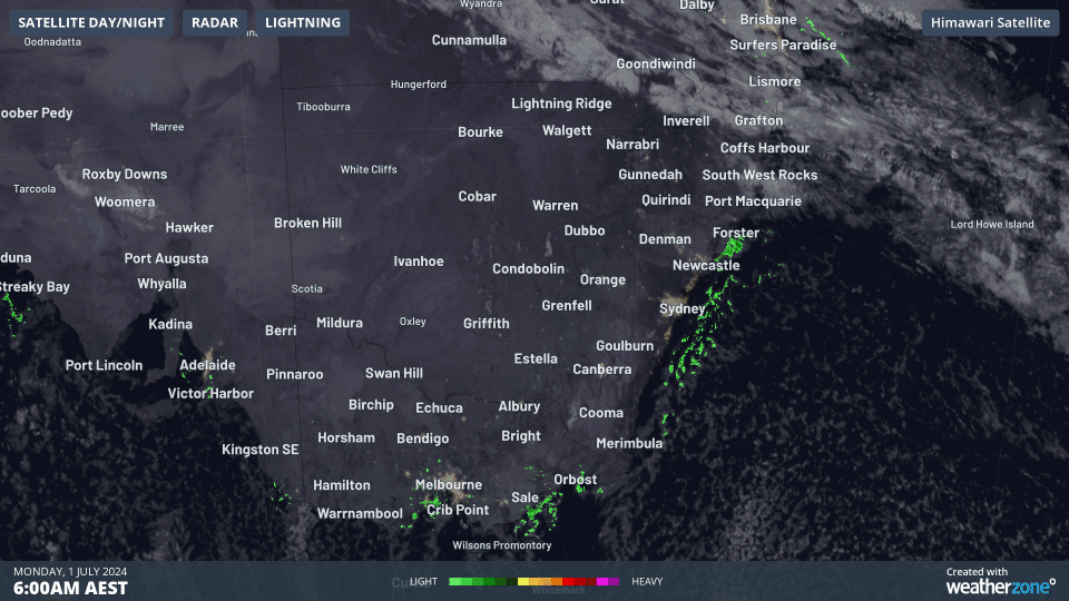
Check out the satellite and radar loop above showing the three-hour period up till 9 am Monday.
See how the cold air associated with the speckled cloud field off the NSW south coast hasn’t quite made its way as far north as the Queensland border yet?
Notice how cloud associated with a warmer airmass is still streaming across southeast Queensland from the northwest?
That cold air will eventually reach Brisbane, along with some rain driven onshore. Brisbane has already topped 20°C before lunchtime this Monday, but by Tuesday, Brisbane should reach a maximum of just 17°C with persistent showers. That will be by far its coldest day of 2024 to date.
A chilly week is in store for the most populated corner of the country, which is pretty much what you’d expect for the first week of July, but some of the temps will still be well below average, even by midwinter standards.
Weatherzone Business has grown to become the outright leader within the Australian energy market, serving wind, solar, hydro, trading, utilities and network companies.
You can’t control the weather, but you can gain precision insights to optimise your response. What lights us up is providing your energy business with tailored weather information to reduce your risk and keep you moving ahead of the curve.
Our services cover all aspects – from wind and solar generation to demand forecasts, wholesale markets to retail so, no matter where your company sits, we have solutions for you. We have worked closely with market participants to create products that meet the evolving needs of the sector, aiming to increase safety and profitability for our customers.
Benefit from the timely delivery of accurate weather information, allowing informed and effective decision-making. To find out more, please contact us at apac.sales@dtn.com.


