Huge 24-hour rainfall totals have again been recorded in and around Sydney region, with over 200 mm of rain recorded at some spots to 9 am Friday.
The rain was heaviest in the Illawarra region just south of Sydney, with extremely heavy falls also recorded in the Southern Highlands, most of which lies in the catchment of Sydney’s largest water storage reservoir, Lake Burragorang, which is dammed by Warragamba Dam.
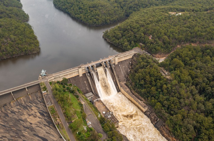
Warragamba Dam began spilling water at 4:20 am, its third spill for 2024.
NSW rain showing no signs of moving on from the Illawarra. Falls on the Highlands are causing the Nepean, Nattai and Wollondilly rivers to rise, the latter two draining into a nearly full Lake Burragorang (behind Warragamba Dam). https://t.co/VNwIu84TVV pic.twitter.com/MenjjzeI6H
— Andrew Miskelly (@andrewmiskelly) June 6, 2024
Anytime that happens, there are always flooding fears for residents living in low-lying areas downstream, and a minor to moderate flood warning is in place for the Hawkesbury-Nepean River.
Moderate flooding is also occurring upstream of Warragamba Dam along the Upper Nepean River.
The Nepean River at Menangle Bridge is well over the moderate flood level of 9.20m and expected to peak near 11.00 metres at Menangle Bridge early on Friday afternoon.
This is the latest recent heavy rainfall event that has targeted parts of the NSW coast and ranges within close proximity to Sydney. Red dots on the map below show locations that received over 100 mm of rainfall to 9 am Friday.
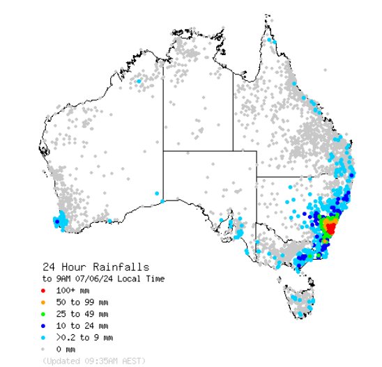
Source: BoM.
If you zoom in on the Greater Sydney region, you can see where the heaviest rain fell. You can also see Lake Burragorang near the blue word “Warragamba” around the centre of the image.
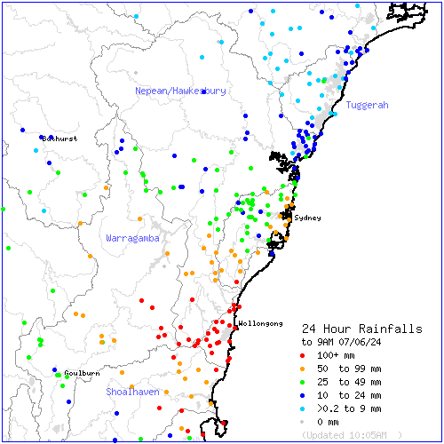
Source: BoM.
The heaviest falls included:
- 214 mm at Scarborough, a northern seaside suburb of Wollongong.
- 204 mm at Port Kembla, in the south of Wollongong.
- 151 mm at High Range (in the catchment area for Lake Burragorang/Warragamba Dam).
- 131.2 mm at Kiama just south of Wollongong (its heaviest daily fall in two years and heaviest daily June total in eight years).
- 126.8 mm at Moss Vale in the Southern Highlands (heaviest daily June total in eight years).
A severe weather warning for parts of the Illawarra and south Coast regions is in force, so please be careful out there and remember to keep checking the latest warnings on our warnings page.
Are you protecting your enterprise from increasingly volatile weather risk?
You can’t control the shifting climate, but you can gain precision insights to optimise your response.
DTN APAC, a DTN company, has been providing weather intelligence and innovative forecasting systems to Australian businesses since 1998.
We have intuitive solutions that serve industries from aviation, mining and energy right through to marine, and everything in between. Rest assured, if we don’t already have a product to address your business’ weather needs, we will work tirelessly to create one.
With our network of global partners, we provide trusted, industry-leading services that can mitigate weather risk, keep your valuable staff and assets safe, and ensure you are operating at peak efficiency. For more information please contact us at apac.sales@dtn.com.


