

Prosper in a dynamic world
Search

Another hot week in Perth


Perth could get close to 40ºC on each of the next five days as a Severe Heatwave grips Australia’s west coast.

A near-stationary high pressure ridge over WA and a persistent West Coast Trough will direct a stream of hot easterly winds over Australia’s west coast during the remainder of this week.

This synoptic setup is common in summer, and it’s known to produce lengthy heatwaves in Perth as hot offshore winds delay the Fremantle Doctor.

Maximum temperatures are likely to reach 38 to 40ºC in Perth every day between Tuesday and Saturday, and could hit around 34 to 37ºC each day from this Sunday until Wednesday next week.
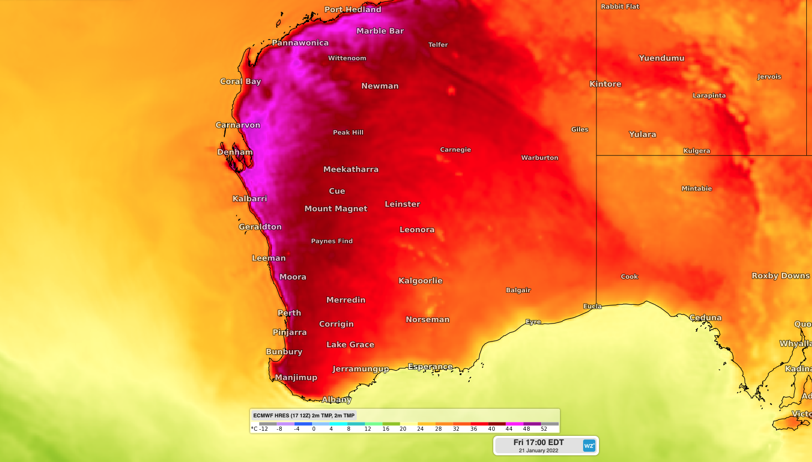
Image: Forecast surface air temperature along the west coast on Friday afternoon, according to the ECMWF model.

This week-long run of hot days continues a sweaty start to summer in the WA capital city.

Perth registered five days at or above 40ºC in December, which hasn’t happened since 1997. Four of these 40ºC days were consecutive, which is a feat that’s only happened on two other occasions in the records dating back to 1897.

This week’s heat will cause a Severe to locally Extreme Heatwave in western coastal districts of WA, from the Southwest Capes up to Exmouth.

This persistent heat will contribute to Very High to Extreme fire danger ratings over the coming week. For more information on Weatherzone’s temperature, extreme temperature and fire forecasting, please contact us at apac.sales@dtn.com.


Latest news

Satisfy your weather obsession with these news headlines from around the nation, and the world.

Signs of a positive Indian Ocean Dipole, but it may not follow the textbook

Waters off Indonesia have cooled in recent weeks, an indication that a positive Indian Ocean Dipole (IOD) event could be developing. It’s an important climate driver for Australia, and it could shape rainfall and temperatures heading into summer, with flow-on effects for farmers, energy and other industries.  What is the Indian Ocean Dipole?  The IOD […]

1.3 million lightning strikes and a record September downpour: the storms testing WA’s Goldfields

Leonora, WA, had its wettest September day on record earlier this month. Three weeks later, more than 1.3 million lightning pulses were detected within 800 km of the town in 48 hours. Why is a stalled trough delivering storms to mining country, and what it could mean for operations?  The DTN Total Lightning Network detected […]

A very low wind power week, likely to continue

A stubborn blocking high over southern Australia will make for a very quiet week for wind generation and the pattern behind it isn’t a one-off.   It’s the seasonal signature of a super (very strong) El Niño combined with a positive Southern Annular Mode (SAM), and both the historical record and the current seasonal forecast suggest it’s likely to keep recurring through spring before a potential switch from November.  The setup right […]

Fastest strengthening El Niño on record: Impacts on Australian monsoon timing and wet season planning

Australia’s Mining and Resources sectors are bracing for a wet season shaped by one of the most rapidly developing El Niño events on record.    Looking back at how the strongest El Niño events in Australian history have played out, it becomes apparent that mining operations in Australia should be planning for a later monsoon […]

