Prosper in a dynamic world
Search

A wet week for Tassie hydro


Parts of Tasmania have seen a months worth of rainfall in the last week, providing a decent injection of water into the Tassie hydro lakes.

August is Tasmania’s second wettest month with a state-wide monthly average of 148.2 mm. This sits just behind July (154.4 mm) and a smidgen ahead of May (135.7 mm) and September (134.9 mm).

So, it wasn’t surprising to see a processions of low pressure systems and cold fronts delivering frequent and heavy rain across the state during the past week. However, it was unusual for so much rain to fall in the state’s east, courtesy of a deep low pressure system in the western Tasman Sea.

The map below shows that most of Tasmania received around 50 to 100 mm of rain in the last seven days, with a few places exceeding 150 mm. This included 177.2 mm in one week at kunanyi / Mount Wellington, which is more rain than the mountain received during all of June and July combined.

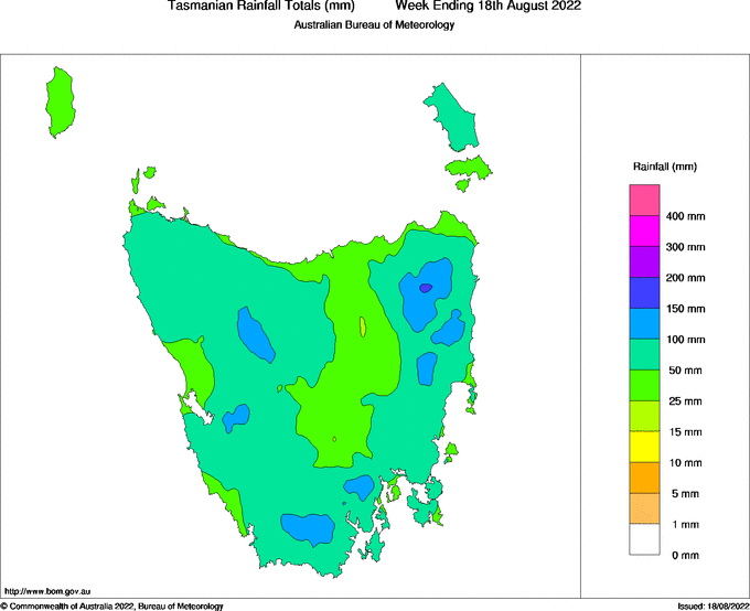
Image: Observed rainfall during the week ending on August 18, 2022. Source: Bureau of Meteorology

Hydro operators can more accurately predict hydro plant output and manage water flows through accurate long-term catchment rainfall and snowfall forecasts. Rainfall forecasts from one hour to one year ahead are crucial for effective management of hydro assets. For more information on these services, please contact us at apac.sales@dtn.com.

Latest news

Satisfy your weather obsession with these news headlines from around the nation, and the world.

El Niño Is Here: What a Potential Record Event Means for Southeast Asia and Australia

  El Niño was officially declared in June 2026, raising the prospect of widespread impacts across Southeast Asia, from extreme heat and water shortages to higher energy demand and agricultural stress.   The World Meteorological Organization has warned countries to “prepare for it to be severe”, while several global forecast models suggest the event could rank among […]

How El Niño will shape Australian port operations in winter-spring 2026

Australian ports and marine pilots can expect a season of shifting wind and swell patterns through winter and spring 2026, as a developing El Niño brings the likelihood of drier conditions and more variable operating windows across the country’s coastline.  Will El Niño develop in 2026?  There are clear signs that an El Niño pattern is becoming […]

From Kimberley to northern NSW: Bushfire outlook flags risk for resources sector this winter

Bushfire risk doesn’t usually make headlines in June, but AFAC’s winter seasonal outlook is putting mining and resources operators on alert from the Kimberley to the NSW.  Australia’s official seasonal bushfire outlook for winter 2026 was released by AFAC on Thursday, May 28. The outlook predicts increased fire risk across the northern parts of the Great Sandy Desert and surrounds […]

The signal was there weeks earlier: forecasting one of the year’s biggest wind events

In mid-May 2026, DTN APAC meteorologists flagged a strengthening Southern Ocean pattern in model guidance, signalling an extended run of record-challenging wind conditions across the NEM.  Nearly three weeks later, NEM wind generation climbed from around 1.5GW to more than 9GW, supplying roughly one-third of the grid and coming within 1GW of the all-time generation record.  The event highlighted […]