Abnormally high fire risk is anticipated across parts of South Australia and Victoria this winter as the ongoing drought causes a seemingly endless 2025 fire season in southern Australia, with reduced risk across northern Australia with recent wet months.
Increased Risk of Fire for southern Australia
Australia’s official seasonal bushfire outlook for winter 2025 was released by AFAC last week. The outlook predicts that a broad area of South Australia and Victoria will have an increased risk of fires this season, despite winter usually being a quiet time for fires in southern Australia.
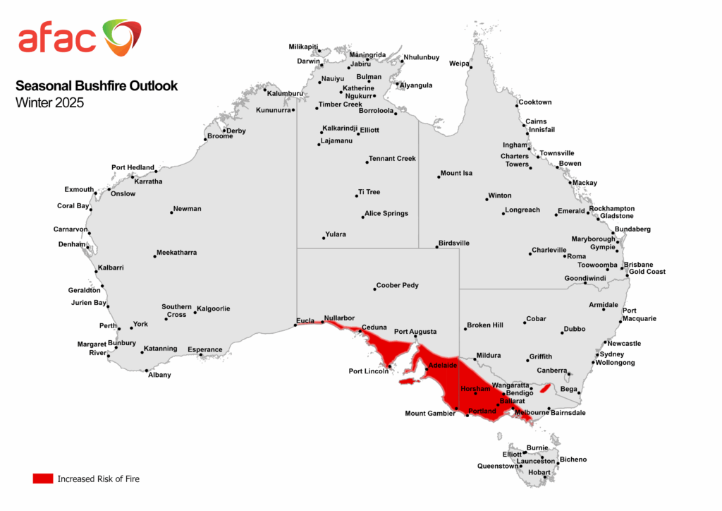
Image: Winter 2025 seasonal bushfire outlook. Source: AFAC
Winter is typically a time of year when the focus of bush and grass fires shifts northwards as increased cold front activity keeps southern Australia cold and wet. However, this winter is expected to remain an increased risk of an active fire season for the south of the country.
Ongoing rainfall deficiencies in southern Australia over the past couple of years have left an abundance of dry vegetation to burn. This increased fire fuel will combine with above average temperatures to elevate the risk of fires in parts of South Australia and Victoria this winter.
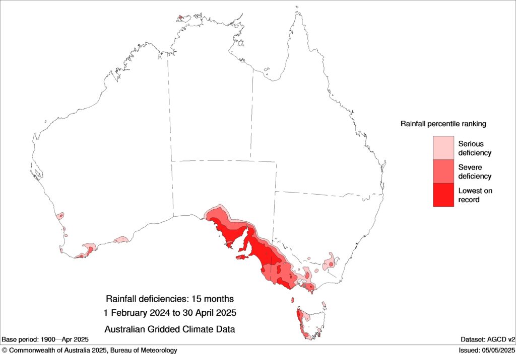
Image: Rainfall deficiencies between February 2024 and April 2025. Source: BoM
According to the AFAC outlook, cropping and grassland areas of South Australia and Victoria are grazed out or mostly bare, which will help suppress fires in these areas. However, forested areas that have underlying moisture deficits and an abundance of dry material to burn will be at an elevated risk of winter fires.
“The Seasonal Bushfire Outlook for winter 2025 identifies a heightened risk of fire for southern coastal areas of SA and significant portions of western, southwestern and southeastern Victoria,” AFAC stated in its report.
While fire behaviour will be near-normal for most other areas of Australia this winter, there are a few other areas that have been flagged as potential areas to watch this season.
Dry areas in central, western and southern NSW may be able to support winter fires this season, particularly if winter rainfall is below average.
Tasmania is also likely to see organic soils smouldering throughout winter due to the state’s ongoing deep soil dryness. These burning organic soils, which are a hangover from summer fires, are difficult to extinguish. They may persist long enough to start new fires when warmer and drier weather starts to occur later in the year.
Decreased risk of fire for northern Australia
June to August typically sees an increasing focus of bush and grass fires over northern Australia as warm, dry and windy develop with the return of the dry season. However, tropical rainfall activity persisted into May and the typical start of the dry season for tropical northern Australia. Lingering moisture from above average rainfall across parts of northern and eastern Australia will maintain a decreased risk of fire activity in the coming months.
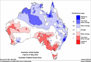
Image: Rainfall deciles across Australia during April and May 2025. Source: BoM
Boosted vegetation growth from this recent rainfall could however boost fire fuel loads later this winter and early in spring, especially across parts of the NT and central Australia.
How DTN APAC services the Forestry and Emergency sectors
Working in often severe conditions in the high-risk fields of forestry and emergency, our consolidated weather services can ensure full situational awareness for you and your team.
DTN APAC serves the forestry and emergency sectors, delivering trusted weather data and severe weather alerting to maintain safety, protect your assets and underpin your planning.
DTN APAC’s trusted nowcasting and forecasting system, OpticastTM, is independently proven to outperform other industry models, allowing you to respond rapidly to changing conditions. Opticast can ingest data from your on-site weather observation equipment, ensuring your forecast is customised to your local microclimate. From nowcasting and 14 day forecasting to seasonal outlooks, you have powerful, hyper-local weather alerting and intelligence, giving you decisive confidence when it’s most needed.
With lightning a prominent cause of forest fires throughout Australia, DTN APAC’s Total Lightning Network offers real-time detection and unsurpassed accuracy of lightning strikes to <200m. Based on a vast sensor network, both intra-cloud and cloud-to-ground strikes are located, ensuring you are alerted when severe weather is building and threatening your teams, assets and infrastructure. When volatile conditions increase the ferocity of fire it’s imperative you have lead-time to enact safety plans, keeping your people out of harm’s way.
Your weather intelligence is accessible across all devices in your network via our Weatherguard App, and your customisable interface.
We are there for you when you need us the most – 24/7, 365 days a year. Learn more about our large range of industry leading products and services or email us at sales.apac@dtn.com
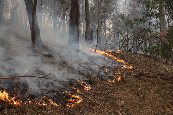
Thumbnail image source: Thomas Hogg / iStock


