
The US Climate Prediction Center (CPC) has just declared that La Niña is underway in the tropical Pacific Ocean, meaning the ocean and atmosphere are now synchronised in a pattern that is likely to influence Australia’s weather and climate in the coming months.
The CPC issued a La Niña Advisory on January 9 in response to ocean and atmospheric conditions exceeding their thresholds for a La Niña declaration. You can read more about these thresholds here, although the key aspects that led the La Niña declaration were:
- Abnormally cool sea surface temperatures in the tropical Pacific Ocean
- An atmospheric response to these cooler waters
- Forecast models suggesting that the La Niña pattern would continue for at least a few months
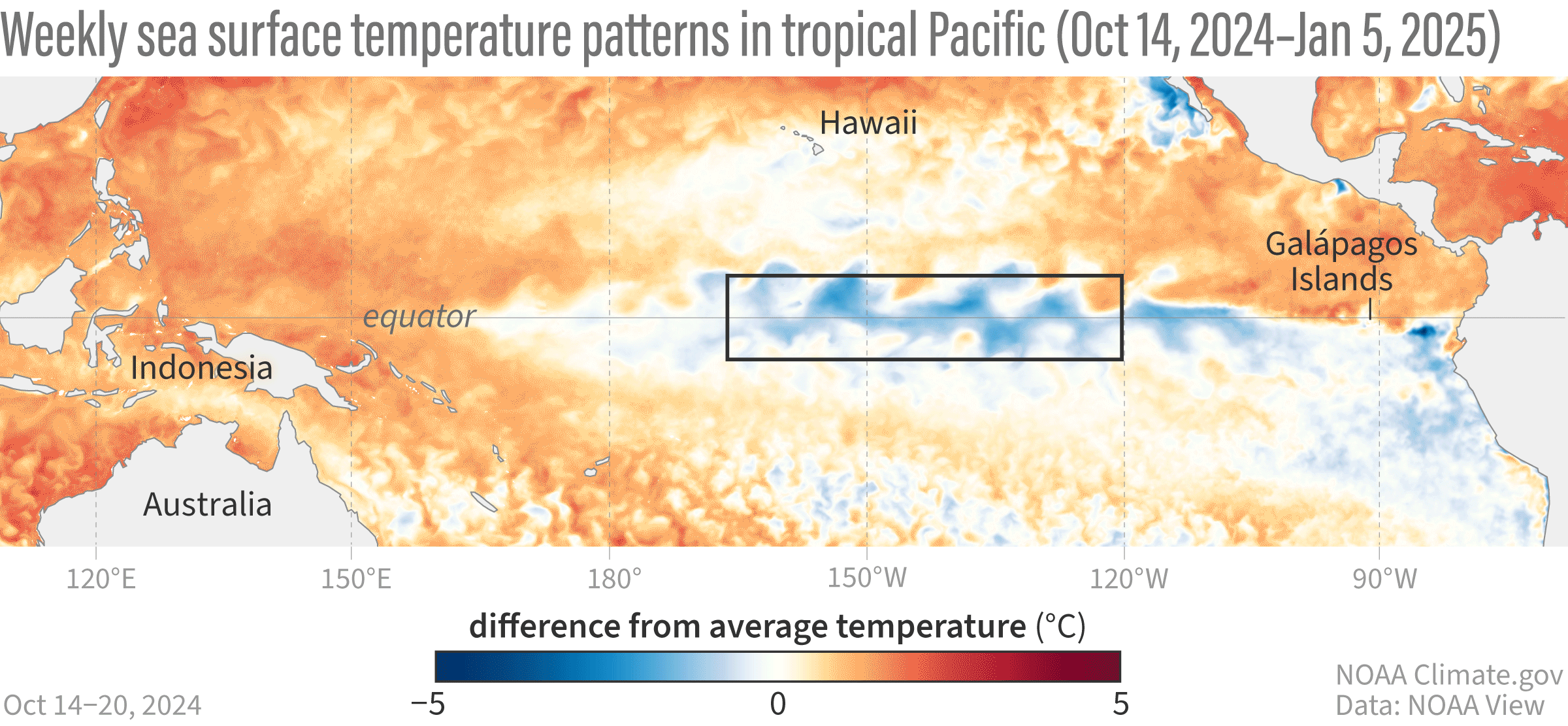
Image: Weekly sea surface temperature anomalies in the tropical Pacific Ocean in the last three months. Source: NOAA Climate.gov
Australia’s Bureau of Meteorology (BoM) has slightly different requirements for a La Niña declaration. As a result, the BoM are yet to join the CPC in officially declaring La Niña, although this may still happen in a few months’ time.
What does this mean for Australian businesses?
Despite the apparent disagreement between the US and Australian climate monitoring agencies, a La Niña pattern has become established in the Pacific Ocean, and it is expected to last for a few months.
One important thing to point out is that this is an odd time of year for La Niña to become established. La Niña events usually begin in autumn and decay in early summer, having their greatest influence on Australia’s weather during winter, spring and early summer. However, there are still known impacts of La Niña events that occur at this time of year.
The map below shows the January to March rainfall footprint from past La Niña events, with above average rain over large areas of northern and eastern Australia.

Image: Typical January to March rainfall over Australia during La Niña. Source: Bureau of Meteorology
The increased cloud cover and rainfall associated with La Niña can also help suppress daytime temperatures over large areas of Australia during summer and early autumn.
Tropical cyclone activity is more likely to the north of Australia when La Niña is in place, and bushfire weather can also be suppressed by the reduction in temperatures and rainfall in some parts of the country.
The shifting climate is bringing increased complexity and greater risks to businesses worldwide. We are here for you, delivering trusted weather solutions to optimize your operations and profitability.
DTN APAC is a diverse team, with global forecasting, product development and analytics expertise. Couple this with extensive industry experience spanning Aviation to Energy, and we are primed to assist you in strengthening your response to weather
impact.
We work hard to identify your operational pressures and tailor our services and products to meet your needs. Concise communication, giving you full situational awareness exactly when you need it, is our focus. We want to reduce weather risk in your operations, every day.
We deliver clear and comprehensive weather data, personalised risk assessments and briefings to you and your team, so that your critical decisions can be made with confidence.
We are available 365 days a year, so you always have the timely guidance you require, especially when severe conditions hit.
You have our insights to rely on to see you through complex situations, minimising potential loss of profit and maximising the safety of your staff and assets. For more information contact us at sales.apac@dtn.com
Thumbnail image:iStock / guvendemir


